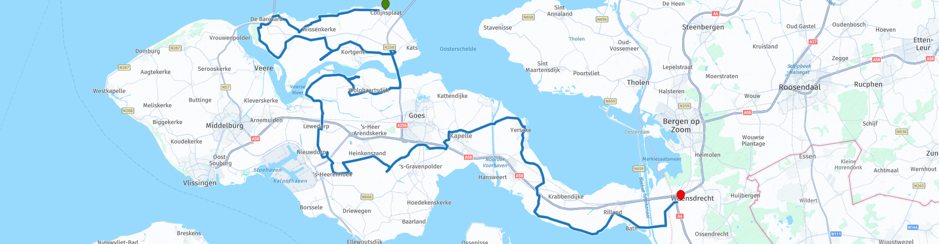
TTT 2005 03 Zeeland Colijnsplaat Woensdrecht

This route was brought to you by:
RouteXpert Hans van de Ven (Mr.MRA)
Last edit: 03-03-2019
 Route Summary
 The 173 ANWB Promoter TankTasTochten (TTT) were scanned by Henry ten Dam and signed by Leon Stolk in Mapsource and later placed as a Track in a .gpx file. These have been made available with the approval of ANWB Promotor via the website of MrGPS so that everyone can enjoy it. The 1st TTT is from 1992, so the route may be slightly different from the original.
I checked all route points and placed them neatly on the road. Also, if necessary, I have put the start point and end point of the route a bit further apart to avoid navigating directly to the end point and I have added the POI files from the start and end point just like a possible stopping point.
Finally, I created the route for TomTom, Garmin and MyRoute-app Navigation users.
With thanks to Henry, Leon, MrGPS and Promoter.
 Share this route


Animation

Verdict


Duration
3h 34m

Mode of travel
Car or motorcycle

Distance
124.36 km

Countries

 RouteXpert Review
 * The Zandkreek dam is a dam in the Zandkreek between Kats on Noord-Beveland and Wilhelminadorp on Zuid-Beveland on the Oosterscheldekant of the Veerse Meer. The Zandkreek dam is 830 meters long, and is the second building of the Delta Works. The construction of the Zandkreek dam was part of the Three Islands Plan that was developed from the 1930s to connect Walcheren and Noord- and Zuid-Beveland. After the Flood of 1953, that plan was included in the Delta Works. The Three Islands Plan was executed as the first part. In the original Delta Plan, the Zandkreek Dam was not necessary in the final situation (besides a closed Veerse Gat also a closed Oosterschelde). The dam would have a water basin closed off from the North Sea on two sides. The phased implementation of the Delta Works makes the dam necessary: at a closed-off Veerse Gat and an open Oosterschelde (or vice versa), the tidal currents would have sanded the sand creek far beyond the existing boundaries in a very short time. By laying a dam at the location of the surface, where the flood flow through the Veerse Gat which meets approximately through the Oosterschelde, this is prevented. Similar considerations have led to the construction of the Grevelingen dam and the Volkerak dam. (Source: Wikipedia).
Once at Zuid-Beveland you are about halfway along the route and it's time to have lunch, you can do this in 's-Heerenhoek. After lunch you set course for Yerseke, which is known for the Mussel festivals (Always the 3rd Saturday in August). After Yerseke we continue to Noord-Brabant to close this TTT in Woensdrecht.
Because I have driven large parts of this route myself, this route gets 4 stars.
Route details:
rp 25 - Lunch opportunity at "Kiekieris" in 's-Heerenhoek


 Links
Links  Usage
Usage Want to download this route?
You can download the route for free without MyRoute-app account. To do so, open the route and click 'save as'. Want to edit this route?
No problem, start by opening the route. Follow the tutorial and create your personal MyRoute-app account. After registration, your trial starts automatically.  Disclaimer
Use of this GPS route is at your own expense and risk. The route has been carefully composed and checked by a MyRoute-app accredited RouteXpert for use on TomTom, Garmin and MyRoute-app Navigation.
Changes may nevertheless have occurred due to changed circumstances, road diversions or seasonal closures. We therefore recommend checking each route before use.
Preferably use the route track in your navigation system. More information about the use of MyRoute-app can be found on the website under 'Community' or 'Academy'.