TTT 2012 05 Drenthe Dalen Hooghalen

This route was brought to you by:
RouteXpert Hans van de Ven (Mr.MRA)
Last edit: 18-08-2019
 Route Summary
 The 173 ANWB Promoter TankTasTocht (TTT) were scanned by Henry ten Dam and signed by Leon Stolk in Mapsource and later placed as a Track in a .gpx file. These have been made available through the MrGPS website with the approval of the ANWB Promoter so that everyone can enjoy it. The 1st TTT is from 1992, so the route may differ slightly from the original.
I have checked all route points and, where necessary, placed them neatly on the road. I have also, if necessary, set the starting point and end point of the route a little further apart to prevent navigation to the end point directly and added the POI files of the starting point and end point just like a possible stopping point.
Finally, I made the route the same for TomTom, Garmin and MyRoute-app Navigation users.
Thanks to Henry, Leon, MrGPS and Promoter.
 Share this route


Animation

Verdict


Duration
2h 57m

Mode of travel
Car or motorcycle

Distance
128.42 km

Countries

 RouteXpert Review
 * The Hunnenkerkhof is an Iron Age burial ground near Oosterhesselen.
In 1871 the province of Drenthe obtained through a gift from Jhr. Van der Wijck of the De Klencke house, a part of a heathland south of Oosterhesselen that has long been known as the Hunnenkerkhof. In 1843 DH van der Scheer described the Hunnenkerkhof as an old cemetery with two large tumuli and many smaller raised heights, large 1 bunder 70 rods. He had some 'excavations' carried out, which resulted in cremation residues, charcoal and a few urns. In 1848 LJF Janssen mentions 10 round burial mounds and 42 square and elongated square beds.
Most of the cemetery has now disappeared, including the two major tumuli. In 1960 a number of trenches were dug in the remaining part of the burial field, which is still provincial property. This part appeared to consist of a group of hills surrounded by square and rectangular ditches; Because the ditches connect to each other, they form a kind of network. A few hills with ditches were reconstructed in 1975. The construction is similar to the grave field at Ruinen.
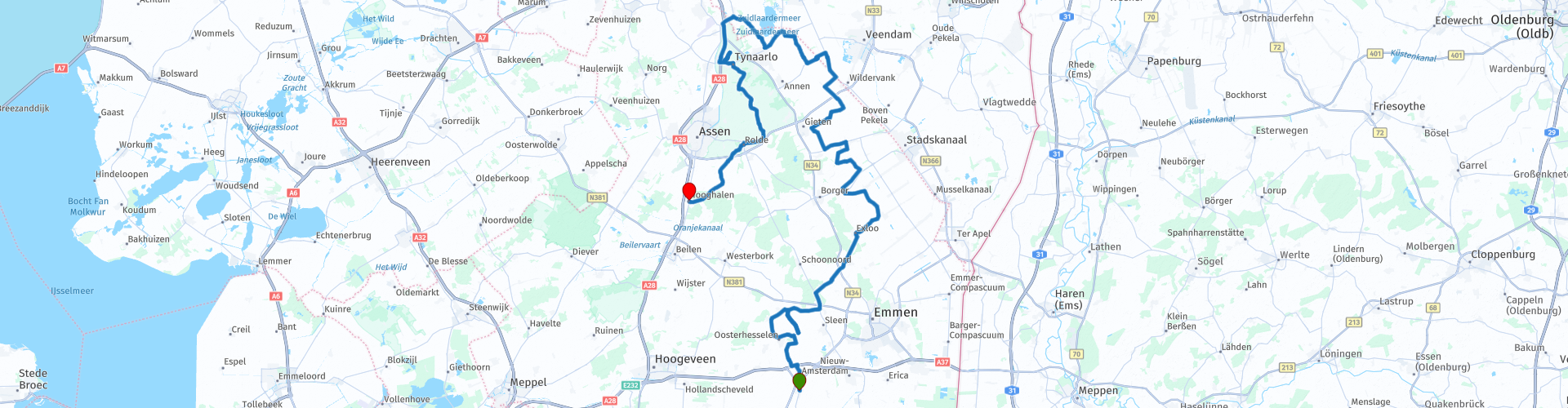
Winding through the Drenthe landscape you will arrive at De Driesprong in Gieterveen, time for coffee with something tasty. After coffee it continues along the meadows towards Glimmen, the northernmost point in the route, after which you descend towards Hooghalen. Just before the end point in Hooghalen you can visit the Camp Westerbork ** remembrance center.
** Camp Westerbork Remembrance Center is a museum where the history of Camp Westerbork is told. The museum is located on the Oosthalen road, about three kilometers from the former camp site. At the former camp site itself, motorized traffic and buildings are not allowed due to radio telescopes.
Because I have not (yet) driven this route myself, this route gets 3 stars.
Route details:
The route has been made the same for TomTom, Garmin and MyRoute-app Navigation users.
rp 1 - Start at Cafe-Restaurant Cornelis in Dalen
rp 5 - Photo opportunity at the Hunnenkerkhof
rp 26 - Coffee stop at the Driesprong in Gieterveen
rp 49 - Possibility to visit Camp Westerbork Memorial Center
rp 50 - End point at Scottish restaurant Het Wapen van Schotland in Hooghalen


 Links
Links  Usage
Usage Want to download this route?
You can download the route for free without MyRoute-app account. To do so, open the route and click 'save as'. Want to edit this route?
No problem, start by opening the route. Follow the tutorial and create your personal MyRoute-app account. After registration, your trial starts automatically.  Disclaimer
Use of this GPS route is at your own expense and risk. The route has been carefully composed and checked by a MyRoute-app accredited RouteXpert for use on TomTom, Garmin and MyRoute-app Navigation.
Changes may nevertheless have occurred due to changed circumstances, road diversions or seasonal closures. We therefore recommend checking each route before use.
Preferably use the route track in your navigation system. More information about the use of MyRoute-app can be found on the website under 'Community' or 'Academy'.