TTT 2015 02 Middelburg Grevelingen

This route was brought to you by:
RouteXpert Hans van de Ven (Mr.MRA)
Last edit: 26-12-2019
 Route Summary
 The 173 ANWB Promoter TankTasTocht (TTT) were scanned by Henry ten Dam and signed by Leon Stolk in Mapsource and later placed as a Track in a .gpx file. These are made available through the MrGPS website with the approval of the ANWB Promoter so that everyone can enjoy them. The 1st TTT is from 1992, so the route may differ slightly from the original.
I have checked all route points and, where necessary, placed them neatly on the road. Also, if necessary, I have further spaced the start point and end point of the route to avoid navigating directly to the end point and I added the POI files from the start and end point just like a possible stopping point.
Finally, I made the route the same for TomTom, Garmin and MyRoute-app Navigation users.
Thanks to Henry, Leon, MrGPS and Promoter.
 Share this route


Animation

Verdict


Duration
3h 31m

Mode of travel
Car or motorcycle

Distance
134.79 km

Countries

 RouteXpert Review
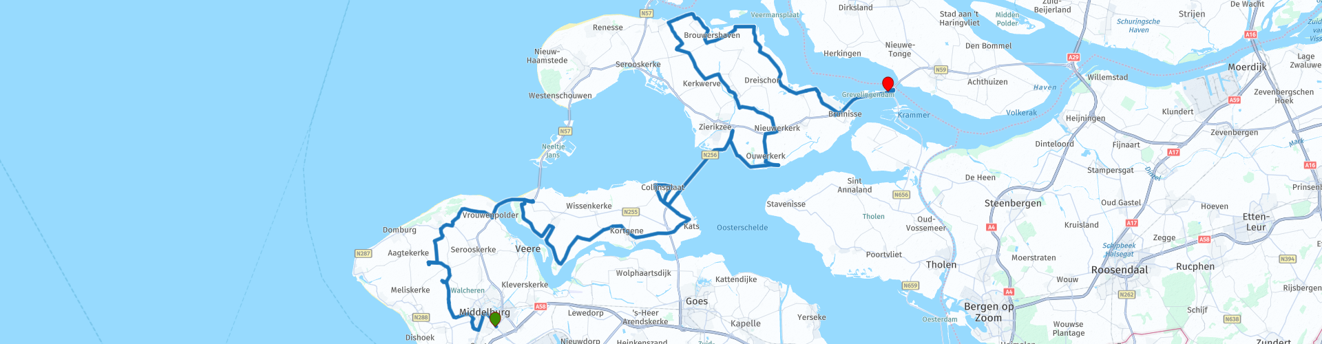
 After just fifteen minutes after leaving Middelburg, honey lovers can go to Imkereij Poppendamme, which has been a household name in Walcheren for 25 years. You will find the beekeeping shop, exhibition space and terrace here.
We drive on and after half an hour you pass the Veerse Meer, this is an artificial brackish water lake that was created by damming the Veerse Gat in the context of the Delta Works. Lake Veerse lies to the south of the island of Noord-Beveland, and to the north of Walcheren and Zuid-Beveland.
After another half an hour of driving through the Zeeland landscape you arrive at a nice place to take some pictures, the Goudplaat, is a Dutch nature reserve in the Veerse Meer. It was created because after the damming of the Veerse Gat the sandbar became dry, due to the loss of ebb and flow. It is managed by Staatsbosbeheer.
The coffee / lunch stop is scheduled on Colijnsplaat, where you can enjoy a treat while looking over the Oosterschelde.
After the stop, we go via the Zeeland Bridge (1965, initially Oosterschelde Bridge), this is a traffic bridge over the Oosterschelde with a total length of 5022 meters. He connects Noord-Beveland with Schouwen-Duiveland, thus ensuring a shorter connection between the towns of Vlissingen, Middelburg, Goes on the southern side, and Zierikzee, Bruinisse and Rotterdam on the northern side. To Schouwen-Duiveland where we visit the Watersnood Museum. Here you can hear the stories about the flood disaster of 1953, reconstruction, delta works and flood risk management.
After the stop we make a loop over Schouwen-Duiveland and then drive onto the Grevelingen dam, this is a Dutch dam between Schouwen-Duiveland and Goeree-Overflakkee. The dam is the fourth structure of the Delta Works. The construction of the 6 kilometer long dam began in 1958. On this dam is also the end point of the route at restaurant Grevelingen, where you can enjoy the TTT with a view of the Krammer. The Krammer is part of the Oosterschelde National Park.
Because I have driven this route myself, this route gets 5 stars.
Route details:
rp 6 - Imkereij Poppendamme
rp 12 - Veerse Meer
rp 15 - De Goudplaat
rp 21 - The Scheldt. - Coffee / lunch stop
rp 23 - Zeeland Bridge
rp 26 - Flood Museum
rp 45 - Grevelingen dam


 Links
Links  Usage
Usage Want to download this route?
You can download the route for free without MyRoute-app account. To do so, open the route and click 'save as'. Want to edit this route?
No problem, start by opening the route. Follow the tutorial and create your personal MyRoute-app account. After registration, your trial starts automatically.  Disclaimer
Use of this GPS route is at your own expense and risk. The route has been carefully composed and checked by a MyRoute-app accredited RouteXpert for use on TomTom, Garmin and MyRoute-app Navigation.
Changes may nevertheless have occurred due to changed circumstances, road diversions or seasonal closures. We therefore recommend checking each route before use.
Preferably use the route track in your navigation system. More information about the use of MyRoute-app can be found on the website under 'Community' or 'Academy'.