TTT 2016 03 Wassenaar Ursum

This route was brought to you by:
RouteXpert Hans van de Ven (Mr.MRA)
Last edit: 26-01-2020
 Route Summary
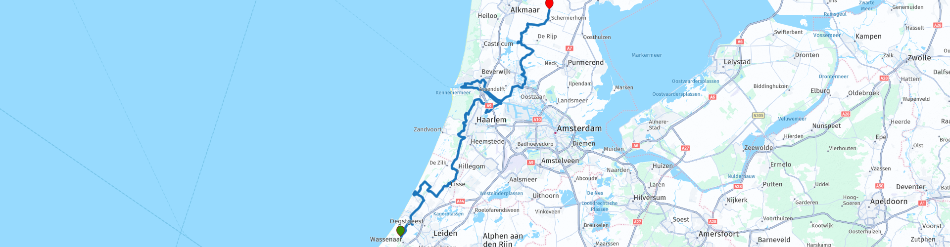
 This TTT are touring through the Netherlands with the occasional trip to Belgium, Germany or even Luxembourg, which are driven 6 to 7 times a year. The 1st around March and the last around October. These TTTs have a starting point, a pause location and an end point. It is nice to discover what you have not seen in your own country and which nice roads you did not know before.
This TTT is from 2016, so the route may differ slightly from the original.
I have checked all route points and, where necessary, placed them neatly on the road. Also, if necessary, I have further set the starting point and end point of the route a little further apart to prevent navigation to the end point directly and added the POI files of the start and end point, as well as possible pause location (s).
Finally, I made the route the same for TomTom, Garmin and MRA Navigation users.
Thanks to ANWB / Promoter.
 Share this route


Animation

Verdict


Duration
3h 11m

Mode of travel
Car or motorcycle

Distance
105.09 km

Countries

 RouteXpert Review
 In May it's great to drive in the Bollenstreek, so you can drive this route the best this month. You pass places like Noordwijk, Lisse, Bloemendaal and Spaarndam. Soon after the start, you drive between the bulbs, those delicious bulbs. It makes you speechless, enjoy the beautiful colors that you see along the way.
You can also take a picture of your motorcycle in Noordwijk aan Zee at the Wilhelmina monument. This is a Statue of Queen Wilhelmina and stands on the boulevard in Noordwijk aan Zee. The statue is made of bronze by the sculptor Kees Verkade. The statue is on a stone base that has been placed in a basin. The statue was donated in 2000 by the jubilating Hotels van Oranje to the municipality of Noordwijk. The monument was unveiled in May of that year by Erik Hazelhoff Roelfzema, formerly adjutant of the prince, who was assisted by Jos Mulder-Gemmeke.
The break is planned at Fort-Zuid in Spaarndam, Fort-Zuid, is a fort of the Stelling van Amsterdam. It is located southwest of Spaarndam-West, on the Noorder Buiten Spaarne. This fort was originally intended to defend Amsterdam against a potential attacker. Now you can eat there and / or rent a boat. All possibility to also take some nice pictures.
After the break it goes to Wormer and then to Cafe-Zaal De Rode Leeuw in Ursum where the end point of this TTT is.
Because I have not (yet) driven this route myself, this route gets 3 stars.
Route details:
rp 5 - Photo stop at the Wilhelmina Monument
rp 25 - Coffee / lunch stop at Fort-Zuid


 Links
Links  Usage
Usage Want to download this route?
You can download the route for free without MyRoute-app account. To do so, open the route and click 'save as'. Want to edit this route?
No problem, start by opening the route. Follow the tutorial and create your personal MyRoute-app account. After registration, your trial starts automatically.  Disclaimer
Use of this GPS route is at your own expense and risk. The route has been carefully composed and checked by a MyRoute-app accredited RouteXpert for use on TomTom, Garmin and MyRoute-app Navigation.
Changes may nevertheless have occurred due to changed circumstances, road diversions or seasonal closures. We therefore recommend checking each route before use.
Preferably use the route track in your navigation system. More information about the use of MyRoute-app can be found on the website under 'Community' or 'Academy'.