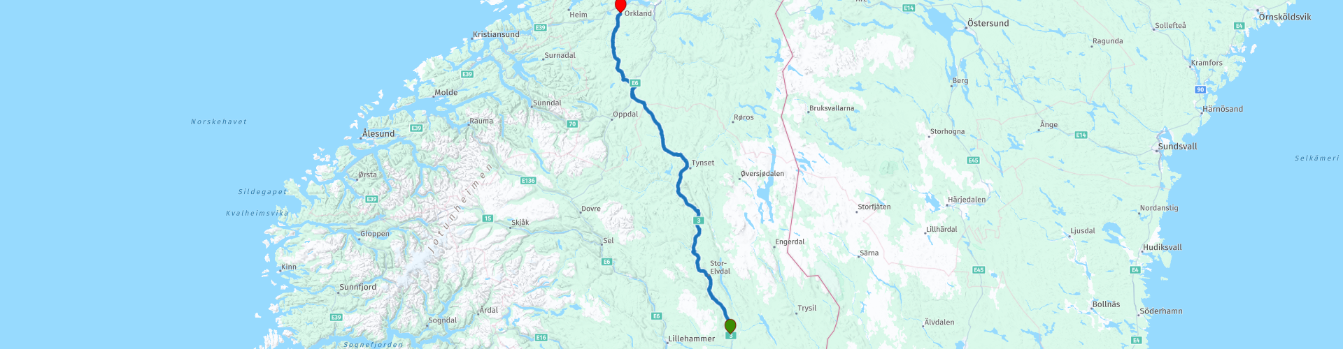
R05 Rena to Orkanger

This route was brought to you by:
RouteXpert Arno van Lochem - Senior RX
Last edit: 27-02-2021
 Route Summary
 The routes are easy for everyone to ride and are on well-paved roads. There may be a single hairpin bend to be taken, but these are fine.
If there is a piece of gravel in the route, a warning will be given and a detour will be indicated.
In this part of the tour you drive along the Glomma, Norway's longest river. You see endless forests and beautiful valleys, such as the Orkladal passing by. In that valley you can see in a museum how it used to be here. You will also pass the Orkla Industrial Museum where you can learn something about trains and mining.
The final destination is a hotel, but the camper has also been thought of, there are a number of campsites indicated where you can rent a hiker's cabin or camp.
Beautiful scenery, excellent roads and nice sights, hence the rating of 4 stars.
 Share this route


Animation

Verdict


Duration
7h 34m

Mode of travel
Car or motorcycle

Distance
306.06 km

Countries

 RouteXpert Review
 Of all western European countries, the Scandinavian countries probably have the most more or less untouched nature. In addition, they are countries that are easily accessible from the Netherlands. Norway is characterized by, among other things, the fjords and the Trollstigen known to many motorcyclists. And where Sweden is known as wide and relaxing, everyone knows Finland as the land of 1000 lakes. All in all, legitimate reasons to traverse this beautiful nature in the north of Europe by means of a number of routes.
The route starts in Rena, a small town located in central Norway. You start directly on National Road 3, a medium road that will take you further north. You drive directly along the Glomma, with a length of 621 kilometers the longest river in Norway. The catchment area of this river covers 13% of Norway, all in the southern part of the country.
The route then runs on the left bank, then again on the right bank. Every now and then a trip to the other side to just pass an attraction. In some places the road is much higher than the river, so if you can see the river, you have a beautiful view. This is the case, for example, with Garbekkegga. If you stop here and walk to the east you have a great view over the Glomma. Perfect place for a photo!
A few miles away, you'll spot a giant shiny moose, The Big Elk, also known as Storelgen (meaning 'big moose' in Norwegian), is the world's second tallest moose sculpture. The statue is an attempt to reduce traffic accidents by encouraging drivers to take a break and be aware of wildlife on the roads. The statue has a height of 10.3 meters, is made of polished stainless steel and cost a whopping € 200,000. All in all, well worth stopping and taking a look, if only to see if your hair is still in place.
After all this glitter, it's time for a cup of coffee. The first stop is planned at Glopheim Kafe. The cafe is decorated in true 1950s style - and stands out as the most authentic 1950s cafe in Norway. Here you will find a jukebox, black and white TV and a pinball machine, as well as items from the 50s. Great to enjoy a cup of coffee here in Happy Days style. Recommended!
The route meanders further along the Glomma, you now drive a bit on the east bank of the river. You will pass Jutulhogget Canyon, a place where you just have to take a look. That is, if you have no problems with gravel roads. To get there you have to drive about 500 meters on gravel. And back again of course, so a total of 1 kilometer. Your visit will be rewarded with the view over a beautiful piece of nature. The largest canyon in Northern Europe, which was formed during the last Ice Age about 10,000 years ago. You can experience the Jutulhogget Canyon on foot by descending the steep trail, or you can enjoy the view from the rim.
In Alvdal it is time for lunch, you can choose from a number of restaurants, there is bound to be something to your liking. Close to the restaurants, you'll also come across Aukrustsenteret, a museum built to house the life's work of multi-artist Kjell Aukrust. Visit this beautiful building and experience Aukrust's drawings, paintings, figures and humorous imaginative invention.
After lunch you drive further north and after about 25 kilometers the route bends off the Glomma, you will not see it again today. A few dozen kilometers further, however, you drive along another river, the Orkla. This river is shorter than the Glomma, but at 180 kilometers it is the longest in the province of Trøndelag. It flows through the Orkla valley and eventually flows into the Orkdslsfjorden, close to Orkanger.
In the last 30 kilometers of the route you will pass two museums. The first is the Orkla Industrimuseum. If you like technology you should take a look here. The museum has the oldest AC-powered railway still in operation, the Thamshavn railway. They still run with carriages that were delivered at the opening of the railway in 1908. You can also visit an old mine. So dress up as a miner, including helmet with lamp, and go down!
More than 5 kilometers further you will find the exit to Orkdal Bygdetun. This museum offers you a walk through the rural history of the Ork Valley. Nice to see. The road to it is made of gravel and has a length of approximately 6 kilometers one way.
The route ends at Hotel Vertshuset Fannarheimr in Orkland. A simple and inexpensive hotel, equipped with a bar and a restaurant. In the evening, the route can therefore be evaluated again while enjoying a drink.
Three campsites are indicated for campers in the vicinity of the end point: Kvåles Kro og Ridesenter, Follo Camping and Orkla Gjestegård
Have fun driving this route!


 Links
Links  Usage
Usage Want to download this route?
You can download the route for free without MyRoute-app account. To do so, open the route and click 'save as'. Want to edit this route?
No problem, start by opening the route. Follow the tutorial and create your personal MyRoute-app account. After registration, your trial starts automatically.  Disclaimer
Use of this GPS route is at your own expense and risk. The route has been carefully composed and checked by a MyRoute-app accredited RouteXpert for use on TomTom, Garmin and MyRoute-app Navigation.
Changes may nevertheless have occurred due to changed circumstances, road diversions or seasonal closures. We therefore recommend checking each route before use.
Preferably use the route track in your navigation system. More information about the use of MyRoute-app can be found on the website under 'Community' or 'Academy'.