Day 12 North Cape Tour Alta Skarsvag

This route was brought to you by:
RouteXpert René Plücken (MRA Master)
Last edit: 23-01-2026
 Route Summary
 You drive longer distances in Norway without encountering a gas station or restaurant, keep this in mind before you drive. Make sure your tank is full and bring food and drinks. Bring a few bottles of water or Camel bag and fill it up when you stop to refuel. A number of breaks are scheduled along the way for refueling, eating and drinking.
You have the choice to stay overnight at campsites or in hotels. Hotel prices in Norway are not particularly high and breakfast is usually included. Camping is free almost everywhere, except on private property or where camping is prohibited, indicated by prohibition signs. If you don't want to camp, there are often cabins for rent on the campsites. For a trip through Norway it is always advisable to bring a tent and other camping gear.
I rate this route with 5 **** stars because of the roads and beautiful views. It is a drive of about 150 miles and there are no sights to visit along the way, but our highlight is the North Cape!
 Share this route


Animation

Verdict


Duration
9h 21m

Mode of travel
Car or motorcycle

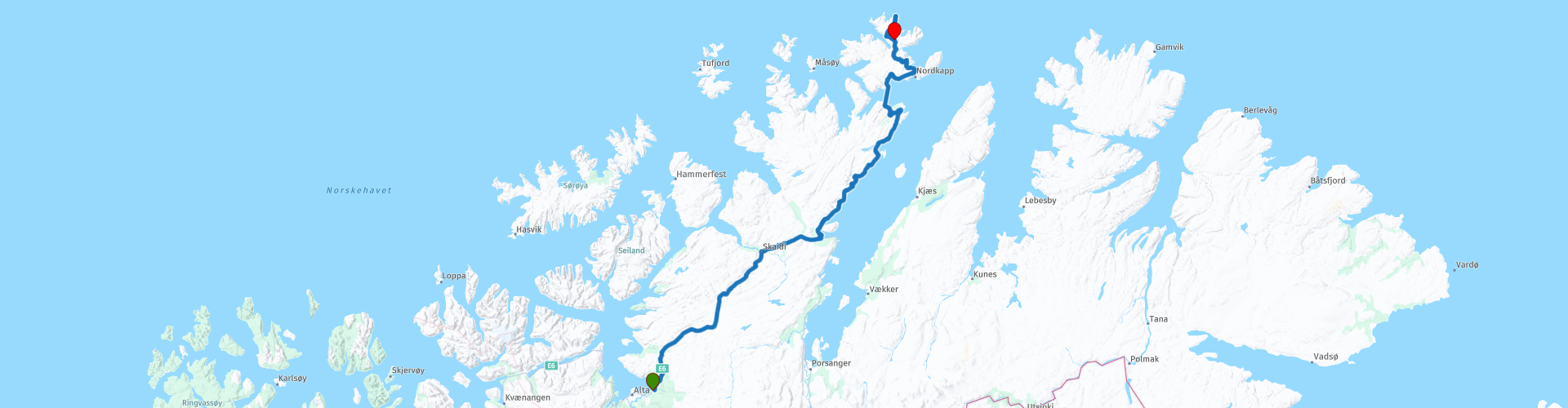
Distance
238.49 km

Countries

 RouteXpert Review
 Today we'll be driving mostly without long stops, as there aren't many sights along the way. We'll stop at the COOP supermarket for some groceries to ensure we have enough food and drinks; there aren't many places to buy things along the way.
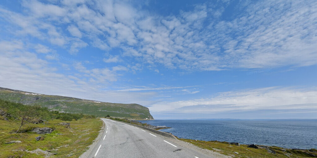
We're driving north on the E6. This two-lane provincial road is in excellent condition, and along the way you can enjoy beautiful views. There are plenty of parking areas along the way, the larger ones also having restrooms. The route has beautiful, well-defined bends, but unfortunately also long, somewhat boring straight stretches. Fortunately, the stunning panoramas more than make up for it.
In Skaidi, there are opportunities to refuel, shop for groceries, and have a drink. Lunch is planned for Olderfjord at Russenes Kro restaurant. Previously, the North Cape was only accessible by ferry, but since 1999, several tunnels have opened, making it easily accessible.
The first tunnel we take is the Skarvberg Tunnel. This is a 2,920-meter-long, single-tube tunnel located along the Porsangerfjord. The tunnel cuts through a mountain ridge approximately 300 meters high, about 18 kilometers north of the intersection between the E6 and E69 highways. The tunnel is toll-free.
The next tunnel is the North Cape Tunnel (Norwegian: Nordkapptunnelen). Stop here to take a photo at the entrance to one of Norway's longest and northernmost submarine road tunnels. The tunnel takes us under the Magerøysundet strait, between the Norwegian mainland and the large island of Magerøya. The tunnel was built between 1993 and 1999, along with the Honningsvåg Tunnel. These tunnels connect mainland Norway with the town of Honningsvåg and the tourist attraction at North Cape. The North Cape Tunnel was officially opened by King Harald V of Norway on June 15, 1999. The tunnel is 6,875 meters long and reaches a depth of 212 meters below sea level.
Ten kilometers further on, we arrive at the Honningsvåg Tunnel (Honningsvågtunnelen). This 4,443-meter-long tunnel runs through the Honningsvågfjellet mountain, west of the city of Honningsvåg. The tunnel is 9 meters wide and has two lanes, one in each direction. It is the northernmost public road tunnel in the world.
We continue along the beautiful, winding E69 towards the North Cape (Norwegian: Nordkapp; Northern Sami: Davvenjárga). Along the way, we can buy souvenirs made by the locals.
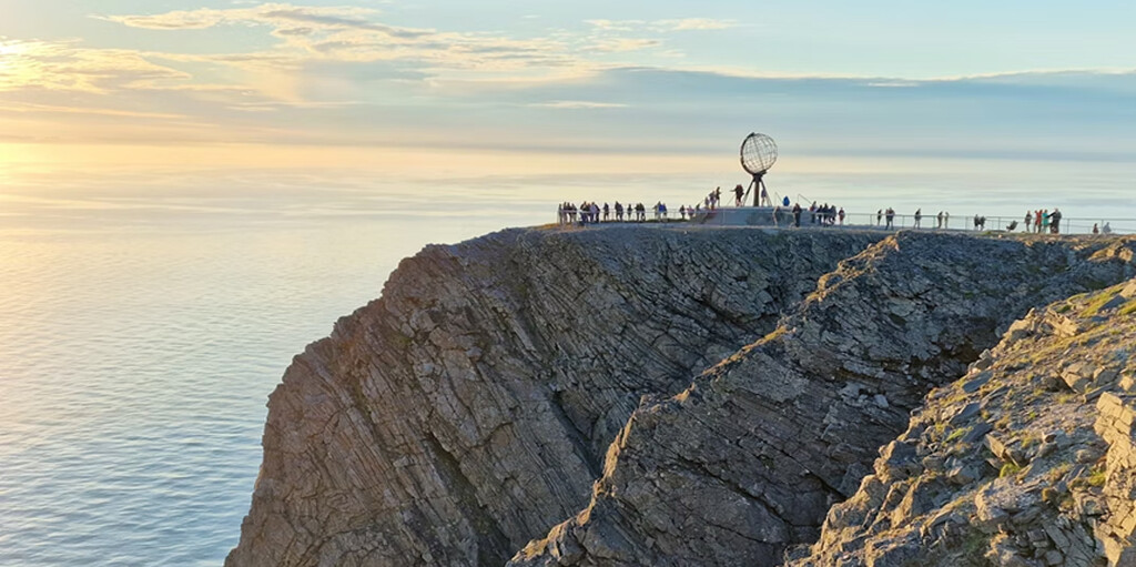
The North Cape is the final destination of this 12-day round trip. It's a cape on the north coast of the island of Magerøya, in Northern Norway, and is located in the municipality of Nordkapp in Troms og Finnmark county.
The European highway E69 has its northern terminus at North Cape. This makes it the northernmost point in Europe accessible by car, and the E69 the northernmost public road in Europe. The plateau is a popular tourist attraction. The cape consists of a 307-meter-high cliff topped by a large, flat plateau where, weather permitting, visitors can see the midnight sun and enjoy views of the Barents Sea. Located on the plateau is North Cape Hall, a visitors' center opened in 1988. The center features a café, restaurant, post office, souvenir shop, a small museum, and a cinema.
At the end of the day we drive back to Skarsvåg, where we spend the night at one of the campsites.
 Links
Links  Usage
Usage Want to download this route?
You can download the route for free without MyRoute-app account. To do so, open the route and click 'save as'. Want to edit this route?
No problem, start by opening the route. Follow the tutorial and create your personal MyRoute-app account. After registration, your trial starts automatically.  Disclaimer
Use of this GPS route is at your own expense and risk. The route has been carefully composed and checked by a MyRoute-app accredited RouteXpert for use on TomTom, Garmin and MyRoute-app Navigation.
Changes may nevertheless have occurred due to changed circumstances, road diversions or seasonal closures. We therefore recommend checking each route before use.
Preferably use the route track in your navigation system. More information about the use of MyRoute-app can be found on the website under 'Community' or 'Academy'.