03 Paihia to Pukenui

This route was brought to you by:
RouteXpert Nick Carthew - (MRA Master)
Last edit: 03-02-2021
 Route Summary
  Share this route


Animation

Verdict


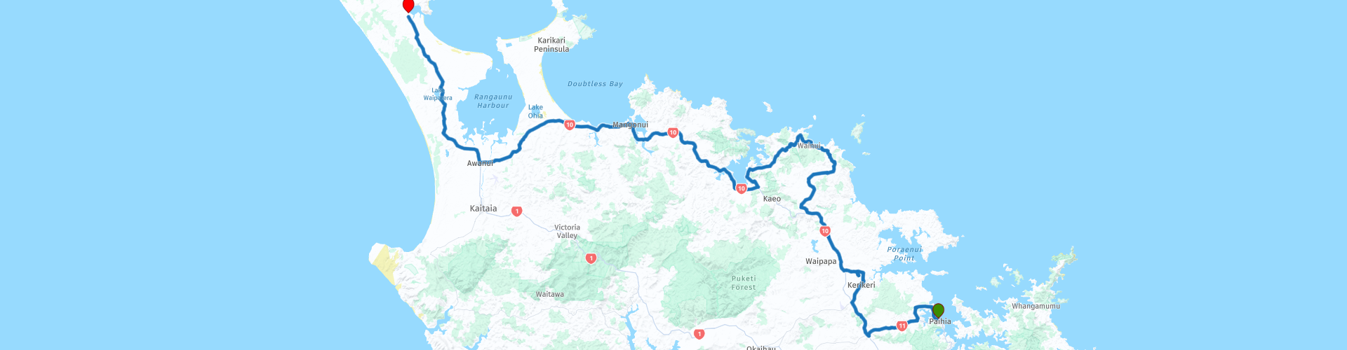
Duration
5h 56m

Mode of travel
Car or motorcycle

Distance
181.54 km

Countries

 RouteXpert Review
 Today's route starts by visiting the Waitangi Treaty Grounds, New Zealand’s most important historic site.
Explore two new contemporary museums:
Te Rau Aroha, the theme of this museum’s main exhibition is the "Price of Citizenship" (Te Utu o Te Kiriraraunga). It tells the story of the Māori commitment to the armed forces including the Boer War and both World Wars.
Te Kōngahu Museum of Waitangi: The signing of Te Tiriti o Waitangi, Treaty of Waitangi
You will be taken on a journey through historical moments as they happened – leaving the museum encouraged to reflect on what the Treaty means today. Entry to the permanent exhibition is via an impressive foyer and begins with a traditional Māori karanga (call of welcome).
The Carving Studio: Carving is a celebrated expression of both storytelling and art in Māori culture. Whare Toi, the Carving Studio at Waitangi provides a unique opportunity to meet traditional carvers (kaiwhakairo).
The Treaty House: The Treaty House, or Busby House as it is sometimes known, was the site of some of the most important events in New Zealand’s history. The first flag for the nation was chosen here in 1834; the 1835 Declaration of Independence was drafted in the house by James Busby and presented to the northern chiefs; and the Treaty of Waitangi was given its finishing touches here before being read to the chiefs on 5 February 1840. The original Treaty House was pre-cut in Sydney out of Australian hardwood and shipped to New Zealand for assembly on site in 1834. The building provided a home for the official representative of the British Government in New Zealand.
Te Whare Rūnanga (Carved Meeting House): Te Whare Rūnanga (the House of Assembly) is a beautifully carved meeting house designed in traditional Māori form and built from timber and other natural materials. The meeting house was opened on 6 February 1940 and stands facing the Treaty House on the Upper Grounds of Waitangi. Together the two buildings symbolise the partnership between Māori and the British Crown on which the nation of Aotearoa New Zealand is founded.
Te Korowai ō Maikuku (waka house) near Hobson’s Beach shelters a ceremonial war canoe named Ngātokimatawhaorua, the world’s largest of its type. Waka have always played a vital role in Māori culture, essential for travel and uniquely constructed and carved as symbolic representations of each iwi’s (tribe’s) identity and spirituality.
Ngātokimatawhaorua was built to mark the centenary of the Treaty of Waitangi’s signing in 1940 and was built by members of New Zealand’s northern and Waikato tribes. The waka is launched every year in February as part of Waitangi Day celebrations.
Leaving the Treaty Grounds and picking up a short gravel road to take you to Mt Bledisloe Lookout. This viewpoint offers you views back to Paihia and beyond to the Bay of Islands. There is a handsome ceramic marker at the top showing the distances to major world cities. It was made by Royal Doulton in London and presented by Lord Bledisloe in 1934 during his term as governor-general of New Zealand. A little further on, just after the end of the gravel road, you will find the Haruru Falls. Haruru Falls is a small but wide waterfall. It's where the Waitangi River is at its strongest, feeding into a significant lagoon that ebbs its way out to the Bay of Islands.
There is a McDonald's (and other) coffee stop 20 minutes from here at Kerikeri RP 11.
A short distance from here at RP 13 are the Angel Falls, Māori name Waianiwaniwa, (Waters of the Rainbow), this is a single, 27 m drop waterfall. Unlike most NZ waterfalls which are created by the erosion of soft rock, the Rainbow Falls are sited on a hard basalt layer of rock beside softer mudstone. The falls were formed when water eroded the mudstone.
Rejoin State Highway 10 (SH10) at Waipapa and continue north through a landscape of rich pasture and woodland through rolling hills. Turn right at RP 14 and head for Matauri Bay.
At RP 15, there is a great view towards Motukawanui Island, the largest of the Cavalli Islands. On the seafloor between the Cavalli Islands and Matauri Bay lies the Rainbow Warrior, the famous Greenpeace vessel. The ship was involved in protests against the French government, which was undertaking nuclear tests in French Polynesia during 1985. The Rainbow Warrior was sunk by the French intelligence service while at anchor in New Zealand that same year, causing national outrage.
Take the turning on the right before RP 15 for Matauri Beach to see the Rainbow Warrior Memorial.
The road back to the SH10 takes you through the Tauranga Valley Scenic Reserve on a bitumen surface that twists and turns and offering views to the coast from its elevated position, a truly stunning road.
I have suggested a lunch stop at RP 20 Mangonui. There's a fabulous Café here called Little Kitchen. They offer fantastic coffee and delicious homemade food. Dine alfresco while taking in the views of Mangonui Harbour.
At RP 22 there is a museum called Matthews Vintage Collection. Here you'll find a great collection of vintage cars, tractors and agricultural equipment, enough to satisfy any mechanically minded tourist. The end of the route is one hour from here.
At Awanui, I have suggested a fuel stop before you head onto the Aupouri Peninsula as there are not many fuel stops beyond here.
The Aupouri Peninsula is a tombolo (sandy isthmus). Tombolo, from the Italian tombolo, meaning 'pillow' or 'cushion'. This seems rather apt as the peninsular is at the head of NZ. This is the region where the majority of Māori people live and should not be missed. The Māori call it Te Hiku o Te Ika ("the tail of the fish"), because the Māori name for North Island is Te Ika A Maui ("the fish of Maui"). This whole region is strongly marked by Polynesian traditions and its legends fascinate as much as its beauty dazzles.
The route ends at Pukenui where there's a good choice of accommodation, I have included links for four different types below this review. Tomorrow's route takes you to Cape Reinga, a sacred site for Māori people.
Enjoy.


 Links
Links  Usage
Usage Want to download this route?
You can download the route for free without MyRoute-app account. To do so, open the route and click 'save as'. Want to edit this route?
No problem, start by opening the route. Follow the tutorial and create your personal MyRoute-app account. After registration, your trial starts automatically.  Disclaimer
Use of this GPS route is at your own expense and risk. The route has been carefully composed and checked by a MyRoute-app accredited RouteXpert for use on TomTom, Garmin and MyRoute-app Navigation.
Changes may nevertheless have occurred due to changed circumstances, road diversions or seasonal closures. We therefore recommend checking each route before use.
Preferably use the route track in your navigation system. More information about the use of MyRoute-app can be found on the website under 'Community' or 'Academy'.