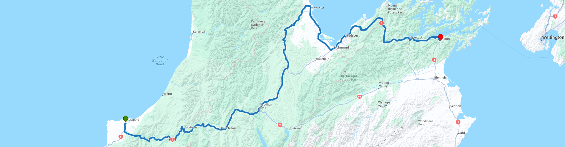
09 Westport to Picton

This route was brought to you by:
RouteXpert Nick Carthew - (MRA Master)
Last edit: 12-01-2023
 Route Summary
 This route travels through several inland scenic reserves including the beautiful Upper and Lower Buller Gorge reserves. It passes hop fields, orchards of kiwi fruit and vineyards before reaching the 'Top of the South'.
Between Havelock and Picton, a 35 km winding road fringed with native forest offers one of the most scenic coastal drives that you're likely to encounter. Make sure you leave enough time to make plenty of stops along the way.
Excellent scenery and roads have earned this, the final route of the South Island tour, 5***** stars.
I know that you will have enjoyed this tour and I will be grateful to hear your comments. Enjoy.
 Share this route


Animation

Verdict


Duration
9h 10m

Mode of travel
Car or motorcycle

Distance
385.83 km

Countries

 RouteXpert Review
 Leaving Westport with a full tank of fuel, you'll follow the mighty Buller River for 132 km, mostly through the Lower and then the Upper Buller Gorge Scenic Reserves, some of the most exciting and scenic driving anywhere.
The Buller Gorge is one of New Zealand's scenic wonders that should be added to your "must see" list. A remarkable landmark located in the Lower Buller Gorge is Hawks Crag. It's a narrow piece of road carved out of an overhanging rock face. With the mighty Buller River sometimes thundering below it. The cliff at Hawks Crag is almost vertical, which certainly created a challenge when constructing a road through it in 1869. The Kilkenny Lookout offers great views of Hawks Crag.
The Upper Buller Gorge starts at the small settlement of Inangahua Junction where the Inangahua River joins the Buller.
From its source at Lake Rotoiti, the Buller River cuts a westward course to reach the Tasman Sea at Westport. The scene of floods, earthquakes, and home to hundreds of transient workers during gold mining times, the Gorge has been a challenge to horsemen, coach drivers, roadmakers and bridge builders.
Maori travellers used the river as a highway and helped early European explorers and goldminers to negotiate the treacherous rapids. today’s road travellers can take time to enjoy the scenery and features between Murchison and Inangahua in a split fraction of the seven weeks it took Thomas Brunner to make the journey in 1847.
Buller Gorge Swingbridge is well signposted and a good place to stop and view the Buller on New Zealand’s longest swingbridge. At 110 m long and suspended 19 m above the mighty Buller River it offers a great vantage point for photos.
I've suggested a coffee stop at Murchison. Murchison is known as the ‘whitewater capital’ of the country, because there are rivers everywhere – the Gowan, Mangles, Matiri, Glenroy, Matakitaki, Maruia and the mighty Buller. There's also a good choice of cafes to choose from.
After another 30 km, it's time to say farewell to the Buller and follow the Hope River to Glen Hope after which the road gradually climbs to Hope Saddle, the highest point of the route at 634 m. A short pathway takes you to a lookout with 360° views of the surrounding hills and mountains.
I haven't mentioned that for the third day running, this tour is using State Highway 6 and just after using the Kohatu Bridge to cross over the Motueka River you have a choice of staying on the SH6 and rejoining this route at Richmond or turn left onto the Motueka Valley Highway and head to Motueka for a lunch stop. Staying on the SH6 will save you one hour of travel time plus lunch.
The Motueka Valley Highway is a delightful road that passes through orchards and vineyards growing apples, pears, kiwi fruit, hops and grape vines. Hops are the dried, flowering part of the hop plant. They are commonly used in brewing beer and as flavoring components in foods. Hops are also used to make medicine.
Motueka.
Motueka is a vibrant town, known for its lively café culture and artistic community making it a great place for lunch. Over the harvest months, Motueka is a busy town. The local pip fruit and hops growers employ seasonal labour which swells the population, and many visitors use the town as a supply point for explorations of the Abel Tasman and Kahurangi National Parks. The town center and the Sunday Market are a showcase of the regions arts and artisans, with boutique stores and craft stalls spread amongst small cafes, restaurants and food carts, serving up homegrown produce and local fare.
For the adventurous, a scenic skydive offers mind-blowing views of the North and South Islands, and three national parks. Or, if you prefer to keep your feet planted firmly on the ground, a stroll along the waterfront to see the iconic Janie Seddon Shipwreck, a dip in the Motueka Saltwater Baths or a short walk to the Riwaka Resurgence, where the river emerges from a marble cave. If you wanted to extend your tour, then two nights at Motueka is recommended leaving a short 2½ run into Picton.
After lunch and re-filling with fuel, the route follows the shore of Tasman Bay and rejoins the SH 6 at Richmond and then through the city of Nelson in the region of Tasman. Often known as ‘the top of the south’, Nelson Tasman takes up the northwestern corner of the South Island. With an ideal growing climate, Nelson produces all of New Zealand’s commercial hops and has consequently become the country’s craft brewing capital with 11 craft breweries, while the region’s 25 boutique wineries excel at producing aromatic wines and chardonnay. Other horticultural stand-outs include apples and berries, while the ocean’s produce has made Port Nelson the largest fishing port in Australasia.
Not long after leaving Nelson behind you, SH6 takes you through the Wakapuaka River valley on an incredibly twisty section of road. Logging is the main industry here and you'll probably pass complete hillsides that have been clear felled for their timber.
I've suggested another coffee stop at Pelorus Bridge Cafe. Peter Jackson chose Pelorus Bridge as a filming location for scenes from The Hobbit: The Desolation of Smaug. Here, the dwarves were filmed floating in barrels down the river - an experience that Stephen Hunter, who played dwarf Bombur, called 'his favourite day on set'! No doubt because of the stunning landscape.
The town of Havelock is next and this is where you say a final farewell to the SH6 after travelling on this superb road for nearly 1000 kms. Don't be too upset though the final road to take you to Picton; Queen Charlotte Drive will not disappoint.
Between Havelock and Picton, a 35 km winding road fringed with native forest offers one of the most scenic drives you're likely to encounter. Near the Havelock end of the road, a sign simply says 'lookout'. Rural New Zealanders are known for their modest understatement and this sign is living proof of that tendency. The view out across the sounds from this spot at Cullens Point is an image that will stay with you for many years - it's breathtaking.
Queen Charlotte Drive continues downhill to wind past numerous sleepy bays. The strong arts and crafts community in this area means there are several opportunities to pause and browse art studios for a special memento or two.
Through the area of Linkwater, the road passes along a low saddle. You're now traversing five kilometres of land between the head of Pelorus Sound and the head of Queen Charlotte Sound. To achieve the same thing by boat involves travelling more than a 100 km out to the open sea and back in again - little wonder early farmers considered putting a canal through here.
Continuing around the upper reaches of Queen Charlotte Sound you'll pass The Grove and sheltered Momorangi Bay before climbing the headland that leads into the seaside town and ferry port of Picton.
This route and the tour of South Island ends here at Picton. There is a very good choice of accommodation and I have included a selection in the links below as well as a link for the Bluebridge Cook Strait Ferries to take you to North Island where you can resume the North Island tour that's in the MyRoute-app RouteXpert library or available here: https://www.myrouteapp.com/en/info/collection/135/A-complete-tour-of-North-Island-New-Zealand-from-Auckland?fbclid=IwAR03hlD8JEtoIHGUEZ6KQdjJ6SaKvFssRmSH3vZlpSLJIb9a1C0OryXhGPI
Enjoy.


 Links
Links  Usage
Usage Want to download this route?
You can download the route for free without MyRoute-app account. To do so, open the route and click 'save as'. Want to edit this route?
No problem, start by opening the route. Follow the tutorial and create your personal MyRoute-app account. After registration, your trial starts automatically.  Disclaimer
Use of this GPS route is at your own expense and risk. The route has been carefully composed and checked by a MyRoute-app accredited RouteXpert for use on TomTom, Garmin and MyRoute-app Navigation.
Changes may nevertheless have occurred due to changed circumstances, road diversions or seasonal closures. We therefore recommend checking each route before use.
Preferably use the route track in your navigation system. More information about the use of MyRoute-app can be found on the website under 'Community' or 'Academy'.