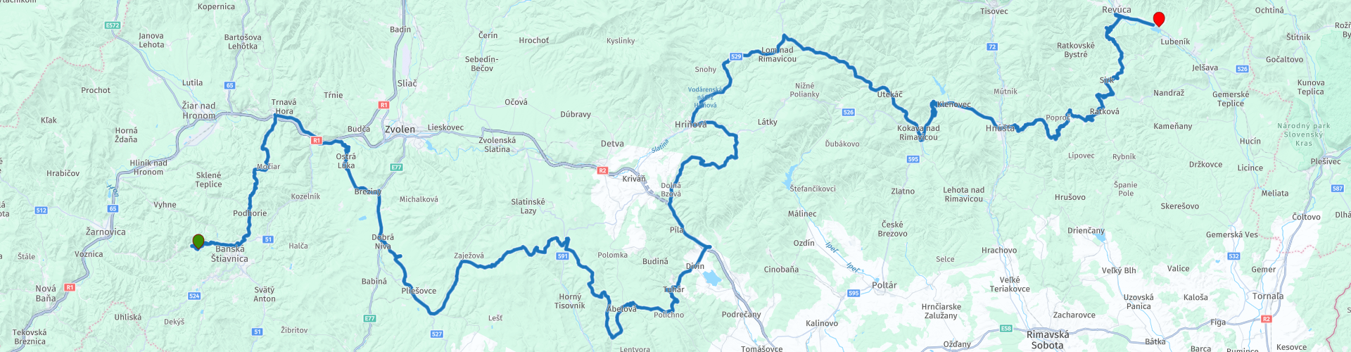
02 from Banska Stiavnica to Revucka Lehota via Polana Nature Park

This route was brought to you by:
RouteXpert Leonor Orban - Sr. RouteXpert
Last edit: 11-05-2021
 Route Summary
 You usually drive through forest areas again. From time to time the forests open up, so you have a beautiful view of the area around you. Again, you will visit a special nature reserve (Poľana), which also marks the highest point of the route: 1015m. This is the only time that you will exceed 1000m, but the altimeters are nevertheless no less. The entire route you ascend and descend on various winding roads to your final destination.
Along the way you have the option to stop at a number of special places. Of course a number of castles are on your list (Dobrá Niva and Divín). And in addition to the nature reserve of Poľana, you will also visit Gavurky Natural Reserve, with its centuries-old oak trees.
It is yet another day of enjoyment. The heart of Slovakia is a real pleasure to travel around. There is plenty to see and experience, you can stop regularly for photos. Unfortunately, the range of restaurants along the route is less, and the roads along the way are not always of good quality. Hence, the route gets 4 stars instead of 5.
 Share this route


Animation

Verdict


Duration
8h 47m

Mode of travel
Car or motorcycle

Distance
242.79 km

Countries

 RouteXpert Review
 Hopefully your stay with Chata Hodruša has done you good. After a quiet night along the lake, between the mountains, another day full of stimuli begins.
The morning starts with a winding road through the Štiavnické mountains. A nice start to warm up the engine. You can also refuel in Banská Štiavnica.
From here you take a smaller road North, towards the Hron river. You avoid the crowds and have ample opportunity to practice your cornering technique, as this road does not seem to have a straight stretch. Once back down in the valley, the Rhon leads you to Ostrá Lúka. This small village in the hills offers an insight into the traditional way of life and culture of the Slovak people. The castle of the noble Ostrolúcky is not open for visits, but a short walk around the castle and through the village - after an hour - drive might be a nice option to stretch your legs.
The route continues towards the Gavurky nature reserve. On the way you will first see the ruin of the Dobrá Niva castle, just before the village of Podzámčok, on the left side of the hill. You will also pass through the town of Dobrá Niva. You can pause here at the local pizzeria or postpone your break until Gavurky's visit (and that's a must!). In Dobrá Niva you can do your shopping at the local supermarket and then enjoy a lovely picnic. The Gavurky nature reserve is known for its centuries-old oak trees. You can park relatively close to the forest and from there look for a nice place for your picnic. With a beautiful view, in the shelter of the old trees, you can relax before you set off again. Don't forget to bring your waste!
After this break, the route winds further East, this time with a wide arc around the military training area of Lešť. On the way you will see few warning signs for this area, but a military vehicle accidentally passing by will alert you to where you are. Hence the advice not to deviate from the route here.
After about 4 hours on the road you will arrive in Divín. At the top of the hill, in the center of the village, are the remains of Divín Castle (not to be confused with the ruins of Devin Castle, your starting point on route 1). Like many of the castles in Slovakia, this castle was built in the 13th century and served as a fortress against the rising Turks in the 16th century. You can walk up and visit the ruin. Keep in mind that the walk upwards takes about 15 minutes. In the village you can also take a break at a local snack bar. Alternatively, you can also stop at a restaurant in the next village c
Small winding roads through the woods are interspersed with more continuous (and better asphalted) roads towards the Poľana nature reserve. This area is home to a number of modest mountain peaks of which the highest (around 1500m) is an inactive stratovolcano. For now we only drive past it. Here and there you can stop to enjoy the views, such as a reservoir.
Keep in mind that the road surface is not always of the same good quality! As a result, your average speed will not always be the same; and it is probably also pleasant to recover from all the bumps and potholes at Koliba Studienka. This cozy wooden chalet offers a choice of snacks and drinks to energize the last leg of the route.
Soon after, a real climb over a mountain pass (Chorepa) starts with a few beautiful hairpin bends. These are the advance for what is to come next: a stretch with endless curves and hairpin bends. The road here is wide and well paved, so you can enjoy yourself.
At about 15 km before the end of the route it gets spicier: "the sting is always in the tail". You are diverted from the main road from route point 25. This narrow, sometimes poorly paved, road takes you to Revúca. along the way you sometimes encounter very tight corners, worth using all your technical skills to get through. The reward is certainly no less: it is a spectacular piece to drive and also offers some beautiful moments from beautiful perspective to photograph your fellow travelers.
Are you tired after a long day of driving and you don't want to be difficult anymore? Then it is best to deviate from the route at route point 25 and follow the main road to Revúcka Lehota. When you arrive at the T-junction, turn left. After about 500m you can turn left towards the lake and Penzion Flipper, the end of your route.


 Links
Links  Usage
Usage Want to download this route?
You can download the route for free without MyRoute-app account. To do so, open the route and click 'save as'. Want to edit this route?
No problem, start by opening the route. Follow the tutorial and create your personal MyRoute-app account. After registration, your trial starts automatically.  Disclaimer
Use of this GPS route is at your own expense and risk. The route has been carefully composed and checked by a MyRoute-app accredited RouteXpert for use on TomTom, Garmin and MyRoute-app Navigation.
Changes may nevertheless have occurred due to changed circumstances, road diversions or seasonal closures. We therefore recommend checking each route before use.
Preferably use the route track in your navigation system. More information about the use of MyRoute-app can be found on the website under 'Community' or 'Academy'.

Bansk Bystrica
About this region
2. liga, currently named DOXXbet liga due to sponsorship reasons, is the second-highest division in the Slovak football league system after the Fortuna Liga. The 2016–17 season of the DOXXbet liga will be the 24th season of the second-tier football league in Slovakia, since its establishment in 1993.
For the third time in history (and for now for the last time), teams will compete in two groups, with top six sides from each of groups will advance to the championship round and all other teams will play in relegation groups. From the 2017–18 season, 2. Liga will feature 16 teams playing in nationwide group.
Read more on Wikipedia
For the third time in history (and for now for the last time), teams will compete in two groups, with top six sides from each of groups will advance to the championship round and all other teams will play in relegation groups. From the 2017–18 season, 2. Liga will feature 16 teams playing in nationwide group.
View region
 Statistics
  6
6Amount of RX reviews (Bansk Bystrica)
 7653
7653Amount of visitors (Bansk Bystrica)
 300
300Amount of downloads (Bansk Bystrica)
 Route Collections in this region
 9 day tour through Slovakia
Adventure, discover and experience. This is how you could describe this route collection.
The 9-day trip through Slovakia gives a nice picture of the wealth of this young independent republic. The largely mountainous country is home to beautiful national parks, UNESCO heritage sites, mysterious castles and dark caves. This collection gives you the opportunity to visit a selection of this diversity of nature and culture.
Motorcyclists will experience that Slovakia has wonderfully winding roads… and that you can still travel adventurously. Some roads are unpaved and therefore offer a nice challenge.
Not only the winding roads are mouth watering. The countless restaurants with delicious local specialties will also bring about a lot!
View Route Collection