D10 Colville Wenatchee

This route was brought to you by:
RouteXpert Hans van de Ven (Mr.MRA)
Last edit: 02-05-2021
 Route Summary
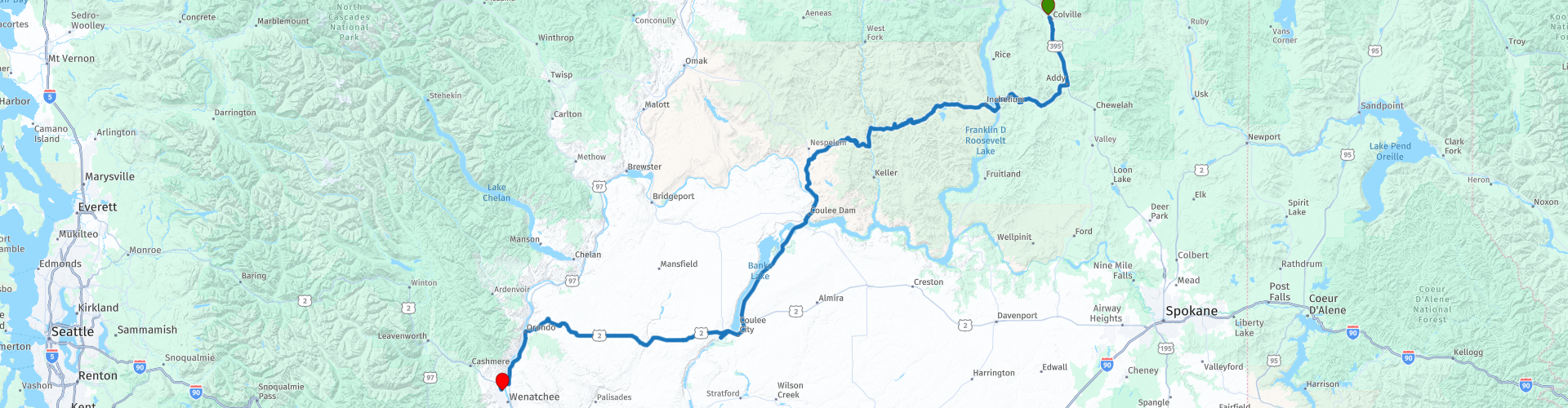
 Starting point: Comfort Inn Colville
End point: Best Western Chieftain Inn
The route has been made the same for TomTom, Garmin and MyRoute-app Navigation users.
Thanks to Richard & Lisa for the information!
 Share this route


Animation

Verdict


Duration
8h 15m

Mode of travel
Car or motorcycle

Distance
335.02 km

Countries

 RouteXpert Review
 The Colville Indian Reservation is an Indian reservation in the north-central part of the US state of Washington, inhabited and managed by the Confederated Tribes of the Colville Reservation, which is federally recognized. The reserve was established in 1872 and currently consists of 2,825,000 hectares (1,143,000 ha). It is mainly in the southeastern part of Okanogan County and the southern half of Ferry County, but it includes other areas of trustland in eastern Washington, including in Chelan County, just northwest of the city of Chelan.
The name of the reserve is derived from that of Fort Colville, which was named by British settlers after Andrew Colville, a London governor of the Hudson's Bay Company.
The tribes have 8,700 descendants of 12 indigenous tribes. The tribes are known in English as: the Colville, Nespelem, Sanpoil, Lakes (after the Arrow Lakes of British Columbia or Sinixt), Palus, Wenatchi, Chelan, Entiat, Methow, Southern Okanagan, Sinkiuse-Columbia and Nez Perce or Chief Joseph's Band. Some members of the Spokane tribe settled in the Colville reserve after it was established. The most common indigenous language spoken on the reserve is Colville-Okanagan, a Salishan language. Other tribes speak other Salishan languages, with the exception of Nez Perce and Palus, who speak Sahaptic languages.
In this 4-star route you will drive along beautiful good roads, and through a beautiful environment, culture sniffing in the Indian reservation where you will certainly stop 1 or more times.
History:
Wenatchee is a northwestern city center of Washington and is the largest city and county seat of Chelan County, Washington, United States. The population within the city limits in 2010 was 31,925. The population was 33,070 in 2014 Estimate of Office of Financial Management. Located on the confluence of the Columbia and Wenatchee rivers near the eastern foothills of the Cascade Range, Wenatchee is located on the western side of the Columbia River, opposite the town of East Wenatchee. The Columbia River forms the border between Chelan and the Province of Douglas. Wenatchee is the main city of the "Wenatchee-East Wenatchee, Washington Metropolitan Statistical Area", which includes all of Chelan and Douglas counties. However, the 'Wenatchee Valley Area' generally refers to the land between the Rocky Reach and Rock Island Dam on both shores of the Columbia, which includes Wenatchee, Rock Island, and Malaga.
The city was named for the nearby Wenatchi Indian tribe. The name is a Sahaptin word that means "river that comes from canyons" or "robe of the rainbow". Awenatchela means "people at the source". The city of Wenatchee shares its name with the Wenatchee River, Lake Wenatchee and the Wenatchee National Forest.
Wenatchee is known as the "Apple capital of the world" due to the valley of many orchards. The city is also referred to as the "Belt of the Power Belt of the Great Northwest". The "Power Belt of the Great Northwest" is a metaphor for the series of hydroelectric dams on the Columbia River. Rock Island Dam is closest to the center of this "belt", and was labeled as the "Buckle." This saying is printed at the top of every issue of the Wenatchee newspaper, the Wenatchee World, and is no longer commonly used elsewhere


 Links
Links  Usage
Usage Want to download this route?
You can download the route for free without MyRoute-app account. To do so, open the route and click 'save as'. Want to edit this route?
No problem, start by opening the route. Follow the tutorial and create your personal MyRoute-app account. After registration, your trial starts automatically.  Disclaimer
Use of this GPS route is at your own expense and risk. The route has been carefully composed and checked by a MyRoute-app accredited RouteXpert for use on TomTom, Garmin and MyRoute-app Navigation.
Changes may nevertheless have occurred due to changed circumstances, road diversions or seasonal closures. We therefore recommend checking each route before use.
Preferably use the route track in your navigation system. More information about the use of MyRoute-app can be found on the website under 'Community' or 'Academy'.