D09 Yellowstone NP Dubois

This route was brought to you by:
RouteXpert Hans van de Ven (Mr.MRA)
Last edit: 26-12-2019
 Route Summary
 The roads are good and the views beautiful the geysers blue and green, but always very beautiful, another day to expand the photo collection.
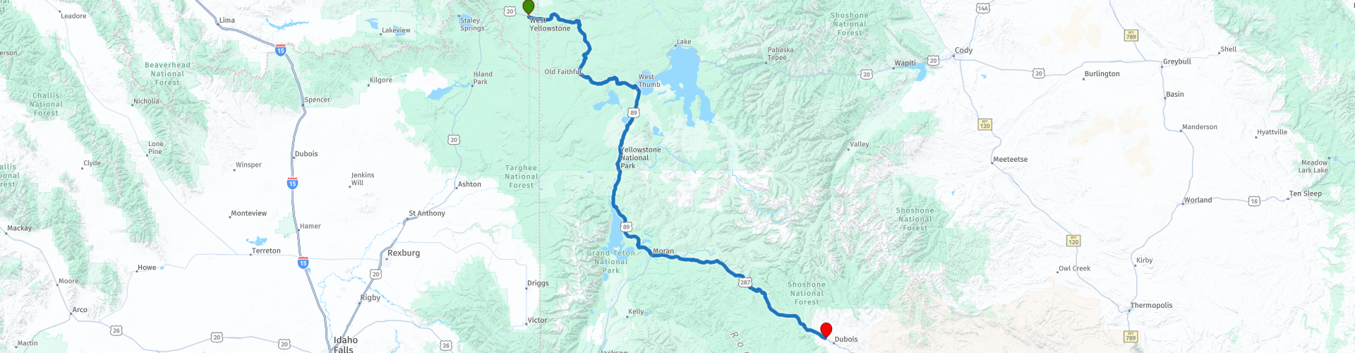
Starting point: Best Western Weston Inn.
End point: Super 8-Dubois.
The route has been made the same for TomTom, Garmin and MyRoute-app Navigation users.
Thanks to Richard & Lisa for the information!
 Share this route


Animation

Verdict


Duration
3h 30m

Mode of travel
Car or motorcycle

Distance
243.03 km

Countries

 RouteXpert Review
 We start the route again in Yellowstone National Park (NP), with its colored hot springs, sulfur fumes and geysers. Followed by the Teton National Forest, the Bridger-Teton is located in West Wyoming and offers more than 3.4 million acres of public land for your enjoyment in outdoor recreation. The Bridger-Teton National Forest consists of pristine river basins, an abundance of wildlife and immense wildlife lands. It consists largely of the Greater Yellowstone Ecosystem - the largest intact ecosystem. The park contains nearly 1.2 million acres of wilderness, more than 3,000 miles of roads and trails and thousands of miles of pristine rivers and streams, the Bridger-Teton offers something for everyone.
Then it goes through the Shoshone National Forrest. The Shoshone National Forest offers beautiful scenery and endless recreational opportunities! The Shoshone National Forest was reserved in 1891 as part of the Yellowstone Timberland Reserve, making the Shoshone the first national forest in the United States. It consists of approximately 2.4 million hectares of varied terrain, ranging from sagebrush flats to rugged mountains. The higher mountains are covered with snow most of the year. Immense areas of exposed rock are interspersed with meadows and forests. With Yellowstone National Park on the western border, the Shoshone covers the area from the Montana State Line in the south to Lander, Wyoming, and includes parts of the Absaroka, Wind River and Beartooth Mountains.
In this 4-star route you will drive along beautiful good roads, a stop at the Oxbow Bend Overlook and the Senic Overview over the Lunch Tree Hill is a must.
History:
The city of Dubois was founded in 1914. In the same year, Wyoming Tie and Timber Company opened woodworking activities here and eventually became the largest source of railroad ties in the country. The "tie hack" operations ended in 1949, after which Louisiana Pacific operated a sawmill in the city until 1988.


 Links
Links  Usage
Usage Want to download this route?
You can download the route for free without MyRoute-app account. To do so, open the route and click 'save as'. Want to edit this route?
No problem, start by opening the route. Follow the tutorial and create your personal MyRoute-app account. After registration, your trial starts automatically.  Disclaimer
Use of this GPS route is at your own expense and risk. The route has been carefully composed and checked by a MyRoute-app accredited RouteXpert for use on TomTom, Garmin and MyRoute-app Navigation.
Changes may nevertheless have occurred due to changed circumstances, road diversions or seasonal closures. We therefore recommend checking each route before use.
Preferably use the route track in your navigation system. More information about the use of MyRoute-app can be found on the website under 'Community' or 'Academy'.