Day 4 Roundtrip Great Smoky Mountains The Tail of the Dragon north to south and Cherohala Skyway

This route was brought to you by:
RouteXpert René Plücken (MRA Master)
Last edit: 20-08-2025
 Route Summary
 America is the perfect country to explore by motorcycle. Many tour companies offer organized trips, but there's also the charm of mapping out your own routes and riding independently. There are good motorcycle rental companies throughout the country, and the motorcycles are often the latest models and well-maintained.
We'll be driving along the beautiful roads in Nashville and North Carolina, and this area is characterized by its beautiful, idyllic landscape, with two-lane roads winding through the countryside. You can visit charming towns, villages, and attractions. Be careful, though, as the roads are sometimes of very poor quality and are barely lit, if at all, after dark.
This day is worth 5***** stars. Riding a motorcycle in the Great Smoky Mountains is a true pleasure. The roads and panoramas are stunning, and there are plenty of other sights and activities along the way to stop for.
 Share this route


Animation

Verdict


Duration
8h 49m

Mode of travel
Car or motorcycle

Distance
313.98 km

Countries

 RouteXpert Review
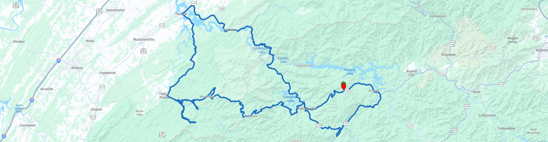
 This is a day with many beautiful winding roads, including the world-famous Tail of the Dragon (U129), an 11-mile (17.7-kilometer) road with 318 bends! We rode it south to north on day 3 and are riding it north to south today.
We also drove the Cherohala Skyway in the opposite direction as on day 2 and even though they are the same roads, driving them in the other direction is still a new and amazing experience.
After about 15 miles, you'll arrive at the Nantahala Outdoor Center and River's End Restaurant in Bryson City. Here, you can participate in outdoor activities (for those who enjoy them), such as mountain biking, rafting, canoeing, ziplining, or hiking the Apalachian Trail. There are also lodges, some shops, and a restaurant. It's located on the Nantahala River.
From Bryson City, we continue through the Nantahal Forest to Topton. A beautiful two-lane road through the forests and mountains of North Carolina. At Topton, we turn right and continue on Highway 129, a beautiful, winding mountain road to Robbinsville.
In Robbinsville, we stop at Lynn's Place, a favorite spot for bikers. Lynn's Place is a neighborhood soul food restaurant serving homemade American fare. They have a great salad bar with fresh-cut vegetables, seasonal fruit, steaks, burgers, delicious homemade desserts, and much more! Everything is cooked to order to ensure the highest quality. Experience a warm atmosphere with delicious food, Southern culture, and hospitality where family and friends can sit back, relax, and feel at home.
After a short or slightly longer break, we continue west to drive the Cherohala Skyway. This road is one of America's most famous scenic skyways, crossing the Cherokee and Nantahala National Forests, hence the name "Cherohala." The Skyway is becoming increasingly well-known in motorsport and sports car circles for its long, captivating curves, beautiful views, and cool summer breezes. This enthusiast's dream connects Robbinsville, North Carolina, with Tellico Plains, Tennessee.
After enjoying the series of twists and turns for 65 kilometers, we turn left onto River Road (note: OSM wants to turn right here!). We drive along the banks of the Tellico River to Bald River Falls, a 90-meter waterfall and one of the most spectacular in the area. Definitely worth planning a stop.
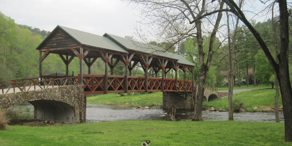
We continue the ride along the narrow and winding River Road and Bald River Road through the Tennessee woods to Tellico Plains, where you'll find the Cherohala Harley-Davidson Dealer, a grill restaurant, Iron Works Grill, and the beautiful old Telliquah Covered Bridge.
An ideal spot to stop and stretch your legs. This is also almost the end of the beautiful Cherohala Skyway, which ends just before Tellico Plains. Here we turn right and take TN-360 towards Vonore. In Vonore, we can stop for a cup of coffee at Hardee's and, if necessary, for gas.
We'll take a short drive on the highway to cross the Tellico River and then turn right onto TN72 to continue to the Tail of the Dragon, but first we'll stop at the Smoky Mountain Harley Dealership to pick up a T-shirt or other souvenir from The Dragon, in case you haven't already done so on Day 2.
We continue our journey to "The North Entrance" of the world-famous Tail of the Dragon, an 11-mile (17.7-kilometer) road with 318 curves! This road is a treat for motorcyclists. Be aware, however, that it can be busy with cars and other motorcyclists, so watch out for oncoming traffic. Overtaking is prohibited, and you're not allowed to ride on the opposite side of the road. Checks are frequent, and fines are hefty. More information about this fantastic road can be found in the link at the bottom of this review.
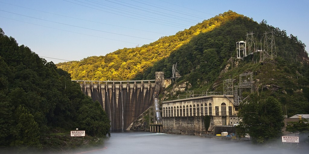
Along the Tail, be sure to stop at Calderwood Lake Lookout, where you'll have a magnificent view of Calderwood Lake and the dam of the same name in the distance. At the end of the "Tail of the Dragon," you can stop by the souvenir shop, restaurant, a beautiful large dragon statue, and, not to forget, "The Tree of Shame," which is hung with motorcycle parts from riders who underestimated this road.
The last 50 kilometers to the resort run along the Cheoah River and Lake Santeetlah. You'll ride past the Cheoah Dam, where you'll have a beautiful view. Via Robbinsville, we'll return to the Iron Horse Motorcycle Lodge and Resort, where we'll share our experiences with other bikers over drinks and a delicious meal in the evening.
 Links
Links  Usage
Usage Want to download this route?
You can download the route for free without MyRoute-app account. To do so, open the route and click 'save as'. Want to edit this route?
No problem, start by opening the route. Follow the tutorial and create your personal MyRoute-app account. After registration, your trial starts automatically.  Disclaimer
Use of this GPS route is at your own expense and risk. The route has been carefully composed and checked by a MyRoute-app accredited RouteXpert for use on TomTom, Garmin and MyRoute-app Navigation.
Changes may nevertheless have occurred due to changed circumstances, road diversions or seasonal closures. We therefore recommend checking each route before use.
Preferably use the route track in your navigation system. More information about the use of MyRoute-app can be found on the website under 'Community' or 'Academy'.