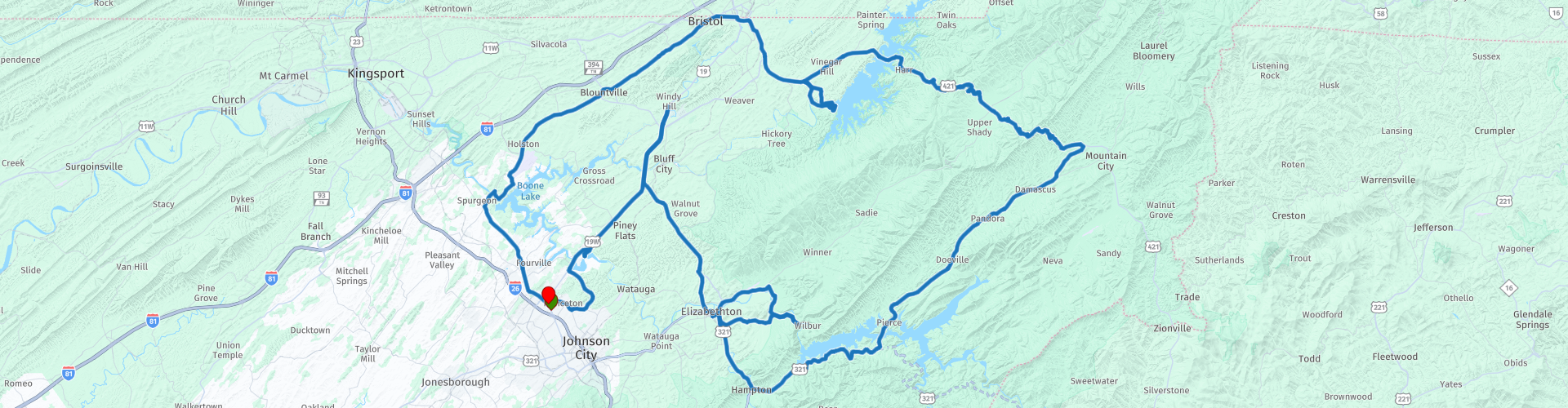
Johnson City Roundtrip The Southern Dozen Ride 07 The Long Dam Ride

This route was brought to you by:
RouteXpert René Plücken (MRA Master)
Last edit: 20-08-2025
 Route Summary
 Dit is “The Long Dam Ride”, deel 7 van de Southern Dozen, het is een spannende rit over de dammen langs meren, rivieren en nog veel meer interessante dingen.
Ik beoordeel deze rit met 5 sterren vanwege de bochtige wegen, het mooie landschap en interessante plekken om te bezoeken.
 Share this route


Animation

Verdict


Duration
8h 35m

Mode of travel
Car or motorcycle

Distance
225.23 km

Countries

 RouteXpert Review
 Dit is “The Long Dam Ride”, deel 7 van de Southern Dozen. Deze tour voert je door ruige kloven en langs rotswanden, bergbeekjes, rustige meren, unieke locaties, spectaculaire formaties en kilometerslange achtbaan dips en landelijke charme.
We bezoeken een paar dammen met spectaculaire uitzichten, steken een aantal prachtige bruggen over en rijden langs veel schilderachtige wegen; een van hen is de "the Snake", waarvan wordt gezegd dat hij "489 bochten, 3 bergen, 1 vallei ingepakt in 33 mijl!" heeft, dus dit is een spannende rit.
De eerste stop is bij Boone Dam, vernoemd naar pionier Daniel Boone (1734-1820), die in de jaren 1760 actief was in dit gebied. De Boone Dam is een waterkrachtcentrale en hoogwaterbestrijdingsdam op de South Fork Holston River op de grens tussen Sullivan County en Washington County in de Amerikaanse staat Tennessee. Het is een van de drie dammen aan de South Fork Holston die eigendom zijn van en worden geëxploiteerd door de Tennessee Valley Authority, die de dam in het begin van de jaren vijftig bouwde als onderdeel van grotere inspanningen om overstromingen in het stroomgebied van de Tennessee River te beheersen. De dam stuwt het 4500 acre (1800 ha) grote Boone Lake op, en het stroomafwaarts deel ervan maakt deel uit van het Fort Patrick Henry Lake. De dam en de bijbehorende infrastructuur zijn in 2017 opgenomen in het Nationaal Register van Historische Plaatsen.
We rijden door naar Bristol waar we kort stoppen bij de Bristol Motor Speedway, een ovaal Nascar autoracecircuit, voorheen bekend onder de namen Bristol International Raceway en Bristol Raceway. Het werd geopend in 1961. Maak wat foto's van dit beroemde Nascar-circuit en koop een souvenir in de cadeauwinkel. Als je geluk hebt is er een race gepland en kun je deze bijwonen.
De volgende stop is bij de South Holston Dam, een waterkracht- en waterkeringsdam aan de South Fork Holston River in Sullivan County, in de Amerikaanse staat Tennessee. Het is de bovenste van drie dammen aan de South Fork Holston die eigendom zijn van en worden beheerd door de Tennessee Valley Authority, die de dam in de jaren veertig bouwde als onderdeel van de inspanningen om overstromingen in het stroomgebied van de Tennessee River te beheersen. Op 21 oktober 1950 werd de klep gesloten en begon het water zich op te hopen, waardoor het South Holston Reservoir ontstond. De werkzaamheden aan de dam begonnen in december 1941, maar in november 1942 verzocht de War Production Board om de werkzaamheden op te schorten vanwege een tekort aan essentiële materialen. De werkzaamheden werden pas op 1 juli 1947 hervat. De dam vormt nu het South Holston Lake van 7550 acre (3060 ha), dat zich in noordoostelijke richting uitstrekt over de staatsgrens tussen Tennessee en Virginia.
In Holston Valley beginnen we met de rit over "the Snake" een prachtige, schilderachtige en opwindende rit door de bergen van Tennessee en Shady Valley naar Mountain City. We stoppen voor de lunch in Shady Valley bij de Country Store; een Biker-winkel en geweldige deli met souvenirs beschikbaar.
We vervolgen onze rit door de Cherokee National Mountains via Damascus en Butler langs het Watauga meer naar de Wilbur Dam, een waterkrachtcentrale aan de Watauga-rivier in Carter County. Het is een van de twee dammen op de rivier die eigendom is van en beheerd wordt door de Tennessee Valley Authority.
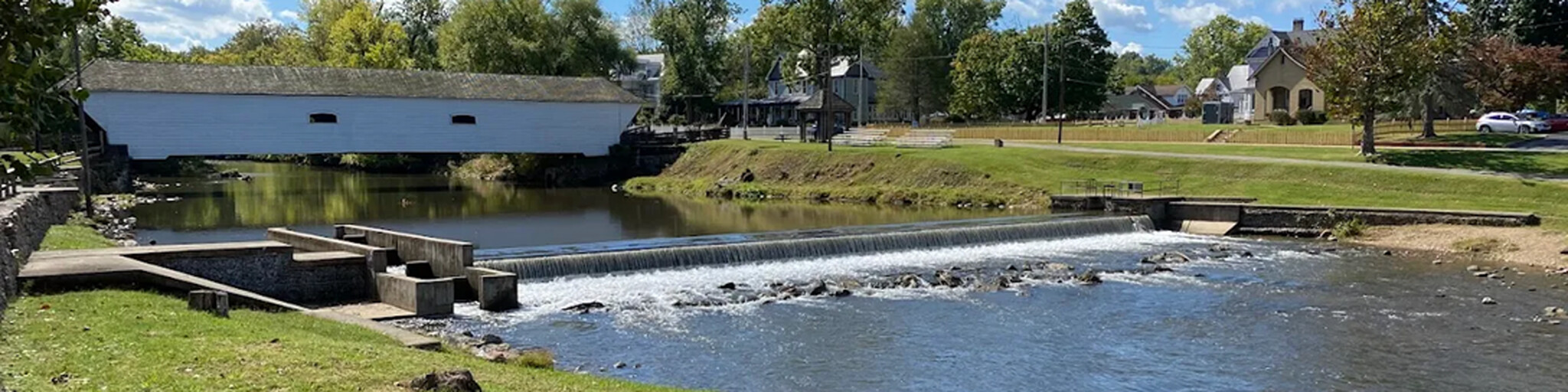
De rit gaat verder naar het noorden via Elizabethon, waar je kunt stoppen om een foto te maken van de historische Elizabethton Covered Bridge, een 40 meter lange overdekte brug over de Doe River in Elizabethton, de hoofdplaats van Carter County, Tennessee. De Elizabethton Covered Bridge werd gebouwd in 1882 en verbindt 3rd Street met Hattie Avenue. In Elizabethon kun je een korte pauze inplannen om iets te drinken.
Op de terugweg naar Johnson City kun je het Rocky Mountain Living Museum bezoeken, het ligt aan de voet van het prachtige Appalachen en biedt rondleidingen langs de verschillende locaties waar ze de levende geschiedenis gebruiken om het publiek meer inzicht te geven in het dagelijks leven en waarden van de vroege kolonisten in ons gebied.


 Links
Links  Usage
Usage Want to download this route?
You can download the route for free without MyRoute-app account. To do so, open the route and click 'save as'. Want to edit this route?
No problem, start by opening the route. Follow the tutorial and create your personal MyRoute-app account. After registration, your trial starts automatically.  Disclaimer
Use of this GPS route is at your own expense and risk. The route has been carefully composed and checked by a MyRoute-app accredited RouteXpert for use on TomTom, Garmin and MyRoute-app Navigation.
Changes may nevertheless have occurred due to changed circumstances, road diversions or seasonal closures. We therefore recommend checking each route before use.
Preferably use the route track in your navigation system. More information about the use of MyRoute-app can be found on the website under 'Community' or 'Academy'.

Tennessee
About this region
Tennessee, officially the State of Tennessee, is a state in the Southeastern region of the United States. Tennessee is the 36th largest by area and the 16th most populous of the 50 states. It is bordered by Kentucky to the north, Virginia to the northeast, North Carolina to the east, Georgia, Alabama, and Mississippi to the south, Arkansas to the southwest, and Missouri to the northwest. Tennessee is geographically, culturally, and legally divided into three Grand Divisions of East, Middle, and West Tennessee. Nashville is the state's capital and largest city, and anchors its largest metropolitan area. Tennessee's population as of the 2020 United States census is approximately 6.9 million.Tennessee is rooted in the Watauga Association, a 1772 frontier pact generally regarded as the first constitutional government west of the Appalachian Mountains. Its name is derived from "Tanasi", a Cherokee town in the eastern part of the state that existed before the first European American settlement. Tennessee was initially part of North Carolina, and later the Southwest Territory, before its admission to the Union as the 16th state on June 1, 1796. It earned the nickname "The Volunteer State" early in its history due to a strong tradition of military service. A slave state until the American Civil War, Tennessee was politically divided, with its western and middle parts supporting the Confederacy and the eastern region harboring pro-Union sentiment. As a result, Tennessee was the last state to secede and the first readmitted to the Union after the war.During the 20th century, Tennessee transitioned from a predominantly agrarian society to a more diversified economy. This was aided in part by massive federal investment in the Tennessee Valley Authority (TVA) and the city of Oak Ridge, which was established during World War II to house the Manhattan Project's uranium enrichment facilities for the construction of the world's first atomic bombs. These were dropped on Imperial Japan at the end of the war. After the war, the Oak Ridge National Laboratory became a key center of scientific research. In 2016, the element tennessine was named for the state, largely in recognition of the roles played by Oak Ridge, Vanderbilt University, and the University of Tennessee in its discovery. Tennessee has also played a major role in the development of many forms of popular music, including country, blues, rock and roll, soul, and gospel.
Tennessee has diverse terrain and landforms, and from east to west, contains a mix of cultural features characteristic of Appalachia, the Upland South, and the Deep South. The Blue Ridge Mountains along the eastern border reach some of the highest elevations in eastern North America, and the Cumberland Plateau contains many scenic valleys and waterfalls. The central part of the state is marked by cavernous bedrock and irregular rolling hills, and level, fertile plains define West Tennessee. The state is twice bisected by the Tennessee River, and the Mississippi River forms its western border. Its economy is dominated by the health care, music, finance, automotive, chemical, electronics, and tourism sectors, and cattle, soybeans, corn, poultry, and cotton are its primary agricultural products. The Great Smoky Mountains National Park, the nation's most visited national park, is in eastern Tennessee.
Read more on Wikipedia
Tennessee has diverse terrain and landforms, and from east to west, contains a mix of cultural features characteristic of Appalachia, the Upland South, and the Deep South. The Blue Ridge Mountains along the eastern border reach some of the highest elevations in eastern North America, and the Cumberland Plateau contains many scenic valleys and waterfalls. The central part of the state is marked by cavernous bedrock and irregular rolling hills, and level, fertile plains define West Tennessee. The state is twice bisected by the Tennessee River, and the Mississippi River forms its western border. Its economy is dominated by the health care, music, finance, automotive, chemical, electronics, and tourism sectors, and cattle, soybeans, corn, poultry, and cotton are its primary agricultural products. The Great Smoky Mountains National Park, the nation's most visited national park, is in eastern Tennessee.
View region
 Statistics
  40
40Amount of RX reviews (Tennessee)
 32983
32983Amount of visitors (Tennessee)
 1233
1233Amount of downloads (Tennessee)
 Route Collections in this region
 The Original Southern Dozen Motorcycle Rides in Tennessee Virginia and North Carolina
The Southern Dozen; hit the throttle and hold on tight!
There’s no better place to leave the daily grind in the dust than roaring around the curves of the Southern Dozen! Surrounded by some of the most breathtaking natural beauty in the country, you’ll find the freedom of exhilaration as you wind through the foothills and mountains of Northeast Tennessee, Southwest Virginia, and Western North Carolina.
Whether you’re looking for heart-pumping curves, breathtaking scenery, historic landmarks, local gems, or nearby attractions, the Southern Dozen has rides worthy of even the most seasoned road warrior. Explore the Original Southern Dozen and see all that Johnson City and the surrounding region have to offer.
Johnson City is a regional gem where big-city amenities meet small-town Southern charm. Here you’ll have access to everything you could want or need and more! Perfect for the casual rider and those who “live to ride,” Johnson City hosts numerous bike rallies each year. So plan your trip and book one of the many biker-friendly accommodations.
View Route Collection
The 10 most downloaded routes in the USA from RouteXpert Hans van de Ven
Hello and welcome to this collection of the Top 10 MyRoute app downloaded routes in USA.
There will be a great new event to be announced soon, where all these routes can be driven.
Download them all now and place them in a new "Top 10" folder, so that you always have them at hand.
If you are going to drive one of these routes in the meantime, track them with the MRA Mobile App or with MRA Navigation. Take some photos (moments) along the way as these will come in handy.
Create a travelogue of your Top 10 driven routes and add the recorded track to it.
There will also be some great prizes on offer, so keep an eye on the MRA-RouteXperts page and your mail.
The 10 routes are:
1. D13 Estes Park Denver
2. D03 Chadron Custer
3. D01 Pigeon Forge round trip through the Smokey Mountains
4. D08 Kalispell Sandpoint
5. D10 Colville Wenatchee
6. D09 Sandpoint Colville
7. D04 Custer Wall
8. D11 Wenatchee Seattle
9. D08 Cody Yellowstone NP
10.R13 San Francisco Monterey
View Route Collection