Day 4 Roundtrip Great Smoky Mountains The Tail of the Dragon north to south and Cherohala Skyway

This route was brought to you by:
RouteXpert René Plücken (MRA Master)
Last edit: 20-08-2025
 Route Summary
 America is the perfect country to explore by motorcycle. Many tour companies offer organized trips, but there's also the charm of mapping out your own routes and riding independently. There are good motorcycle rental companies throughout the country, and the motorcycles are often the latest models and well-maintained.
We'll be driving along the beautiful roads in Nashville and North Carolina, and this area is characterized by its beautiful, idyllic landscape, with two-lane roads winding through the countryside. You can visit charming towns, villages, and attractions. Be careful, though, as the roads are sometimes of very poor quality and are barely lit, if at all, after dark.
This day is worth 5***** stars. Riding a motorcycle in the Great Smoky Mountains is a true pleasure. The roads and panoramas are stunning, and there are plenty of other sights and activities along the way to stop for.
 Share this route


Animation

Verdict


Duration
8h 49m

Mode of travel
Car or motorcycle

Distance
313.98 km

Countries

 RouteXpert Review
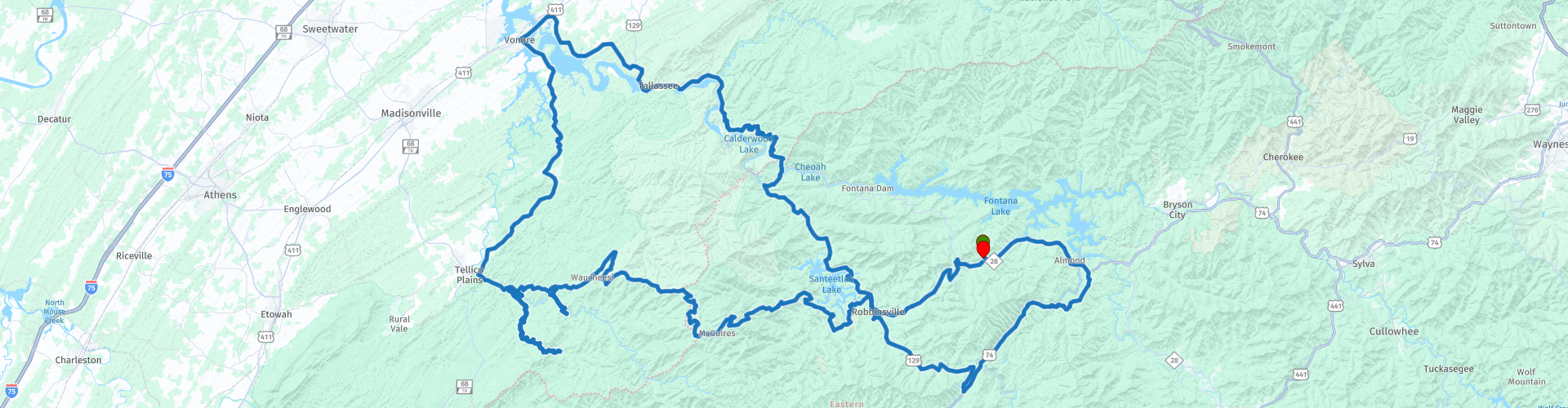
 This is a day with many beautiful winding roads, including the world-famous Tail of the Dragon (U129), an 11-mile (17.7-kilometer) road with 318 bends! We rode it south to north on day 3 and are riding it north to south today.
We also drove the Cherohala Skyway in the opposite direction as on day 2 and even though they are the same roads, driving them in the other direction is still a new and amazing experience.
After about 15 miles, you'll arrive at the Nantahala Outdoor Center and River's End Restaurant in Bryson City. Here, you can participate in outdoor activities (for those who enjoy them), such as mountain biking, rafting, canoeing, ziplining, or hiking the Apalachian Trail. There are also lodges, some shops, and a restaurant. It's located on the Nantahala River.
From Bryson City, we continue through the Nantahal Forest to Topton. A beautiful two-lane road through the forests and mountains of North Carolina. At Topton, we turn right and continue on Highway 129, a beautiful, winding mountain road to Robbinsville.
In Robbinsville, we stop at Lynn's Place, a favorite spot for bikers. Lynn's Place is a neighborhood soul food restaurant serving homemade American fare. They have a great salad bar with fresh-cut vegetables, seasonal fruit, steaks, burgers, delicious homemade desserts, and much more! Everything is cooked to order to ensure the highest quality. Experience a warm atmosphere with delicious food, Southern culture, and hospitality where family and friends can sit back, relax, and feel at home.
After a short or slightly longer break, we continue west to drive the Cherohala Skyway. This road is one of America's most famous scenic skyways, crossing the Cherokee and Nantahala National Forests, hence the name "Cherohala." The Skyway is becoming increasingly well-known in motorsport and sports car circles for its long, captivating curves, beautiful views, and cool summer breezes. This enthusiast's dream connects Robbinsville, North Carolina, with Tellico Plains, Tennessee.
After enjoying the series of twists and turns for 65 kilometers, we turn left onto River Road (note: OSM wants to turn right here!). We drive along the banks of the Tellico River to Bald River Falls, a 90-meter waterfall and one of the most spectacular in the area. Definitely worth planning a stop.
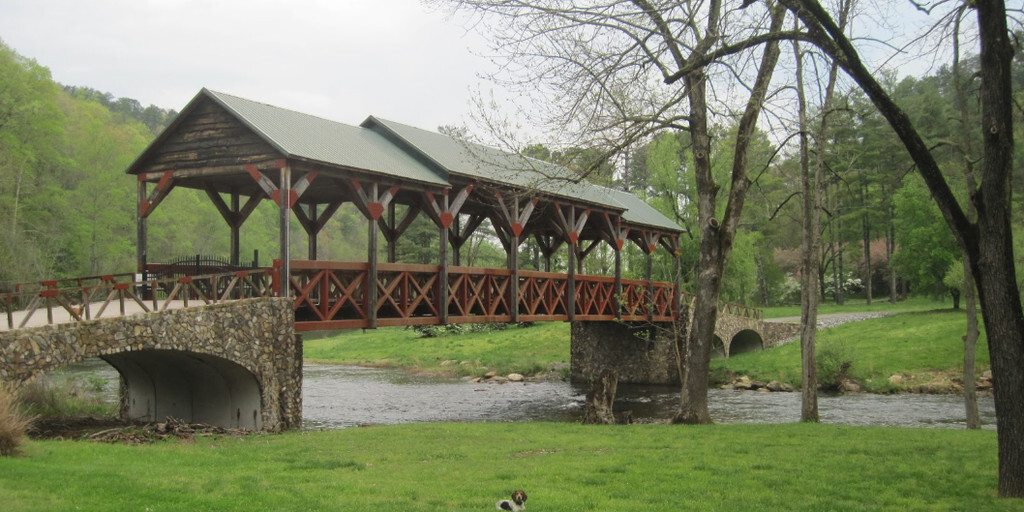
We continue the ride along the narrow and winding River Road and Bald River Road through the Tennessee woods to Tellico Plains, where you'll find the Cherohala Harley-Davidson Dealer, a grill restaurant, Iron Works Grill, and the beautiful old Telliquah Covered Bridge.
An ideal spot to stop and stretch your legs. This is also almost the end of the beautiful Cherohala Skyway, which ends just before Tellico Plains. Here we turn right and take TN-360 towards Vonore. In Vonore, we can stop for a cup of coffee at Hardee's and, if necessary, for gas.
We'll take a short drive on the highway to cross the Tellico River and then turn right onto TN72 to continue to the Tail of the Dragon, but first we'll stop at the Smoky Mountain Harley Dealership to pick up a T-shirt or other souvenir from The Dragon, in case you haven't already done so on Day 2.
We continue our journey to "The North Entrance" of the world-famous Tail of the Dragon, an 11-mile (17.7-kilometer) road with 318 curves! This road is a treat for motorcyclists. Be aware, however, that it can be busy with cars and other motorcyclists, so watch out for oncoming traffic. Overtaking is prohibited, and you're not allowed to ride on the opposite side of the road. Checks are frequent, and fines are hefty. More information about this fantastic road can be found in the link at the bottom of this review.
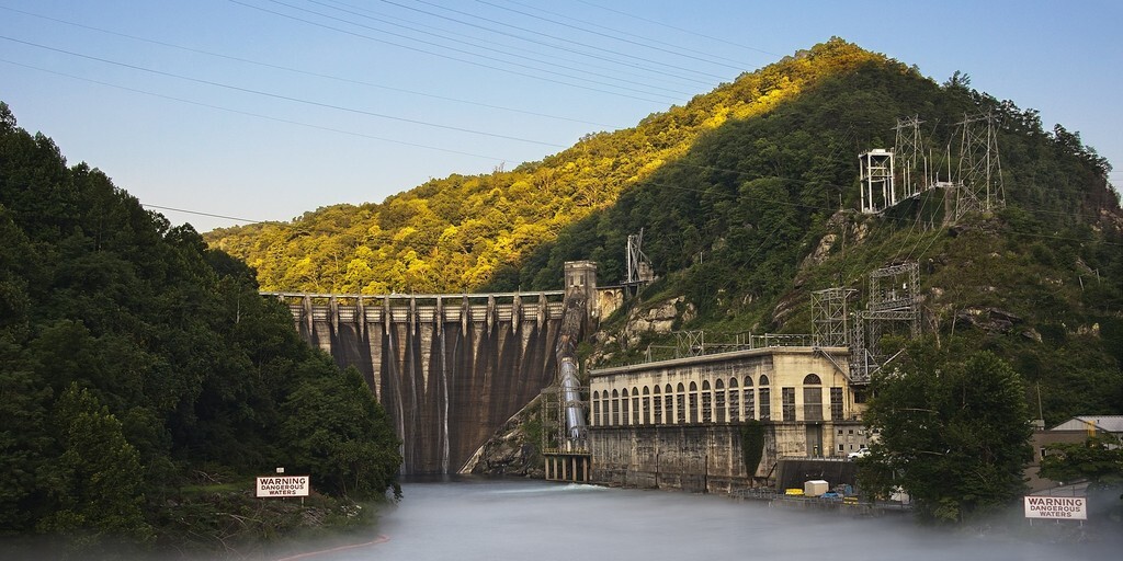
Along the Tail, be sure to stop at Calderwood Lake Lookout, where you'll have a magnificent view of Calderwood Lake and the dam of the same name in the distance. At the end of the "Tail of the Dragon," you can stop by the souvenir shop, restaurant, a beautiful large dragon statue, and, not to forget, "The Tree of Shame," which is hung with motorcycle parts from riders who underestimated this road.
The last 50 kilometers to the resort run along the Cheoah River and Lake Santeetlah. You'll ride past the Cheoah Dam, where you'll have a beautiful view. Via Robbinsville, we'll return to the Iron Horse Motorcycle Lodge and Resort, where we'll share our experiences with other bikers over drinks and a delicious meal in the evening.
 Links
Links  Usage
Usage Want to download this route?
You can download the route for free without MyRoute-app account. To do so, open the route and click 'save as'. Want to edit this route?
No problem, start by opening the route. Follow the tutorial and create your personal MyRoute-app account. After registration, your trial starts automatically.  Disclaimer
Use of this GPS route is at your own expense and risk. The route has been carefully composed and checked by a MyRoute-app accredited RouteXpert for use on TomTom, Garmin and MyRoute-app Navigation.
Changes may nevertheless have occurred due to changed circumstances, road diversions or seasonal closures. We therefore recommend checking each route before use.
Preferably use the route track in your navigation system. More information about the use of MyRoute-app can be found on the website under 'Community' or 'Academy'.

Tennessee
About this region
Tennessee, officially the State of Tennessee, is a state in the Southeastern region of the United States. Tennessee is the 36th largest by area and the 16th most populous of the 50 states. It is bordered by Kentucky to the north, Virginia to the northeast, North Carolina to the east, Georgia, Alabama, and Mississippi to the south, Arkansas to the southwest, and Missouri to the northwest. Tennessee is geographically, culturally, and legally divided into three Grand Divisions of East, Middle, and West Tennessee. Nashville is the state's capital and largest city, and anchors its largest metropolitan area. Tennessee's population as of the 2020 United States census is approximately 6.9 million.Tennessee is rooted in the Watauga Association, a 1772 frontier pact generally regarded as the first constitutional government west of the Appalachian Mountains. Its name is derived from "Tanasi", a Cherokee town in the eastern part of the state that existed before the first European American settlement. Tennessee was initially part of North Carolina, and later the Southwest Territory, before its admission to the Union as the 16th state on June 1, 1796. It earned the nickname "The Volunteer State" early in its history due to a strong tradition of military service. A slave state until the American Civil War, Tennessee was politically divided, with its western and middle parts supporting the Confederacy and the eastern region harboring pro-Union sentiment. As a result, Tennessee was the last state to secede and the first readmitted to the Union after the war.During the 20th century, Tennessee transitioned from a predominantly agrarian society to a more diversified economy. This was aided in part by massive federal investment in the Tennessee Valley Authority (TVA) and the city of Oak Ridge, which was established during World War II to house the Manhattan Project's uranium enrichment facilities for the construction of the world's first atomic bombs. These were dropped on Imperial Japan at the end of the war. After the war, the Oak Ridge National Laboratory became a key center of scientific research. In 2016, the element tennessine was named for the state, largely in recognition of the roles played by Oak Ridge, Vanderbilt University, and the University of Tennessee in its discovery. Tennessee has also played a major role in the development of many forms of popular music, including country, blues, rock and roll, soul, and gospel.
Tennessee has diverse terrain and landforms, and from east to west, contains a mix of cultural features characteristic of Appalachia, the Upland South, and the Deep South. The Blue Ridge Mountains along the eastern border reach some of the highest elevations in eastern North America, and the Cumberland Plateau contains many scenic valleys and waterfalls. The central part of the state is marked by cavernous bedrock and irregular rolling hills, and level, fertile plains define West Tennessee. The state is twice bisected by the Tennessee River, and the Mississippi River forms its western border. Its economy is dominated by the health care, music, finance, automotive, chemical, electronics, and tourism sectors, and cattle, soybeans, corn, poultry, and cotton are its primary agricultural products. The Great Smoky Mountains National Park, the nation's most visited national park, is in eastern Tennessee.
Read more on Wikipedia
Tennessee has diverse terrain and landforms, and from east to west, contains a mix of cultural features characteristic of Appalachia, the Upland South, and the Deep South. The Blue Ridge Mountains along the eastern border reach some of the highest elevations in eastern North America, and the Cumberland Plateau contains many scenic valleys and waterfalls. The central part of the state is marked by cavernous bedrock and irregular rolling hills, and level, fertile plains define West Tennessee. The state is twice bisected by the Tennessee River, and the Mississippi River forms its western border. Its economy is dominated by the health care, music, finance, automotive, chemical, electronics, and tourism sectors, and cattle, soybeans, corn, poultry, and cotton are its primary agricultural products. The Great Smoky Mountains National Park, the nation's most visited national park, is in eastern Tennessee.
View region
 Statistics
  40
40Amount of RX reviews (Tennessee)
 32862
32862Amount of visitors (Tennessee)
 1233
1233Amount of downloads (Tennessee)
 Route Collections in this region
 The Original Southern Dozen Motorcycle Rides in Tennessee Virginia and North Carolina
The Southern Dozen; hit the throttle and hold on tight!
There’s no better place to leave the daily grind in the dust than roaring around the curves of the Southern Dozen! Surrounded by some of the most breathtaking natural beauty in the country, you’ll find the freedom of exhilaration as you wind through the foothills and mountains of Northeast Tennessee, Southwest Virginia, and Western North Carolina.
Whether you’re looking for heart-pumping curves, breathtaking scenery, historic landmarks, local gems, or nearby attractions, the Southern Dozen has rides worthy of even the most seasoned road warrior. Explore the Original Southern Dozen and see all that Johnson City and the surrounding region have to offer.
Johnson City is a regional gem where big-city amenities meet small-town Southern charm. Here you’ll have access to everything you could want or need and more! Perfect for the casual rider and those who “live to ride,” Johnson City hosts numerous bike rallies each year. So plan your trip and book one of the many biker-friendly accommodations.
View Route Collection
The 10 most downloaded routes in the USA from RouteXpert Hans van de Ven
Hello and welcome to this collection of the Top 10 MyRoute app downloaded routes in USA.
There will be a great new event to be announced soon, where all these routes can be driven.
Download them all now and place them in a new "Top 10" folder, so that you always have them at hand.
If you are going to drive one of these routes in the meantime, track them with the MRA Mobile App or with MRA Navigation. Take some photos (moments) along the way as these will come in handy.
Create a travelogue of your Top 10 driven routes and add the recorded track to it.
There will also be some great prizes on offer, so keep an eye on the MRA-RouteXperts page and your mail.
The 10 routes are:
1. D13 Estes Park Denver
2. D03 Chadron Custer
3. D01 Pigeon Forge round trip through the Smokey Mountains
4. D08 Kalispell Sandpoint
5. D10 Colville Wenatchee
6. D09 Sandpoint Colville
7. D04 Custer Wall
8. D11 Wenatchee Seattle
9. D08 Cody Yellowstone NP
10.R13 San Francisco Monterey
View Route Collection