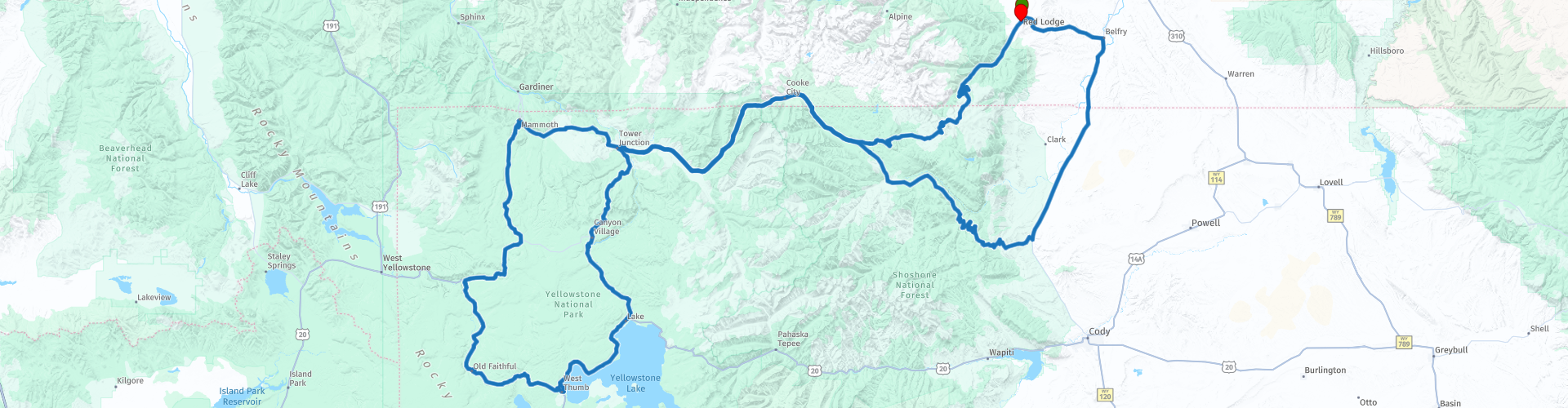
Red Lodge to Old Faithfull Two Day Round trip Beartooth Highway and Yellowstone Park

This route was brought to you by:
RouteXpert René Plücken (MRA Master)
Last edit: 20-08-2025
 Route Summary
 Along the way you can visit several beautiful sights in Yellowstone Park, there are beautiful lakes, waterfalls, and especially many geysers and mud pits.
Please note that the Beartooth Highway is not open year-round, so plan your trip in advance. The Beartooth Highway is best driven between late May and mid-October, when the road is generally open and accessible. However, due to the high elevation and unpredictable weather, the road can be temporarily closed even during these months.
I rate this ride 5 stars because of the beautiful winding roads and scenery
 Share this route


Animation

Verdict


Duration
33h 36m

Mode of travel
Car or motorcycle

Distance
542.80 km

Countries

 RouteXpert Review
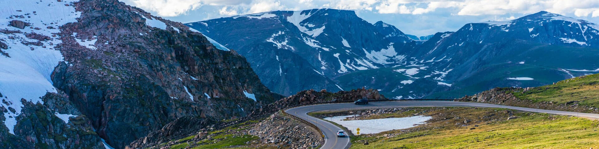
 The route features a series of steep zigzags and winding roads, following the Montana/Wyoming border to the 35,000-foot (10,847 m) Beartooth Pass, and requires an experienced rider. The estimated elevation gain is from 5,200 ft (1,600 m) to 8,000 ft (2,400 m) in 12 miles (19 km) of some of the most daring scenery.
Driving east-west, you'll reach the highest portions of the Beartooth Highway to a broad plateau at the top of the pass, then descend to the junction with Wyoming Highway 296 (Chief Joseph Scenic Byway) at Cooke City, the northeastern gateway to Yellowstone National Park.
Along the way you will pass numerous lakes typical of the Absaroka-Beartooth Wilderness Area that runs along much of the route. Take your time to enjoy the drive and stop to look around or park to admire the scenery and take photos. There are a number of campgrounds and picnic areas near the lakes that will make for great photo opportunities.
In Silver Gate (formerly part of Cooke City) you can plan lunch and fuel up, before we enter Yellowstone Park on the beautiful scenic road, along the route there are several parking areas where you can stop to enjoy the surroundings and take pictures, some of which are included in this review.
- Mammoth Hot Springs features a 3.5-mile trail with hiking trails past springs and a waterfall.
- Terrace Springs with a short walking trail on boardwalks along some beautiful springs.
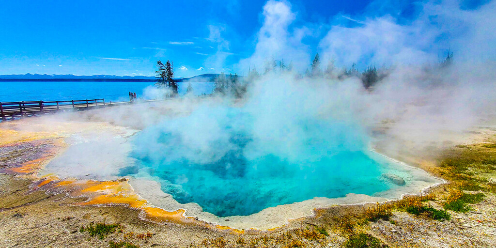
- Fountain Paint Pot Trail, where you will see several hydrothermal features that are expressions of the still active Yellowstone volcano. Within this geologic system, every type of thermal feature is represented. They can be grouped into two general categories - those with abundant water (hot springs and geysers) and those with limited water (mud pools and fumaroles). Despite their structural similarities, no two features are exactly alike.
- Bisquit Basin Trail is a beautiful scenic trail that passes through a number of geothermal features on a developed boardwalk. Closed due to an eruption on July 23, 2024.
We will be staying at the Old Faithful Inn, one of the most popular accommodations in Yellowstone National Park, so book in advance and early. This lodge is ideally situated overlooking the world-famous Old Faithful Geyser and offers many highlights and benefits you won’t find anywhere else. The inn has over 300 rooms available, including newly renovated suites and premium rooms that combine old-world and modern features that are a testament to Yellowstone’s history.
There are a number of waypoints included in this route where you can stop to take a picture of the beautiful scenery and the waterfalls;
- Kepler Cascades Waterfall, which flows rapidly through a rocky gorge just south of Old Faithful Village, draws large crowds of visitors to a region dominated by geysers.
- West Thumb Geyser Basin and Yellowstone Lake, the largest geyser basin on the shores of Yellowstone Lake (including Potts Basin to the north).
- The Fishing Bridge Visitor Center and Museum, a great place to stop. In this old wooden building you will discover the wide variety of wildlife that lives in and around the largest lake over 7,000 feet in North America. There are several animal displays in the visitor center including: grizzly bears, bald eagle, trumpeter swan and many more
- Le Hardy's Rapids is a section of the Yellowstone River where the riverbed drops slightly, throwing the water against large rocks and creating turbulent white water.
- The Brink of Lower Falls and Lower Lookout Point are incredible places to enjoy the view of the mighty Lower Falls of the Yellowstone River in Yellowstone. Be careful, the road to the parking lot is unpaved.
- Tower Falls, A short trail leads to the viewing platform. Tower Falls is a waterfall on Tower Creek in northeastern Yellowstone National Park, Wyoming, USA. About 1,000 meters upstream from the creek's confluence with the Yellowstone River, the falls plunge 132 feet.
In Canyon Village you can stop for lunch and fuel.
Once you have completed the Yellowstone Grand Loop, drive back via the Beartooth Highway to Red Lodge. Enjoy the drive back and it gives you a different perspective on the beautiful landscape.

 Links
Links  Usage
Usage Want to download this route?
You can download the route for free without MyRoute-app account. To do so, open the route and click 'save as'. Want to edit this route?
No problem, start by opening the route. Follow the tutorial and create your personal MyRoute-app account. After registration, your trial starts automatically.  Disclaimer
Use of this GPS route is at your own expense and risk. The route has been carefully composed and checked by a MyRoute-app accredited RouteXpert for use on TomTom, Garmin and MyRoute-app Navigation.
Changes may nevertheless have occurred due to changed circumstances, road diversions or seasonal closures. We therefore recommend checking each route before use.
Preferably use the route track in your navigation system. More information about the use of MyRoute-app can be found on the website under 'Community' or 'Academy'.

Wyoming
About this region
Wyoming is a state in the Mountain West subregion of the Western United States. The 10th largest state by area, it is also the least populous and least densely populated state in the contiguous United States. It is bordered by Montana to the north and northwest, South Dakota and Nebraska to the east, Idaho to the west, Utah to the southwest, and Colorado to the south. The state population was 576,851 at the 2020 United States census, making it the least populated U.S. state. The state capital and the most populous city is Cheyenne, which had an estimated population of 63,957 in 2018.Wyoming's western half is mostly covered by the ranges and rangelands of the Rocky Mountains, while the eastern half of the state is high-elevation prairie called the High Plains. It is drier and windier than the rest of the country, being split between semi-arid and continental climates with greater temperature extremes. Almost half of the land in Wyoming is owned by the federal government, leading the state to rank 6th by area and fifth by proportion of a state's land owned by the federal government. Federal lands include two national parks—Grand Teton and Yellowstone—two national recreation areas, two national monuments, several national forests, historic sites, fish hatcheries, and wildlife refuges.
Original inhabitants of the region include the Arapaho, Crow, Lakota, and Shoshone. Southwest Wyoming was claimed by the Spanish Empire and then as Mexican territory until it was ceded to the U.S. in 1848 at the end of the Mexican–American War. The region acquired the name "Wyoming" when a bill was introduced to Congress in 1865 to provide a temporary government for the territory of Wyoming. The name had been used earlier for the Wyoming Valley in Pennsylvania, and is derived from the Munsee word xwé:wamənk, meaning "at the big river flat".Wyoming's economy is driven by tourism and the extraction of minerals such as coal, natural gas, oil, and trona. Agricultural commodities include barley, hay, livestock, sugar beets, wheat, and wool. It was the first state to allow women the right to vote and become politicians, as well as the first state to elect a female governor. Due to this part of its history, its main nickname is "The Equality State" and its official state motto is "Equal Rights". It has been a politically conservative state since the 1950s, with the Republican presidential nominee carrying the state in every election since 1968. A notable exception is Teton County, which has achieved notability for being Wyoming's most Democratic county and the only county in the state to be won by a Democrat in every election since 2004.
Read more on Wikipedia
Original inhabitants of the region include the Arapaho, Crow, Lakota, and Shoshone. Southwest Wyoming was claimed by the Spanish Empire and then as Mexican territory until it was ceded to the U.S. in 1848 at the end of the Mexican–American War. The region acquired the name "Wyoming" when a bill was introduced to Congress in 1865 to provide a temporary government for the territory of Wyoming. The name had been used earlier for the Wyoming Valley in Pennsylvania, and is derived from the Munsee word xwé:wamənk, meaning "at the big river flat".Wyoming's economy is driven by tourism and the extraction of minerals such as coal, natural gas, oil, and trona. Agricultural commodities include barley, hay, livestock, sugar beets, wheat, and wool. It was the first state to allow women the right to vote and become politicians, as well as the first state to elect a female governor. Due to this part of its history, its main nickname is "The Equality State" and its official state motto is "Equal Rights". It has been a politically conservative state since the 1950s, with the Republican presidential nominee carrying the state in every election since 1968. A notable exception is Teton County, which has achieved notability for being Wyoming's most Democratic county and the only county in the state to be won by a Democrat in every election since 2004.
View region
 Statistics
  20
20Amount of RX reviews (Wyoming)
 20539
20539Amount of visitors (Wyoming)
 340
340Amount of downloads (Wyoming)
 Route Collections in this region
 Top car and motorcycle tour through the Midwest of the USA
By car or motorcycle through the Midwest of America is a journey that you do not just make, so it is not a 13-day drive and then back home. No, book a stay of several days in Denver, Cheyenne, Rapid City (In August the Sturgis Bike Ralley, stay there for a day or 4), Yellowstone National Park, Estes Park and again Denver to also visit several places of interest in these cities, so that this tour becomes an unforgettable tour that you can remember with pleasure.
Do not forget to arrange and pack the following items:
*This is only a summary and completely personal and may differ per person.
Take out travel insurance, +31 for numbers in GSM, (partially) take out gas, Health insurance coverage at destination?, Switch off electrical appliances, Lighting (time clock), Check passport validity, Antenna from radio/TV due to lightning, Residence address for those left behind, Remote control house alarm, Book Smart Parking.
Hand luggage:
Liquids in packaging of max. 100 ml, Liquids in hand luggage in transparent plastic bag.
For on the road:
Candy, Book, Earplugs, Country and road map(s), Directions, Maps in your navigation system
Money & Securities:
Bank card / giro card, Credit card (think pin code), Cash, Calculator for Internet banking, Medical insurance card, Travel insurance card.
Travel documents:
Passport, (International) Driver's License, Ticket(s), Reservation Tickets, Hotel Vouchers, Arrival/Departure Time, Check-in & Check-out Times, Valid Visa (ESTA), Travel Guide.
Clothing:
Underwear, Belt, Shirts/ T-shirts, Shorts, Long pants, Shoes, Socks, Swim trunks, Towel, Slippers.
Personal stuff:
Watch, House Keys, Wallet, Sunglasses.
Toiletries:
Deodorant, Shower gel / Soap, Comb / brush, Shaving equipment, Shampoo, Toothbrush, Toothpaste, Sanitary pads
Health & Medicine:
Own medicines, Insect repellent, Cold sore ointment, Ointment for insect bites, Sunscreen, Norit, Paracetamol, Suction cup for insect bites, First aid bag.
Miscellaneous:
Travel bag / waist bag, Leatherman (= checked luggage), Pen or pencil, Headlamp, Lighter, Tools & Electronics, Mobile phone & charger, Photo/video camera & charger, Memory card(s), World plug / adapter, Ipod & charger, Adapter cable Ipod, Headphones, iPad & charger, Navigation & charger/plug, Plug socket, Fuelpack battery.
Engine (accessories):
Helmet, Motorcycle clothing, Motorcycle boots, Chain lock / disc brake lock, Gloves, Bandana, Inner bags (plastic shopping bag), Insulation bag, Tension straps, Tie wraps, Rain suit, Rainaway.
Addresses:
Address list, Embassy telephone number, Telephone number to block (bank) card(s), Telephone number (airline tickets).
View Route Collection
The 10 most downloaded routes in the USA from RouteXpert Hans van de Ven
Hello and welcome to this collection of the Top 10 MyRoute app downloaded routes in USA.
There will be a great new event to be announced soon, where all these routes can be driven.
Download them all now and place them in a new "Top 10" folder, so that you always have them at hand.
If you are going to drive one of these routes in the meantime, track them with the MRA Mobile App or with MRA Navigation. Take some photos (moments) along the way as these will come in handy.
Create a travelogue of your Top 10 driven routes and add the recorded track to it.
There will also be some great prizes on offer, so keep an eye on the MRA-RouteXperts page and your mail.
The 10 routes are:
1. D13 Estes Park Denver
2. D03 Chadron Custer
3. D01 Pigeon Forge round trip through the Smokey Mountains
4. D08 Kalispell Sandpoint
5. D10 Colville Wenatchee
6. D09 Sandpoint Colville
7. D04 Custer Wall
8. D11 Wenatchee Seattle
9. D08 Cody Yellowstone NP
10.R13 San Francisco Monterey
View Route Collection