07A Uniondale R332 Baviaanskloof Jeffreys Bay Adventure

This route was brought to you by:
RouteXpert René Plücken (MRA Master)
Last edit: 15-12-2025
 Route Summary
 This route is part of a road trip in South Africa from Cape Town to Pretoria. You'll need at least 16 days to complete this complete road trip.
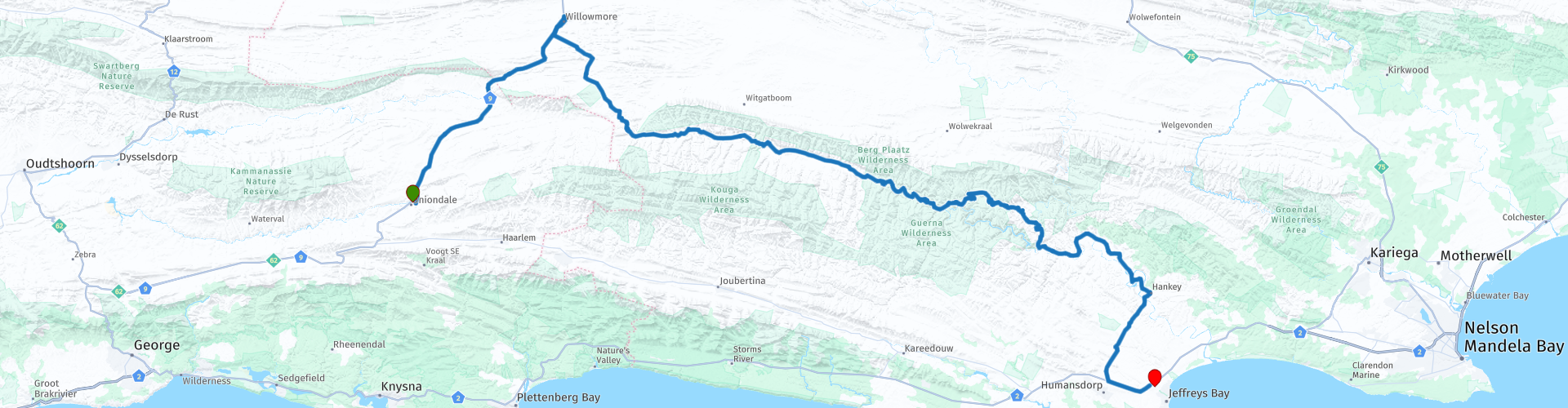
This is a beautiful drive from Uniondale to Jeffreys Bay. We'll be traveling along the R332, a largely unpaved road that runs through the Baviaanskloof Wilderness Area in the Eastern Cape, South Africa, and includes several spectacular mountain passes and gates, including Grasnek Pass, Holgat Pass, Langkop Pass, Combrink's Pass, and Nuwekloof Pass.
The Baviaanskloof Wilderness Area is a beautiful nature reserve with plenty to see and do. If you'd like to drive the route over a few days to see more of this stunning area, you can stay overnight at various campsites and guesthouses.
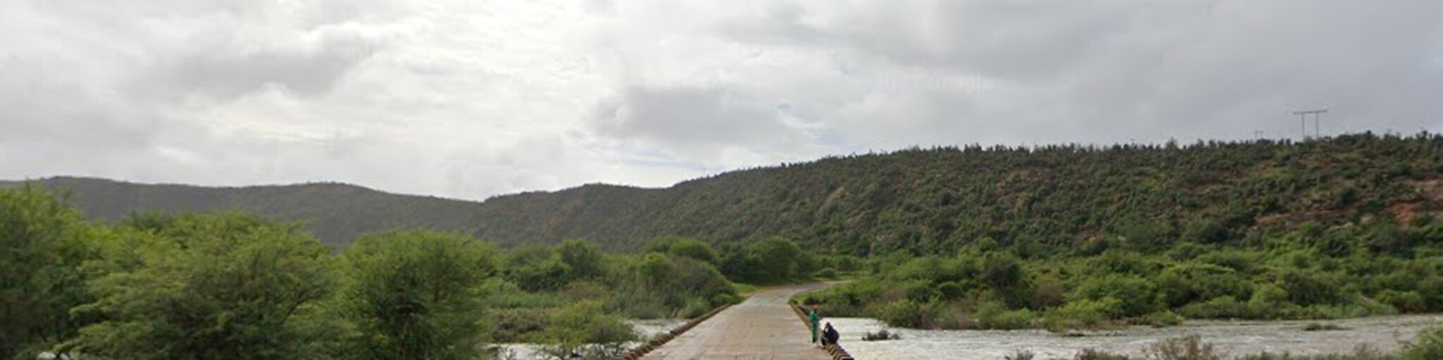
The road is known for its rugged, steep, and winding nature, including fordable rivers, and is often considered challenging. Therefore, a suitable motorcycle (all-road or off-road) or 4x4 vehicle is recommended for this trip. Some experience driving on this type of road is essential.
For those who prefer not to drive on unpaved roads, there's another route that only uses paved roads. The paved road route (07 Uniondale Humansdorp Jeffreys Bay) is included in the RouteXpert library; the link can be found in this review.
Enjoy this beautiful ride which I rate with 5 stars.
 Share this route


Animation

Verdict


Duration
8h 50m

Mode of travel
Car or motorcycle

Distance
309.60 km

Countries

 RouteXpert Review
 The R322 is largely a narrow gravel road through beautiful countryside, but you should drive slowly and carefully. The road was built between 1880 and 1890 by South Africa's most famous road builder, Thomas Bain. The road is 171 km long and runs east-west from Willowmore to Patensie. Make sure you have enough fuel and provisions for the trip. The road is entirely unpaved, and a suitable motorcycle, quad bike, or 4x4 is required. The road is often very steep and narrow, reaching an elevation of 1,157 m above sea level.
The route crosses the Baviaans River several times, and crossing it shouldn't be taken lightly. The water can be shallow, but be aware that the water level can change drastically with rainfall and can sometimes even wash away the road during the rainy season. So, be prepared and check the road conditions before you set off. For up-to-date information about roads in South Africa, it's best to check the website (see links in this review) of the local road safety organization. Points where you need to cross the river are marked with a point of interest (POI).
Count on at least 7-8 hours to complete the drive without stops. The area is quite remote, and there's no cell phone reception in Baviaanskloof. If you'd like to drive the route over several days and see more of this beautiful area, you can stay overnight at various campsites and guesthouses. There are several stops along the way for food, drinks, or rest.
The word Baviaanskloof, though derived from the Dutch "valley of the baboons," is associated with unspoiled nature, narrow gorges with flowing streams, steep mountain passes, vast plains of swaying grasslands, and views of pristine wilderness. Nature has taken its course over thousands of years to create what is now universally recognized as the Baviaanskloof World Heritage Site. Few other places in the world hold evidence of the footprint of human history spanning over a million years.
We drive the R332 from west to east through the narrow Baviaanskloof Valley. This road is bordered by two mountain ranges: the Baviaanskloof Mountains to the north and the Kouga Mountains to the south. The valley is lower than the Karoo to the north. Rainfall from the Karoo seeps through the mountains to the Baviaanskloof River. This makes the valley surprisingly lush and supports a greater diversity of plant species than might otherwise be expected.
We'll drive over spectacular mountain passes, including the Nuwekloof Pass, Studtis Poort, Grasnek Pass, Langkop Pass, Holgat Pass, and Combrink's Pass, offering stunning scenery and panoramic views.
Take the following into account:
- There is no mobile coverage in the Baviaanskloof.
There are no ATMs or banks in Baviaanskloof, and card payments are only accepted at selected locations.
- Ensure you have sufficient cash for accommodation, meals, entry to the Baviaanskloof Wilderness Reserve, etc.
There are no gas stations in Baviaanskloof. You can fill up at the Engen Garage in Willowmore; they're open 24/7.
If you choose to self-cater or camp in Baviaanskloof, stock up on provisions at Foodzone in Willowmore, open from 7:30 AM to 6:00 PM Monday to Friday and from 8:00 AM to 1:00 PM on Saturdays and Sundays.
The drive through the Baviaanskloof from Willowmore to Patensie takes approximately 7-8 hours.
- Make sure you bring tools for changing flat tires, and for cars, a spare tire as well.
Well-prepared, we embark on this challenging ride. The first pass is the Nuwekloof Pass, a highly challenging one, including several river crossings. The Nuwekloof Pass has a long history dating back to the early 18th century and is also known, in various forms, as the Nieuwekloof Pass, the Roodezand Pass, or the Tulbaghkloof Pass.
Visit the new Baviaanskloof Information and Visitor Centre in the Nuwekloof Pass. This centre has been upgraded with EU funding by the Department of Tourism and the Eastern Cape Parks and Tourism Agency. The centre includes a modern information centre, a conference room, an attractive range of platforms for informative and immersive virtual tours, a cafeteria, restrooms, and a covered terrace.
In the Nuwekloof Pass, you can stop at Vero's Restaurant to enjoy a drink or a roosterkoek, available with various fillings. Roosterkoek is a traditional South African bread often eaten at a BBQ (Braai).
Also visit the uniquely designed Baviaans Craft Shop, which sells handicrafts from the Baviaans region. With its green roof, the building itself is a work of art. The shop is part of the Baviaans Community Upliftment Project. Other items related to the Baviaanskloof, such as T-shirts, are also for sale.
The next pass, or gate, is the Studtis Gate. It's exceptionally scenic, with gentle gradients, as the road largely follows the river. You'll have views of towering mountains with nearly vertical cliffs and dense riverine vegetation. This beautiful and spectacular gate on the R332 stretches for 6.4 km and crosses the Baviaanskloof River nine times. Be careful when crossing the river; if you easily manage the first crossing, all eight other crossings shouldn't be a problem, as it's the same river with roughly the same depth and current. Studtis Gate often experiences deep water after rain, so be sure to check ahead.
You can enjoy a light lunch at BaviJAANS Padstal, a charming coffee shop in the valley. They offer breakfast, a light lunch, toasted bread, coffee, tea, and milkshakes, gifts and jam, and Wi-Fi vouchers.
Be sure to stop by "Babes se Winkel," one of two traditional businesses in the heart of the Westelijke Baviaanskloof. This shop takes you back to an era reminiscent of the 1950s. Babes himself sadly passed away in January 2020, and Gustav Nortje now runs the shop for the Baviaanskloof Hartland Community. The shop is well-stocked with fresh produce at reasonable prices. If you've forgotten something from home or want to buy something local, this is a good place to stock up. It also serves as the post office for Studtis and a cooperative for the local farmers and community.
After the Studtis Gate, you'll arrive at the West Gate of the Baviaanskloof Wilderness Area, which provides access to this beautiful nature reserve. The gate is open from 5:00 AM to 4:00 PM. Make sure you have enough cash on hand to pay the entrance fee. Cash only: R40 (€1.95/$2.25).
The next pass is the Grasnek Pass, one of the most scenic passes with many bends. The Grasnek Pass is probably the most beautiful in terms of scenic beauty. At 8.3 km, it is quite long and has no fewer than 83 bends, which equates to one bend every 100 meters. The pass is well-designed (especially considering its age) and offers a fairly moderate gradient, both uphill and downhill. The 3.7 km western climb rises from 247 m to 447 m above sea level, resulting in steep slopes. The view from the ridge and the summit area is indescribable.
The next pass is the smaller, but very steep Langkop Pass, located between the two major Baviaanskloof passes, Grasnek and Holgat. Due to the very steep gradients, the road is partially paved for better grip. The pass connects the Rooihoek campsite in the west with Doodsklip in the east and offers a wide variety of landscapes and some technical routes. It is precisely the paved surface of this road that has presented drivers with new challenges. The pass is short at 3.4 km and is full of sharp bends, steep climbs, and technical riding. On the other hand, it offers fantastic scenery and several river crossings before, during, and after the pass. The river crossing at Doodsklip can often be quite deep.
Then comes the 'Holgat Pass,' the fifth pass you have to cross; this is often confused with the Combrink Pass. The pass is essentially the climb to the last major mountain climb for travelers heading east, interrupted by a high plateau (where the Bergplaas campsites are located), followed by the Combrink Pass as a descent.
The final pass is Combrink's Pass, the highest in terms of elevation gain, with steep, exposed drops. Regardless of which direction you take the pass, it's a visual spectacle. This is the last pass you encounter before leaving the biosphere reserve and entering the Cambria Valley. The Cambria Valley resembles the Cambria Valley in Wales, hence its name. Citrus orchards adorn the slopes on either side of the river.
Over a distance of 5.5 km, the road descends 333 m via 73 bends, resulting in a moderate gradient, but with some steep sections. The road is single track and very narrow for most of its length. This pass is highly recommended for the stunning views along its entire length. However, for those with a fear of heights, the steep and completely unguarded slopes can be quite intimidating.
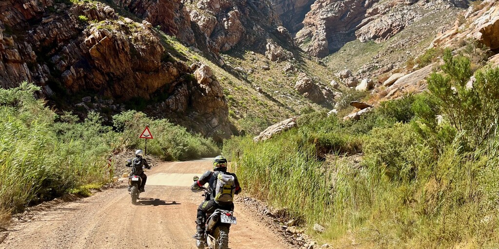
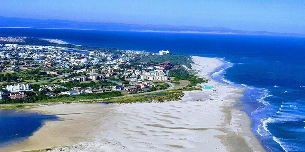
At the end of the R332 we arrive in Patensie, where we stop at the gas station to fill up the tanks for the final leg of the journey to our final destination, Jeffrey's Bay.
This is a fantastic holiday destination and a true surfer's paradise. Surfers from all over the world flock here to enjoy the sun, sea, golden beaches, and legendary waves. It's one of the world's best surfing locations and hosts the annual Billabong international surfing competition. But besides all the surfing events, you can stroll along Dolphin Beach or swim and sunbathe under the South African sun.
Between June and December, this is the place to see Southern Right Whales and Humpback Whales swimming towards warmer waters. Occasionally, orcas and Bryde's whales are spotted. Bottlenose and humpback dolphins are frequently seen here year-round. The wonderful climate, sea, dunes, bushveld, and forests create a rich bird life in and around Jeffrey's Bay, with 450 different species of feathered friends.
The village offers numerous restaurants, from takeaway to upscale, as well as coffee shops, shops, surf shops, and schools for diving, surfing, and sandboarding lessons. Enjoy your stay in Jeffrey's Bay.
 Links
Links  Usage
Usage Want to download this route?
You can download the route for free without MyRoute-app account. To do so, open the route and click 'save as'. Want to edit this route?
No problem, start by opening the route. Follow the tutorial and create your personal MyRoute-app account. After registration, your trial starts automatically.  Disclaimer
Use of this GPS route is at your own expense and risk. The route has been carefully composed and checked by a MyRoute-app accredited RouteXpert for use on TomTom, Garmin and MyRoute-app Navigation.
Changes may nevertheless have occurred due to changed circumstances, road diversions or seasonal closures. We therefore recommend checking each route before use.
Preferably use the route track in your navigation system. More information about the use of MyRoute-app can be found on the website under 'Community' or 'Academy'.

South Africa
About this region
South Africa, officially the Republic of South Africa (RSA), is the southernmost country in Africa. Its nine provinces are bounded to the south by 2,798 kilometres (1,739 miles) of coastline that stretches along the South Atlantic and Indian Ocean; to the north by the neighbouring countries of Namibia, Botswana, and Zimbabwe; to the east and northeast by Mozambique and Eswatini; and it encloses Lesotho. Covering an area of 1,221,037 square kilometres (471,445 square miles), the country has over 62 million people. Pretoria is the administrative capital, while Cape Town, as the seat of Parliament, is the legislative capital. Bloemfontein has traditionally been regarded as the judicial capital. The largest and most populous city is Johannesburg, followed by Cape Town and the busiest port city in sub-Saharan Africa, Durban.
Archaeological findings suggest that various hominid species existed in South Africa about 2.5 million years ago, and modern humans inhabited the region over 100,000 years ago. The first known people were the indigenous Khoisan, and Bantu-speaking peoples who expanded from West and Central Africa later settled in the region 2,000 to 1,000 years ago. In the north, the Kingdom of Mapungubwe formed in the 13th century. In 1652, the Dutch established the first European settlement at Table Bay, and in 1795 and 1806, the British occupied it. The Mfecane, a period of significant upheaval, led to the formation of various African kingdoms, including the Zulu Kingdom. The region was further colonised, and diamonds and gold were discovered, bringing a shift towards industrialisation and urbanisation. The Union of South Africa was created in 1910 out of the former Cape, Natal, Transvaal, and Orange River colonies, becoming a republic in 1961. Though a system of non-racial franchise had existed in the Cape, it was gradually eroded, and the vast majority of Black South Africans were not enfranchised until 1994.
The National Party imposed apartheid in 1948, institutionalising previous racial segregation. After a largely non-violent struggle by the African National Congress and other anti-apartheid activists both inside and outside the country, the repeal of discriminatory laws began in the mid-1980s. Universal elections took place in 1994, following which all racial groups have held political representation in the country's liberal democracy, which comprises a parliamentary republic and nine provinces.
South Africa is a multi-ethnic society encompassing a wide variety of cultures, languages, and religions; it is often referred to as the "rainbow nation" to describe the country's multicultural diversity, especially in the wake of apartheid. As a middle power in international affairs, South Africa maintains a significant regional influence. In addition to that, the country is a member of BRICS+, the African Union, SADC, SACU, the Commonwealth of Nations, and the G20. A developing, newly industrialised country, South Africa has the largest economy in Africa by nominal GDP. It is tied with Ethiopia for the most UNESCO World Heritage Sites in Africa, and is a biodiversity hotspot with unique biomes, plant, and animal life. Since the end of apartheid, government accountability and quality of life have substantially improved. However, crime, poverty, and inequality remain widespread. Having the highest Gini coefficient of 0.63, South Africa is considered one of the most unequal countries in the world, if not the most unequal.
Read more on Wikipedia
Archaeological findings suggest that various hominid species existed in South Africa about 2.5 million years ago, and modern humans inhabited the region over 100,000 years ago. The first known people were the indigenous Khoisan, and Bantu-speaking peoples who expanded from West and Central Africa later settled in the region 2,000 to 1,000 years ago. In the north, the Kingdom of Mapungubwe formed in the 13th century. In 1652, the Dutch established the first European settlement at Table Bay, and in 1795 and 1806, the British occupied it. The Mfecane, a period of significant upheaval, led to the formation of various African kingdoms, including the Zulu Kingdom. The region was further colonised, and diamonds and gold were discovered, bringing a shift towards industrialisation and urbanisation. The Union of South Africa was created in 1910 out of the former Cape, Natal, Transvaal, and Orange River colonies, becoming a republic in 1961. Though a system of non-racial franchise had existed in the Cape, it was gradually eroded, and the vast majority of Black South Africans were not enfranchised until 1994.
The National Party imposed apartheid in 1948, institutionalising previous racial segregation. After a largely non-violent struggle by the African National Congress and other anti-apartheid activists both inside and outside the country, the repeal of discriminatory laws began in the mid-1980s. Universal elections took place in 1994, following which all racial groups have held political representation in the country's liberal democracy, which comprises a parliamentary republic and nine provinces.
South Africa is a multi-ethnic society encompassing a wide variety of cultures, languages, and religions; it is often referred to as the "rainbow nation" to describe the country's multicultural diversity, especially in the wake of apartheid. As a middle power in international affairs, South Africa maintains a significant regional influence. In addition to that, the country is a member of BRICS+, the African Union, SADC, SACU, the Commonwealth of Nations, and the G20. A developing, newly industrialised country, South Africa has the largest economy in Africa by nominal GDP. It is tied with Ethiopia for the most UNESCO World Heritage Sites in Africa, and is a biodiversity hotspot with unique biomes, plant, and animal life. Since the end of apartheid, government accountability and quality of life have substantially improved. However, crime, poverty, and inequality remain widespread. Having the highest Gini coefficient of 0.63, South Africa is considered one of the most unequal countries in the world, if not the most unequal.
View region
 Statistics
  22
22Amount of RX reviews (South Africa)
 1187
1187Amount of visitors (South Africa)
 12
12Amount of downloads (South Africa)