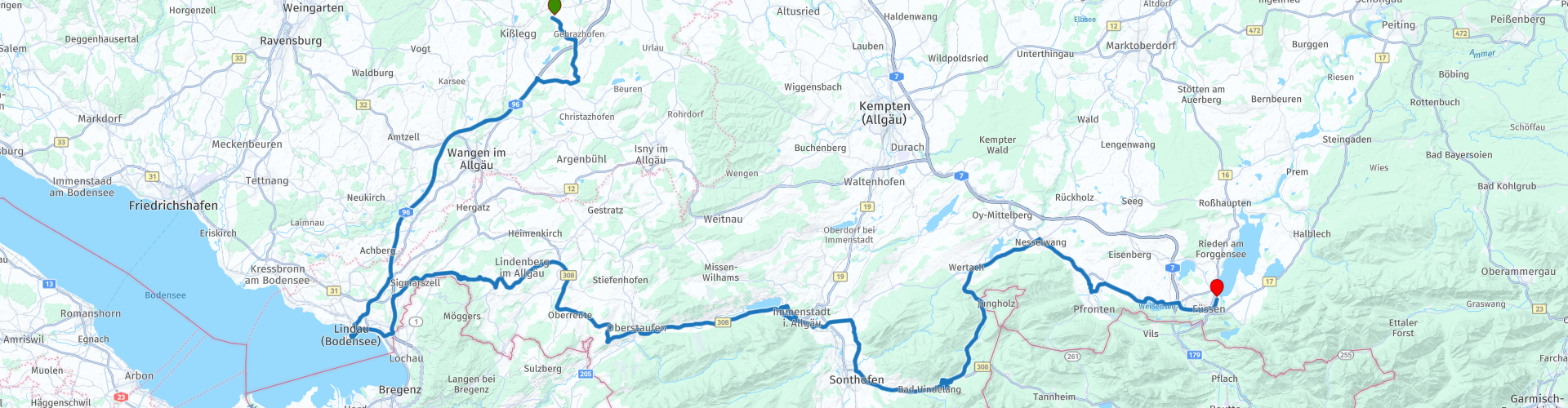
Kisslegg to Fussen

This route was brought to you by:
RouteXpert Marcel Scherpenkate
Last edit: 11-01-2024
 Route Summary
 The route has been equalized for TomTom, Garmin and MyRoute-app Navigation users.
I rate this route with the maximum number of 5 stars, I have been allowed to drive this route myself and it is a succession of diversity of landscape via beautiful roads connected by equally authentic villages and panoramic views. Wonderful to drive through.
 Share this route


Animation

Verdict


Duration
6h 44m

Mode of travel
Car or motorcycle

Distance
172.34 km

Countries


 RouteXpert Review
 If you like hats, the hat museum in Lindenberg im Allgäu is also a place to visit. The first hat factory was established during the Biedermeier period (1814-1840). By 1890 there were 34 straw hat manufacturers who together made about 8 million straw hats annually. It is therefore not surprising that Lindenberg was nicknamed 'Little Paris' in the early 1920s as the heart of the German straw hat industry. The hat museum gives a nice insight into the centuries-old tradition of hat making in the city. The route continues on the B308 where you have a fantastic view over the entire national Nagefluhkette park in good weather. On the ridge between Weiler and Simmerberg you can see not only the Allgäu and the Vorarl mountains in clear weather, but even the Swiss Santis massif. The Oberjoch pass road also starts at the village of Oberreute, this road takes you after an hour of steering in the small village of Bühl am Alpsee where there is the possibility to have lunch at the Großer Alpsee, the largest natural lake in the Allgäu. From Gasthof Alpsee it is worthwhile to walk through the small harbor towards the Alpsee with its long jetty on which you can walk tens of meters into the Alpsee. After this stop the route continues through the Oberallgäu and you drive via Immenstadt, Sonthofen to Bad Hindelang. Bad Hindelang is not only a modern ski resort (Oberjoch), but also a spa. Anyone suffering from allergies can breathe freely here with healthy air and untouched nature and enjoy a carefree holiday. Moreover, since 2011, more than 110 companies in Bad Hindelang have been recognized as 'allergy-friendly'. In 2019, the Bavarian 'Heilbäder-Verband' awarded Bad Hindelang the TÜV seal of 'health resort for allergy sufferers'. After Bad Hindelang, the Oberjoch pass road starts and is one of the most famous recreational routes in Bavaria. It is Germany's most winding road through the Alps. This part consists of 106 turns. The road is so well integrated into the farm landscape that it has become an inseparable part of it, just like the neighboring villages and mountains, really fantastic to drive. Tip: Do not forget to enjoy the beautiful view which is possible at one of the many parking spaces with fantastic views. Finally you arrive in Wertach at the Grüntensee, a 2.5 km long and 11.2 m deep reservoir with a circumference of 8.2 km. The reservoir was completed in 1962 and is used for flood protection and electricity generation. Pfronten, the next village on your route after Nesselwang, is dedicated to the healing power of hay. This comes exclusively from ungrazed and unfertilized mountain pastures that lie at an altitude of more than 900 meters. The inexhaustible healing power of the hay from the mountain pastures with seventy different types of herbs, grasses and medicinal plants is used in all kinds of ways.
Driving along the Weissenssee you can already see today's final destination, Füssen, the highest town in Bavaria. It is located on the River Lech at 833 meters above sea level. The city has 15,608 inhabitants. The romantic old town of Füssen has an Italian atmosphere. The squares and street cafes invite you to pay a visit after a day on the motorcycle. You drive through the city to hotel Sommer where you can spend the night at the Forgensee.


 Links
Links  Usage
Usage Want to download this route?
You can download the route for free without MyRoute-app account. To do so, open the route and click 'save as'. Want to edit this route?
No problem, start by opening the route. Follow the tutorial and create your personal MyRoute-app account. After registration, your trial starts automatically.  Disclaimer
Use of this GPS route is at your own expense and risk. The route has been carefully composed and checked by a MyRoute-app accredited RouteXpert for use on TomTom, Garmin and MyRoute-app Navigation.
Changes may nevertheless have occurred due to changed circumstances, road diversions or seasonal closures. We therefore recommend checking each route before use.
Preferably use the route track in your navigation system. More information about the use of MyRoute-app can be found on the website under 'Community' or 'Academy'.