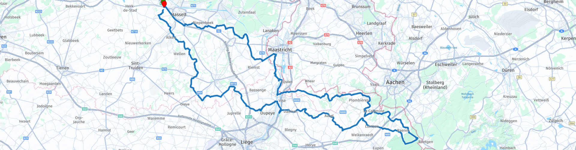
Roundtrip The Voer out of Hasselt

This route was brought to you by:
RouteXpert Guy Heyns - Adv. RouteXpert
Last edit: 10-12-2024
 Route Summary
 The route takes you, almost exclusively on B&C roads from Hasselt to and through the wonderful Voer region in Belgium.
The route is ideally suited for young motorcyclists whose (provisional) driving license does not yet allow to cross the country's borders, but still want to explore quite a bit of the road.
221 kilometers of pure fun await you. Thank you Frank!
 Share this route


Animation

Verdict


Duration
8h 58m

Mode of travel
Car or motorcycle

Distance
221.12 km

Countries


 RouteXpert Review
 No matter how rough the contradictions are and how bloody (take that literally) the battle - not so long ago - has been, the Voer still is so beautiful. Despite yesterday's history, today will be a very pleasant and beautiful ride.
The departure is, as always, in the car park of the Carrefour in Kuringen. Ideal place to meet, close to major arrival and departure routes, spacious meeting place, breakfast, lunch and dinner options and a picnic can be purchased.
A short drive on the motorway ensures that we can avoid the urban environment of Hasselt, and then dive into the delightful Limburg B-roads. The atmosphere immediately sets in, even after the gas station in Munsterbilzen (rp7) where the tank can be topped up if necessary.
It then remains pleasant to drive up to route point 10 where a possible first stop can be made, despite the fact that you actually have barely 40 kilometers on your wheels. But… if you are an ice cream lover, this stop at the 'Icecreamlovers' is highly recommended. And while you eat that delicious ice cream, you can immediately get a nice view of the Albert Canal that cuts deep through the marl mountains here. Also note the bunker on the other side of the road: it was completely moved when the new bridge was built. A sign that the region was very valuable here in times of war, but more about this later.
While the last drops of ice melt on the tongue, you can resume the route on the other side of the canal. You drive into Kanne, a village known for its cave mushrooms and Cave beer. Most of the hills you see here are usually completely hollowed out because they are built from the so-called marl stone, which was often used as a building material. Just notice the houses around you. You will probably find many yellow facades in which the stone was processed.
Spicy detail… you may have seen NOTHING, but that was the intention…. During the descent to Kanne, you passed a former NATO military headquarters. Completely buried in the hill next to the Albert Canal and completely invisible. Only the locals still know where to find the entrance….
At waypoint 11 we recommend that you take a short photo stop. Not only is the bridge over the Albert Canal a fine architectural masterpiece, the excavation of the canal itself between the 40-meter-high hill was a feat. And remember, the hills that you see to your left and right are also…. hollow. The entire region is undercut and tunneled here. There are corridors nearby that lead to Maastricht….
Just after crossing the bridge (rp12) you enter Wallonia. Still, be careful with the throttle, because you will be flirting with the Flemish-Walloon border for a while. And just to indicate one sign of difference: in Wallonia you are allowed 90 kilometers per hour outside the village center. In Flanders maximum 70. And the Flemish big brother boys in police uniform like to see you pass in front of their sensitive, and very strategically placed cameras…. So if you do not wish to receive an additional reminder of this trip - sold quite dearly by the Flemish government - it is best to hold back your right hand for a while.
At route point 13 we treat you with a look at the fortress of Eben-Emael. An example of Belgian incompetence… ..
The fortress of Eben-Emael, which was part of the fortress belt that was supposed to guard Belgium against the great invasion, has been completely excavated in the hill. In itself a good idea and, to be fair, had the fort's leadership not been handed over to an utter idiot, the course of the war might have been slightly different.
On May 10 at 4:25 am, the Germans launched their attack, which was prepared to perfection. The fort's cannons were unable to fire. The Confederate gun was not manned because men had been summoned to unload trucks downstairs, and the North gun was knocked out with only one so-called 'hollow' charge, destroying the entire gun and access to it by melting the steps leading to it. There was only one watchkeeper who ordered firing, but he was… without ammunition… .. he was still in the trucks. In addition, the ammunition elevator also refused, possibly also built on behalf of the government….
The fort, on which the aircraft could land up to 5 meters from the unarmed machine guns due to inefficient surveillance, was thus completely destroyed with the help of just one explosive. The Belgian inefficiency therefore had no chance against the 'Deutsche Grundlichkeit', which ensured that the entire territory around the Albert Canal was completely taken in two days. And you can take that Deutsche Grundligkeit literally. The German soldiers were so well prepared that they could even drive the Belgian trams without any problems. It was a matter of hours before the entire region was taken over by the German soldiers.
If you are interested in the military aspect of the region, you should also stop just after route point 14. There is a small, but nevertheless very interesting viewpoint there. Parking options are limited, but you will lose a small group of motorcycles for a while. The viewpoint offers you a view of the Albert Canal, the Maas and the three countries in the area. The Netherlands and the city of Maastricht on the left, The Belgian country at the bottom and Germany further away. The land you see here has been the bloody scene of a fierce battle between all kinds of countries since Napoleonic times. If you visit the region extensively, many other signs of this can be found outside the Fort of Eben-Emael.
At route point 15 you cross the Albert Canal, which receives additional power from the Maas just before the bridge. The Albert Canal is extremely important here because it opened up the entire region economically. After crossing the canal, you drive on land between the canal and the Maas and when you cross the Maas at route point 16, you enter Flanders again and enter the Voer region. A coffee break is provided at route point 17 where you can process the impressions you have already gained.
After the break you literally flirt with the Dutch border. Between rp 18 and 19 you literally drive on that border. If you pay attention you will see the boundary markers. You drive through Voeren and continue to do this until route point 21, where you are on Walloon territory, up to and including route point 45. From here you are allowed to accelerate a little more smoothly without being presented with the bill.
Route point 21 is also located in the forest reserve of the Teuvenerberg. It is very pleasant to stay and the views over the region are truly majestic. And especially when you drive down the Teuvenerberg and the Beusdael castle comes into view. An unforgettable impression will undoubtedly be yours. A photo stop has therefore been inserted on rp 22 where you can capture this fantastically beautiful castle on film. In addition, private property….
After the photo stop where it is best to dream away in the direction of the lord or lady of the castle, you should pay attention to the road again… the region is so beautiful, and not only for bikers. You will find many cyclists and walkers here on your way to rp 26 where you may find something to eat and drink in the village. 'Au Petit Café' offers you a small car park on the other side of the road, if of course there is room on the terrace.
At route point 30 you are not only in the Nature Park 'De Hoge Venen', which is part of the Eifel area, but you also touch the highest point on this route: you are 455 meters above sea level.
From here, the drive to Val-Dieu, a former Sistercine abbey, is very pleasant and allows you to enjoy a stroll on the motorbike, getting to know both the agricultural and the wooded side of the region. The very pointed tower of the Abbey of Val Dieu itself will see you for a while above the trees and then suddenly appear in front of you. The church may have been rebuilt five times, each time back to the original plans, but the abbey itself is still in its original state. Beer is also still brewed, but despite the fact that this was also a Cistercian abbey, it is not a Trappist beer, but one of the 23 abbey beers in the country. Does not matter for the taste, of course, because the many variations of the Val Dieu are particularly popular with many ...
On the assumption that you still prefer to put the Val Dieu in the top case rather than in yourself, but assuming that you still have a 'thirst', we have made a short stop again on rp 38. Shortly afterwards you will cross the Maas and the Albert Canal back, as well as the border with Flanders. Note the changed speed limits!
The curve around Tongeren, the oldest city in Flanders, and the way back to Kuringen are also more than worth the drive. So it remains to enjoy for a while on this last stretch of the route that definitely deserves the five-star rating. The quality of the road, the views, the nature, the history and the wonderful break points are absolutely the cause of this.
And no matter how turbulent the region you just drove through, the Limburg landscape is so peaceful. You will therefore arrive completely relaxed at the starting point, which also serves as the end point. In one of the available restaurants you have the chance to say goodbye to your comrades ...


 Links
Links  Usage
Usage Want to download this route?
You can download the route for free without MyRoute-app account. To do so, open the route and click 'save as'. Want to edit this route?
No problem, start by opening the route. Follow the tutorial and create your personal MyRoute-app account. After registration, your trial starts automatically.  Disclaimer
Use of this GPS route is at your own expense and risk. The route has been carefully composed and checked by a MyRoute-app accredited RouteXpert for use on TomTom, Garmin and MyRoute-app Navigation.
Changes may nevertheless have occurred due to changed circumstances, road diversions or seasonal closures. We therefore recommend checking each route before use.
Preferably use the route track in your navigation system. More information about the use of MyRoute-app can be found on the website under 'Community' or 'Academy'.

Belgian Limburg
About this region
Limburg (, Dutch pronunciation: [ˈlɪmbʏr(ə)x] (listen); Dutch: Limburg; Limburgish: Limburg; French: Limbourg) is a province in Belgium. It is the easternmost of the five Dutch-speaking provinces that together form the Region of Flanders, one of the three main political and cultural sub-divisions of modern Belgium.
Limburg is located west of the Meuse (Dutch: Maas), which separates it from the similarly-named Dutch province of Limburg. To the south it also shares a border with the French-speaking province of Liège, with which it also has historical ties. To the north and west are the old territories of the Duchy of Brabant. Today these are the Flemish provinces of Flemish Brabant and Antwerp to the west, and the Dutch province of North Brabant to the north.
The province of Limburg has an area of 2,427 km2 (937 sq mi) which comprises three arrondissements (arrondissementen in Dutch) containing 44 municipalities. Among these municipalities are the current capital Hasselt, Sint-Truiden, Genk, and Tongeren, the only Roman city in the province, and regarded as the oldest city of Belgium. As of January 2019, Limburg has a population of 874,048.The municipality of Voeren is geographically detached from Limburg and the rest of Flanders, with the Netherlands to the north and the Walloon province of Liège to the south. This municipality was established by the municipal reform of 1977 and on 1 January 2008 with its six villages had a total population of 4,207. Its total area is 50.63 km2 (19.55 sq mi).
Read more on Wikipedia
Limburg is located west of the Meuse (Dutch: Maas), which separates it from the similarly-named Dutch province of Limburg. To the south it also shares a border with the French-speaking province of Liège, with which it also has historical ties. To the north and west are the old territories of the Duchy of Brabant. Today these are the Flemish provinces of Flemish Brabant and Antwerp to the west, and the Dutch province of North Brabant to the north.
The province of Limburg has an area of 2,427 km2 (937 sq mi) which comprises three arrondissements (arrondissementen in Dutch) containing 44 municipalities. Among these municipalities are the current capital Hasselt, Sint-Truiden, Genk, and Tongeren, the only Roman city in the province, and regarded as the oldest city of Belgium. As of January 2019, Limburg has a population of 874,048.The municipality of Voeren is geographically detached from Limburg and the rest of Flanders, with the Netherlands to the north and the Walloon province of Liège to the south. This municipality was established by the municipal reform of 1977 and on 1 January 2008 with its six villages had a total population of 4,207. Its total area is 50.63 km2 (19.55 sq mi).
View region
 Statistics
  65
65Amount of RX reviews (Belgian Limburg)
 44559
44559Amount of visitors (Belgian Limburg)
 16624
16624Amount of downloads (Belgian Limburg)
 Route Collections in this region
 The 10 most beautiful car and motorcycle routes in North Brabant
Brabant, Brabant conviviality, bon vivants and who does not know the song by Guus Meeuwis about Brabant? "And then I think of Brabant, because there is still light burning there" and that is true, because the City of Light is in Brabant, in Eindhoven that is, but Eindhoven is also known as the match city of the Netherlands. The annual light festival (GLOW) in Eindhoven shows breathtaking lighting techniques, something you must see once.
But not only light, matches and Brabant cosiness in Brabant, but also a very beautiful province to tour by car or motorcycle and enjoy all the beauty that the province of Brabant has to offer. For this, the MyRoute app RouteXpert has put together a Top 10 of Car and Motorcycle routes for you.
All routes in this collection have been checked and made equal for TomTom, Garmin and MyRoute-app Navigation by a MyRoute-app RouteXpert.
If you think, I have a very nice route that should certainly not be missing from this collection, send it to:
email: routeexpert@myrouteapp.com
Subject: New Route for the Top 10 collection Province of Brabant composed by Hans van de Ven.
The route will then be reviewed and then added to the Top 10.
To make the Top 10 also the Top 10, 1 route will have to disappear from the Top 10, you can indicate this when submitting the new route.
Have fun with this collection and while driving one of these routes. Enjoy all the beauty that the Netherlands and in particular the province of Brabant has to offer. Click on “View route” to read the review of the chosen route.
I would like to hear your findings about the route(s).
View Route Collection
The 10 most beautiful car and motorcycle routes in Limburg
Limburg, who thinks of Limburg, thinks of flan, coal mines, marl and the hill country. The coal mines have been closed for almost 40 years, the last load of coal was brought up from the Oranje-Nassau coal mine in Heerlen on 31 December and, as they say, South Limburg was transformed from Black to Green and unfortunately there is still little left. view of this period.
But not only pie, marl and coal in Limburg, but also a very beautiful province to tour by car or motorcycle and enjoy all the beauty that the province of Limburg has to offer. For this, the MyRoute app RouteXpert has put together a Top 10 of Car and Motorcycle routes for you.
All routes in this collection have been checked and made equal for TomTom, Garmin and MyRoute-app Navigation by a MyRoute-app RouteXpert.
If you think, I have a very nice route that should certainly not be missing from this collection, send it to:
email: routeexpert@myrouteapp.com
Subject: New Route for the Top 10 collection Province of Limburg composed by Hans van de Ven.
The route will then be reviewed and then added to the Top 10.
To make the Top 10 also the Top 10, 1 route will have to disappear from the Top 10, you can indicate this when submitting the new route.
Have fun with this collection and while driving one of these routes. Enjoy all the beauty that the Netherlands and in particular the province of Limburg has to offer. Click on “View route” to read the review of the chosen route.
I would like to hear your findings about the route(s).
View Route Collection