Roundtrip from Landegem along testimonies of World War I and II

This route was brought to you by:
RouteXpert Catherine De Groote RouteXpert
Last edit: 01-05-2021
 Route Summary
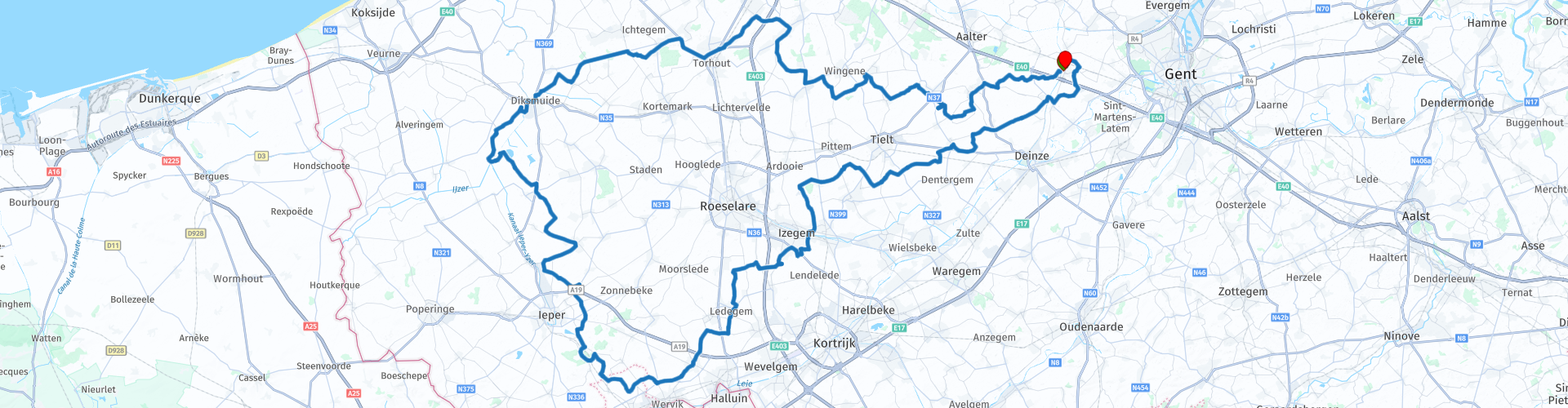
 Start and end point is located in the East Flemish Landegem, part of the municipality of Deinze. The route goes via Wingene and Tornhout to Diksmuide along quiet rural roads, which are largely in very good condition. You drive back to the starting point via Ypres and Roeselare.
This route therefore gets 5 points.
 Share this route


Animation

Verdict


Duration
9h 57m

Mode of travel
Car or motorcycle

Distance
207.94 km

Countries

 RouteXpert Review
 The castle park of Poeke is a wooded park of 56 hectares with an absolutely beautiful castle in neoclassical style. The gardens are open daily from sunrise to sunset.
In Estaminet De Flasse you can stop and enjoy a drink or snack.
In Torhout you pass the Wijnendale castle that can be visited. There is a car park at the entrance of the castle park. The historic moated castle Wijnendale Castle to the north of the city center, surrounded by 180 hectares of forest, houses the glorious past from the 11th century to the present day. The museum shows you life in the castle and tells you the stories about Leopold III during the May days 1940, the counts of Flanders and dukes of Burgundy. The castle can be visited both individually and in groups. Admission price for adults is € 5. Opening hours: April to June and September: Wednesday and Sunday 1.30 to 5.30 pm - July and August Wednesday to Sunday 1.30 to 5.30 pm
The tour continues to Diksmuide. On the Grote Markt you can easily park and eat or drink something in the various restaurants. A must is certainly the Eethuis and frituur 't Belfort. Just over the Yser you will pass the Yser Tower. This tower, originally inaugurated on August 24, 1930, stands on the bank of the river Yser, near the city center of Diksmuide on the territory of the Kaaskerke district. On the four sides of the monumental base on the tower is written No more war, in the four languages of the warring factions of the Western Front during the First World War: Plus jamais de guerre, No more War, Nie wieder Krieg.
The Yser Tower is primarily a memorial to the Flemish fallen of the First World War, but at the same time it is also a symbol of the will, which arose along the Yser, for more political independence in Flanders.
The 22 floors of the Yser Tower are designed as a museum about War, Peace and Flemish emancipation. It has been part of the United Nations Peace Museums Network since 1998.
More information about visiting the Yser Tower can be found at the links at the bottom.
In the vicinity of Langemark-Poelkapelle you come to the Welsh memorial park. The red dragon, built on a dolmen ("cromlech" in Welsh), stands at the center of an area captured by a Welsh force on July 31, 1917. He looks towards Passchendaele, the village that would be taken three months later. This would kill half a million people. The surrounding park is dedicated to all the Welsh people, both soldiers and civilians, who were involved in the First World War. The monument is hidden behind a hedge, but there is a small car park.
A little further you will notice the Northumbrian Division Memorial. In all its simplicity, the sturdy monumental obelisk was not only to form a beacon in the flat, Flemish landscape, it also had to refer to the county in Northern England, where the division was recruited.
The Saint-Charles de Potyze cemetery is a French military cemetery with war dead from the First World War, located in the Belgian city of Ypres. Some 4,800 dead are commemorated, of which more than 1,300 could not be identified. The cemetery covers an area of approximately 29,900 m² and is located about three kilometers northeast of the city center, along the road to Zonnebeke (N332), just past the hamlet of Potyze. The entrance to the cemetery is flanked by two white stone columns. To the left, past the entrance, is a group of statues representing a calvary. At the back is a mass grave and an obelisk commemorating a number of infantry regiments. The tombs are marked with upright crosses, with the exception of some Muslim and Jewish tombs which have a stone tombstone with an inscription according to their beliefs.
Hill 60 is a hill just outside the Belgian village of Zillebeke, where fierce battles took place during the First World War. The hill is located near the Ieper-Kortrijk railway (Spoorlijn 69), along Zwarteleenstraat. The hill is approximately 60 meters high and 230 meters long. This hill was actually built from soil that was released during the construction of 'the' railway. The war site of Hill 60 has been preserved and can be visited freely. There is a small parking lot directly at the entrance.
In Vinkt, a district of Deinze, during the Eighteen Days' Campaign in May 1940, a massacre took place on the civilian population by the German army. Within a few days, 140 civilians were killed in Vinkt and Meigem, of which 86 people were executed and 27 civilians died in the church of Meigem as a result of a grenade explosion. The victims came from Vinkt and neighboring municipalities. A memorial monument has been erected at the church, consisting of a wall of honor with a monument, a wrought entrance gate, a monument of crosses and a memorial altar. Since 2013, a reflection room has also been housed in a separate wing of the Sint-Franciscus residential and care center. You can park along the Heerdweg and on the Martelarenplein. You can reach this square by turning right 100 m past the primary school into a narrow street on the traffic plateau.
From there it is about 15 km to the end of this route at the church of Landegem. There you can end the day at café De Gouden Klok or on the other side of the church at Brasserie De Lork where we started the route. In summer you can also enjoy a delicious pastry with coffee or taste the homemade ice cream on the terrace at the Aristo bakery.
This route gets 5 points. There are many commemorative monuments of the First World War between Diksmuide and Ypres. In Vinkt, the monument is a reminder of the massacre that took place in May 1940. The route follows quiet rural roads that are largely also in very good shape.


 Links
Links  Usage
Usage Want to download this route?
You can download the route for free without MyRoute-app account. To do so, open the route and click 'save as'. Want to edit this route?
No problem, start by opening the route. Follow the tutorial and create your personal MyRoute-app account. After registration, your trial starts automatically.  Disclaimer
Use of this GPS route is at your own expense and risk. The route has been carefully composed and checked by a MyRoute-app accredited RouteXpert for use on TomTom, Garmin and MyRoute-app Navigation.
Changes may nevertheless have occurred due to changed circumstances, road diversions or seasonal closures. We therefore recommend checking each route before use.
Preferably use the route track in your navigation system. More information about the use of MyRoute-app can be found on the website under 'Community' or 'Academy'.

Wallonia
About this region
The Walloon Region (French: Région wallonne [ʁeʒjɔ̃ walɔn]; German: Wallonische Region; Dutch: Waals gewest), usually simply referred to as Wallonia (; French: Wallonie [walɔni]; Walloon: Waloneye; German: Wallonien [vaˈloːni̯ən] (listen) or Wallonie [valoˈniː]; Dutch: Wallonië [ʋɑˈloːnijə] (listen)), is one of the three Regions of Belgium—alongside the Flemish Region and the Brussels-Capital Region.Covering the southern portion of the country, Wallonia is primarily French-speaking, and accounts for 55% of Belgium's territory, but only a third of its population. The Walloon Region was not merged with the French Community of Belgium, which is the political entity responsible for matters related mainly to culture and education, because the French Community of Belgium encompasses both Wallonia and the bilingual Brussels-Capital Region.
There is a German-speaking minority in eastern Wallonia, resulting from the annexation of three cantons previously part of the German Empire at the conclusion of World War I. This community represents less than 1% of the Belgian population. It forms the German-speaking Community of Belgium, which has its own government and parliament for culture-related issues.
During the industrial revolution, Wallonia was second only to the United Kingdom in industrialization, capitalizing on its extensive deposits of coal and iron. This brought the region wealth, and from the beginning of the 19th to the middle of the 20th century, Wallonia was the more prosperous half of Belgium. Since World War II, the importance of heavy industry has greatly diminished, and the Flemish Region has exceeded Wallonia in wealth as Wallonia has declined economically. Wallonia now suffers from high unemployment and has a significantly lower GDP per capita than Flanders. The economic inequalities and linguistic divide between the two are major sources of political conflicts in Belgium and a major factor in Flemish separatism.
The capital of Wallonia is Namur, and the most populous city is Charleroi. Most of Wallonia's major cities and two-thirds of its population lie along the east-west aligned Sambre and Meuse valley, the former industrial backbone of Belgium. To the north of this valley, Wallonia lies on the Central Belgian Plateau, which, like Flanders, is a relatively flat and agriculturally fertile area. The south and southeast of Wallonia is made up of the Ardennes, an expanse of forested highland that is less densely populated.
Wallonia borders Flanders and the Netherlands (the province of Limburg) in the north, France (Grand Est and Hauts-de-France) to the south and west, and Germany (North Rhine-Westphalia and Rhineland-Palatinate) and Luxembourg (Capellen, Clervaux, Esch-sur-Alzette, Redange and Wiltz) to the east. Wallonia has been a member of the Organisation Internationale de la Francophonie since 1980.
Read more on Wikipedia
There is a German-speaking minority in eastern Wallonia, resulting from the annexation of three cantons previously part of the German Empire at the conclusion of World War I. This community represents less than 1% of the Belgian population. It forms the German-speaking Community of Belgium, which has its own government and parliament for culture-related issues.
During the industrial revolution, Wallonia was second only to the United Kingdom in industrialization, capitalizing on its extensive deposits of coal and iron. This brought the region wealth, and from the beginning of the 19th to the middle of the 20th century, Wallonia was the more prosperous half of Belgium. Since World War II, the importance of heavy industry has greatly diminished, and the Flemish Region has exceeded Wallonia in wealth as Wallonia has declined economically. Wallonia now suffers from high unemployment and has a significantly lower GDP per capita than Flanders. The economic inequalities and linguistic divide between the two are major sources of political conflicts in Belgium and a major factor in Flemish separatism.
The capital of Wallonia is Namur, and the most populous city is Charleroi. Most of Wallonia's major cities and two-thirds of its population lie along the east-west aligned Sambre and Meuse valley, the former industrial backbone of Belgium. To the north of this valley, Wallonia lies on the Central Belgian Plateau, which, like Flanders, is a relatively flat and agriculturally fertile area. The south and southeast of Wallonia is made up of the Ardennes, an expanse of forested highland that is less densely populated.
Wallonia borders Flanders and the Netherlands (the province of Limburg) in the north, France (Grand Est and Hauts-de-France) to the south and west, and Germany (North Rhine-Westphalia and Rhineland-Palatinate) and Luxembourg (Capellen, Clervaux, Esch-sur-Alzette, Redange and Wiltz) to the east. Wallonia has been a member of the Organisation Internationale de la Francophonie since 1980.
View region
 Statistics
  80
80Amount of RX reviews (Wallonia)
 22322
22322Amount of visitors (Wallonia)
 18827
18827Amount of downloads (Wallonia)
 Route Collections in this region
 The 10 most beautiful car and motorcycle routes in Limburg
Limburg, who thinks of Limburg, thinks of flan, coal mines, marl and the hill country. The coal mines have been closed for almost 40 years, the last load of coal was brought up from the Oranje-Nassau coal mine in Heerlen on 31 December and, as they say, South Limburg was transformed from Black to Green and unfortunately there is still little left. view of this period.
But not only pie, marl and coal in Limburg, but also a very beautiful province to tour by car or motorcycle and enjoy all the beauty that the province of Limburg has to offer. For this, the MyRoute app RouteXpert has put together a Top 10 of Car and Motorcycle routes for you.
All routes in this collection have been checked and made equal for TomTom, Garmin and MyRoute-app Navigation by a MyRoute-app RouteXpert.
If you think, I have a very nice route that should certainly not be missing from this collection, send it to:
email: routeexpert@myrouteapp.com
Subject: New Route for the Top 10 collection Province of Limburg composed by Hans van de Ven.
The route will then be reviewed and then added to the Top 10.
To make the Top 10 also the Top 10, 1 route will have to disappear from the Top 10, you can indicate this when submitting the new route.
Have fun with this collection and while driving one of these routes. Enjoy all the beauty that the Netherlands and in particular the province of Limburg has to offer. Click on “View route” to read the review of the chosen route.
I would like to hear your findings about the route(s).
View Route Collection
Top 5 Car and Motorcycle Routes in the Eifel
The Eifel is the eastern part of the medium plateau Eifel-Ardennes. It is located north of the Moselle and west of the Rhine. The largest part is in Germany, a small part is in Belgium, in the East Cantons. The German part of Eifel is located in the federal states of North Rhine-Westphalia and Rhineland-Palatinate. The highest point is the Hohe Acht with 747 meters.
Several chains can be distinguished in the Eifel:
The northernmost part is called the Nordeifel, which in Belgium connects to the High Fens;
To the east of this is the Ahrgebirge, this part is located north of the Ahr in the Ahrweiler district;
South of the Ahr is the Hohe Eifel (or Hocheifel), of which the Hohe Acht (747 m) is the highest point, and also the highest point in the entire Eifel region;
To the west, near the Belgian border, the hills are known as Schneifel, part of the wider Snow Eifel area with peaks reaching up to 698 metres;
South and east of the Hohe Eifel is the Volcano-Eifel, a volcanic area with many crater lakes (Maare).
The southern part of the Eifel is less high. The area is bisected by streams and rivers running southwards. These streams flow into the Moselle. The largest of these rivers is the Kyll; the hills around this river are known as the Kyllwald;
In the south, the Eifel ends in the Voreifel.
In the north of the Eifel there are some large reservoirs. The largest of these is the reservoir in the Roer that was created by the construction of the Roerdal dam.
The Nürburgring is also located in the Eifel, a well-known car circuit for Formula 1 races, among other things. Since 2004, part of the north of the Eifel has become the Eifel National Park. This National Park falls entirely within the German-Belgian nature park High Fens-Eifel. Another part of the Eifel falls within the South Eifel Nature Park.
Well-known throughout the Netherlands and Belgium by car and motorcyclists, so reason enough for the MyRoute app RouteXpert to compile a Top 5 of Car and Motorbike routes for you.
All routes in this collection have been checked and made equal for TomTom, Garmin and MyRoute-app Navigation by a MyRoute-app RouteXpert.
If you think, I have a very nice route that should certainly not be missing from this collection, send it to:
email: routeexpert@myrouteapp.com
Subject: New Route for the Top 5 collection Eifel composed by Hans van de Ven.
The route will then be reviewed and then added to the Top 5. To make the Top 5 also the Top 5, 1 route will have to disappear from the Top 5, you can indicate this when submitting the new route.
Have fun with this collection and while driving one of these routes. Enjoy all the beauty that the Eifel has to offer. Click on “View route” to read the review of the chosen route.
I would like to hear your findings about the route(s).
View Route Collection