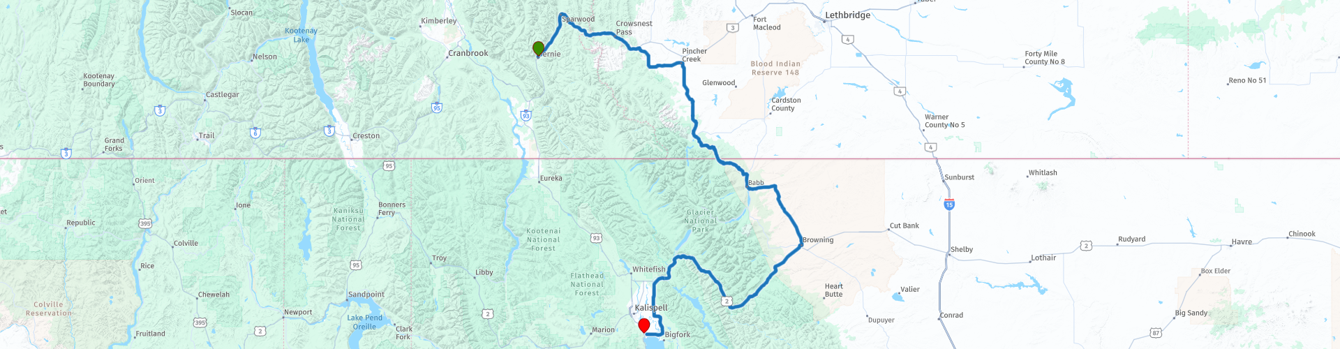
D07 Fernie Kalispell

This route was brought to you by:
RouteXpert Hans van de Ven (Mr.MRA)
Last edit: 16-10-2019
 Route Summary
 The roads are very good, the surroundings are beautiful, one of the ranches along the way must be photographed and a stop in the Glacier National Park is a must.
Starting point: Best Western Plus Fernie Mountain Lodge
End point: Best Western Plus Flathead Lake Inn and Suites
The route has been made the same for TomTom, Garmin and MyRoute-app Navigation users.
Thanks to Richard & Lisa for the information!
 Share this route


Animation

Verdict


Duration
5h 14m

Mode of travel
Car or motorcycle

Distance
448.08 km

Countries


 RouteXpert Review
 on the edge of the Rocky Mountains and a little less than 60 kilometers south of Waterton Lakes National Park, so there is a lot of beautiful nature in the area.
In Pincher Creek you often have to deal with a chinook: a dry and strong wind that is typical of the area around the Rocky Mountains. The wind 'falls' from the mountains, so to speak, so that it can blow very hard. The region has responded to this by installing many wind turbines. Along the way we arrive at Waterton Lake which consists of two parts that are connected by a narrow channel (locally known as the Bosphorus). The two parts are called Lower and Upper Waterton Lake. The Lower Lake is entirely in the Canadian area, the Upper Lake is partly in Glacier National Park in the US and is the deepest lake in the Canadian Rockies (148 meters).
Over the Logan Pass we reach the Glacier National Park with its many beautiful passes and dozens of large and small lakes. The primary road in the park is the Going-to-the-Sun Road, which crosses the park from east to west and takes you past the most important sights. In the winter months the road is closed due to snowfall, but in the months that the road is open, you can drive there with your own transport. Kalispell, located in northwestern Montana, is one of the most important places in that state and owes its fame to its location near the Glacier National Park. Today, Kalispell is the third largest city in Montana and the most important commercial center of the northwestern state.
In this 4-star route you will drive on beautiful good roads, and through beautiful surroundings, the Sinclair Pass, the Glacier National Park with the many lakes where you will certainly stop 1 or more times.
History:
Kalispell was founded in 1891 by businessman and banker Charles E. Conrad. Conrad was friends with James J. Hill, the founder of the Great Northern Railway who wanted to connect St. Paul in Minnesota to the Pacific Ocean. Hill wanted to create a stop along the track at the Flathead Valley in Montana, which was an empty area at the time. Conrad accepted the assignment and founded a settlement with his own money. In 1891 the sale of building plots began in Kalispell.
In the course of the twentieth century, the population of Kalispell continued to grow steadily, despite the fact that the Great Northern Railway was moved north in 1904. Because Kalispell was the capital of Flathead County, the city remained attractive to many companies and institutions. For many years there was a lot of wood industry around the city and after the opening of the Glacier National Park in 1910 tourism also got going.


 Links
Links  Usage
Usage Want to download this route?
You can download the route for free without MyRoute-app account. To do so, open the route and click 'save as'. Want to edit this route?
No problem, start by opening the route. Follow the tutorial and create your personal MyRoute-app account. After registration, your trial starts automatically.  Disclaimer
Use of this GPS route is at your own expense and risk. The route has been carefully composed and checked by a MyRoute-app accredited RouteXpert for use on TomTom, Garmin and MyRoute-app Navigation.
Changes may nevertheless have occurred due to changed circumstances, road diversions or seasonal closures. We therefore recommend checking each route before use.
Preferably use the route track in your navigation system. More information about the use of MyRoute-app can be found on the website under 'Community' or 'Academy'.