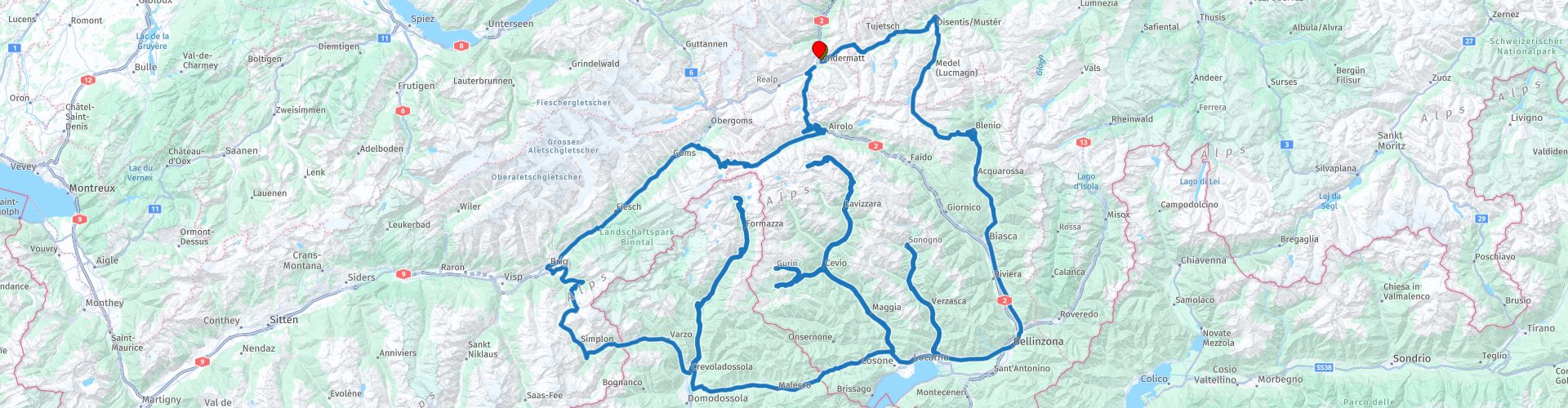
Rondje Wallis en Tessin vanuit Andermatt

This route was brought to you by:
RouteXpert Hans van de Ven (Mr.MRA)
Last edit: 11-02-2023
 Route Summary
 Start: Andermatt
Finish: Andermatt
The route made the same for TomTom, Garmin and MyRoute-app Navigation users.
If you want to ride this TT, keep the info below in mind:
- If you drive all alternatives, a three-day tour is recommended.
- Average mountain experience
- Tour
- Accommodation necessary
Source: Promoter 07, September / October 2018.
 Share this route


Animation

Verdict


Duration
14h 0m

Mode of travel
Car or motorcycle

Distance
703.85 km

Countries


 RouteXpert Review
 - Passes and mountain roads: Oberalp pass (2040 m), Lukmanier pass (1916 m), Simplon pass (2005 m), Nufenen pass (2478 m), St. Gotthard pass (2108 m), Furka pass (2431 m), mountain road around Lago del Narèt ( 2310 m) at the end of Val Sambuco, mountain road to Lago di Tóggia (2170 m) at the end of Val Antigório
Route details:
- Winter closure: Oberalp pass and St. Gotthard (Tremolastraße) November to May, Lukmanier pass December to April, Nufenen pass October to June, Furka pass October to May; the mountain roads to Lago del Narét and Lago di Tóggia are generally accessible between June and October
- Ideal travel time: Due to all winter closures, the tour can only be done in the months of June to October.
- Roads: The alternative routes are partially unpaved.
- Driving pleasure: the Centovalli is really a dream if you like turns. Simplon pass, the road to the Simplon and Nufenen pass, St. Gotthard / Tremolaweg and Furka pass.
- Landscape: Stunning nature. Furka pass and the alternatives in the Ticino valleys
This 5-star route is one of the 24 most beautiful Alpine routes in recent years!
Colored route points:
rp 1 - Starting point in Andermatt near Bergidyll
rp 4 - Oberalp Pass
rp 9 - Passo del Lucomagno
rp 11 - Coffee stop at Lucomagno
rp 21 - Lunch stop at Ristorante Alpino
rp 22 - Fuel stop at ENI
rp 27 - View / photo point at Lago del Naret
rp 28 - Coffee stop at Il Medico
rp 29 - Possibility to spend the night at Hotel Walser
rp 31 - Possibility to spend the night at Albergo della Posta
rp 33 - Coffee stop at Osteria Grütli
rp 36 - Photo point at Lago Morasco, watch out partly unpaved.
rp 37 - Coffee stop at Bärulussa
rp 40 - Refueling and lunching at ENI and Siesta
rp 41 - Simplon Pass
rp 42 - Difference in route when using TT and Here card, this is solved at rp 43
rp 47 - Tank option at BP
rp 51 - Coffee stop at Nufenen-Passhöhe
rp 52 - Nufenenpass / Passo della Novena
rp 57 - Passo del San Gottardo
rp 60 - End point in Andermatt near Bergidyll


 Links
Links  Usage
Usage Want to download this route?
You can download the route for free without MyRoute-app account. To do so, open the route and click 'save as'. Want to edit this route?
No problem, start by opening the route. Follow the tutorial and create your personal MyRoute-app account. After registration, your trial starts automatically.  Disclaimer
Use of this GPS route is at your own expense and risk. The route has been carefully composed and checked by a MyRoute-app accredited RouteXpert for use on TomTom, Garmin and MyRoute-app Navigation.
Changes may nevertheless have occurred due to changed circumstances, road diversions or seasonal closures. We therefore recommend checking each route before use.
Preferably use the route track in your navigation system. More information about the use of MyRoute-app can be found on the website under 'Community' or 'Academy'.

Valais
About this region
Valais (in French) (UK: VAL-ay, US: val-AY, French: [valɛ] (listen); Arpitan: Valês), or Wallis (in German) (German: Wallis [ˈvalɪs] (listen)), more formally the Canton of Valais, is one of the 26 cantons forming the Swiss Confederation. It is composed of thirteen districts and its capital and largest city is Sion. The flag of the canton is made of thirteen stars representing the districts, on a white-red background.
Valais is situated in the southwestern part of the country. It borders the cantons of Vaud and Bern to the north, the cantons of Uri and Ticino to the east, as well as Italy to the south and France to the west. It is one of the three large southern Alpine cantons, along with Ticino and the Grisons. It is a bilingual canton, French and German being its two official languages. Traditionally, the canton is divided into Lower, Central and Upper Valais, the latter region constituting the German-speaking minority.
Valais essentially coincides with the valley of the Rhône from its headwaters to Lake Geneva, separating the Pennine Alps from the Bernese Alps. A major wine region, the canton is simultaneously one of the driest regions of Switzerland in its central Rhône valley and among the wettest, having large amounts of snow and rain up on the highest peaks found in Switzerland, such as Monte Rosa and the Finsteraarhorn. Although a major hydroelectricity producer, Valais is essentially renowned for its tourism industry and for its numerous Alpine resort towns, notably Crans-Montana, Saas Fee, Verbier and Zermatt. Overlooking the latter town, the Matterhorn has become an iconic landmark of the canton.
In 1529, Valais became an associate member of the Swiss Confederation. After having resisted the Protestant Reformation and remained faithful to the Roman Catholic Church, it became a republic under the guidance of the prince-bishop of Sion in 1628. In 1815, Valais finally entered the Swiss Confederation as a canton.
Read more on Wikipedia
Valais is situated in the southwestern part of the country. It borders the cantons of Vaud and Bern to the north, the cantons of Uri and Ticino to the east, as well as Italy to the south and France to the west. It is one of the three large southern Alpine cantons, along with Ticino and the Grisons. It is a bilingual canton, French and German being its two official languages. Traditionally, the canton is divided into Lower, Central and Upper Valais, the latter region constituting the German-speaking minority.
Valais essentially coincides with the valley of the Rhône from its headwaters to Lake Geneva, separating the Pennine Alps from the Bernese Alps. A major wine region, the canton is simultaneously one of the driest regions of Switzerland in its central Rhône valley and among the wettest, having large amounts of snow and rain up on the highest peaks found in Switzerland, such as Monte Rosa and the Finsteraarhorn. Although a major hydroelectricity producer, Valais is essentially renowned for its tourism industry and for its numerous Alpine resort towns, notably Crans-Montana, Saas Fee, Verbier and Zermatt. Overlooking the latter town, the Matterhorn has become an iconic landmark of the canton.
In 1529, Valais became an associate member of the Swiss Confederation. After having resisted the Protestant Reformation and remained faithful to the Roman Catholic Church, it became a republic under the guidance of the prince-bishop of Sion in 1628. In 1815, Valais finally entered the Swiss Confederation as a canton.
View region
 Statistics
  20
20Amount of RX reviews (Valais)
 15016
15016Amount of visitors (Valais)
 1343
1343Amount of downloads (Valais)
 Route Collections in this region
 The 24 Most Beautiful Alpine Routes
The Alps, The Alps are a mountain range in Europe, stretching from the French Mediterranean coast in the southwest to the Pannonian Plain in the east. The area of the mountain range is more than 200,000 km².
In other words Passes and Mountain Roads!
Driving through the mountains is great! Especially over the mountain passes with hairpin bends and narrow winding roads. Every bend a different view where you can enjoy. There are many beautiful mountain passes in the Alps.
A selection that has also been incorporated into these routes:
The Stlevio Pass:
The Stelvio Pass, also known as Passo dello Stelvio, is mainly known for the stage in the Giro d'Italia. Due to the length and the difference in height, this pass is seen as one of the toughest tests in cycling. The Stelvio Pass reaches a maximum height of 2758 meters and is therefore one of the highest in the Alps. The pass connects the towns of Bormio and Prato Allo Stelvio. In winter the pass is closed due to heavy snowfall.
The Reschenpass:
The Reschenpass, also known as Passo di Resia, connects the Austrian state of Tyrol with the Italian province of South Tyrol. The pass reaches a maximum height of 1,504 meters and has been one of the most important north-south connections in the Alps in recent centuries. The pass was used long before Roman times. Along the way you will pass several highlights and historical relics. One of the highlights is the Reschensee. This lake was created after the construction of the dam and has completely submerged the village of Graun. The only thing that reminds of that is the clock tower in the middle of the lake.
Col du Galibier:
The French mountain pass Col du Galibier connects the towns of Saint-Michel-de-Maurienne and Briançon via the Col du Lautaret in the south and the Col du Télégraphe in the north. The mountain pass is part of the Tour de France and very much feared, due to the fact that it can only be reached via the other two mountain passes. The pass reaches a maximum height of 2646 meters. From there you can take a walk to the viewpoint at 2704 meters. You can admire the peaks of the Grand Galibier, Mont Blanc and La Meije here.
The Grossglockner High Alpine Road:
With a height of 3798 meters the Grossglockner is the highest mountain in Austria. To fully enjoy this impressive mountain, you can drive over the Grossglockner High Alpine Road and the accompanying pass. The route starts from Bruck am Grossglockner and ends in Heiligenblut. Of course you can drive in two directions. The pass reaches a maximum height of 2504 meters and is closed in winter due to heavy snowfall. Along the way you pass several stops with fun activities, information points, mountain huts and viewpoints. A visit to the Kaiser-Franz-Josefs-Höhe and Pasterzen Glacier is highly recommended.
The Col d'Izoard:
Just like the Col du Galibier, the Col d'Izoard is also part of a stage of the Tour de France. The mountain pass connects Briançon with the valley of the river Guil. The pass is partly located in the Regional Natural Park du Queyras and reaches a maximum height of 2360 meters. What is special about the Col d'Izoard is the barren and rocky landscape. Sometimes it feels like driving a car over the moon! Along the way you can stop at several points to enjoy the beautiful view.
The Bernina Pass:
The Bernina Express is one of the most famous rail trains in Switzerland and the Alps. The route is beautiful and partly included on the UNESCO World Heritage List. Parallel to the railway lies the Bernina pass, which connects the Veltlin valley with the Egandin valley. This beautiful Alpine road has a total length of 56 kilometers and reaches a maximum height of 2328 meters. Along the way you can enjoy views of the Morteratsch Glacier.
The Sella Pass:
The Sella Pass, also known as Passo di Sella, takes you over one of the most impressive mountain ranges in the Dolomites: the Sella massif. The pass connects Valle di Fassa with Val Gardena and reaches a maximum height of 2236 meters. At this height is also the border of the Italian provinces of Trentino and Bolzano. Along the way you can enjoy the view of this spectacular mountain world. Admire, for example, the three peaks of the Sasso Lungo massif, the Sella massif or the peaks of the Marmolada. You can also drive the Sella pass in combination with the Gardena pass, Pordoi pass and Campolongo pass.
The Grimsel Pass:
The Grimsel Pass connects Goms in Wallis with the Halis Valley in the Bernese Oberland. The pass reaches a maximum elevation of 2165 meters and is closed in winter due to snowfall. Over the centuries, the mountain pass has played an important role in trade between Switzerland and Italy. Now it is mainly the reservoirs that have an important function. These are used to generate electricity. The landscape you drive through is rugged, rocky and impressive. On top of the pass is a hotel and a restaurant with a special marmot park. The Dodensee (Totensee) is also located here. This lake owes its name to the many soldiers who died in the time of Napoleon.
The Gotthard Pass:
The Gotthard Pass, also known as Passo del San Gottardo and Saint Gotthard, connects the Swiss towns of Airolo and Andermatt. The mountain pass and associated tunnel are especially known among holidaymakers driving from Switzerland to Italy. But where the majority opt for the tunnel, it is precisely the pass that really completes the holiday. The Gotthard Pass has a length of about 26 kilometers and reaches a maximum height of 2106 meters. The route is beautiful and takes you along old villages and beautiful views.
The Silvretta High Alpine Road and Silvretta Pass:
The Paznaun Valley in Tyrol and the Montafon in Vorarlberg are connected by the Silvretta High Alpine Road. The route has a length of 22.3 kilometers and leads from Galtür to Partenen in 34 hairpin bends, via the 2032 meter high Bielerhöhe. The Silvrettasee is also located at this point, where you can enjoy a lovely walk. The pass is closed in winter due to snowfall.
The Simplon Pass:
Just like the Gotthard Pass, many holidaymakers also travel over the Simplon Pass every year. This mountain pass connects the Rhone Valley in the canton of Valais with the Valle d'Ossola in Piemonte. The pass is open all year round and reaches a maximum height of 2005 meters. Along the way you pass a number of buildings, including the well-known Simplon Hospiz from 1825. The hospiz is managed by the monks of St. Bernard. From the highest point on the pass, all kinds of hiking routes are possible and you will also come across a hotel where you can spend the night.
The Gerlos Pass:
The Gerlos Pass connects the Salzach Valley in the Salzburgerland with the Zillertal Valley in Tyrol. The pass is part of the Gerlos Alpenstraße and runs right through the Hohe Tauern National Park. Along the way you can enjoy beautiful views of the surroundings. The pass has a length of 12 kilometers and reaches a maximum height of 1531 meters. A ride over the Gerlos Pass can be ideally combined with a visit to the Krimmler Wasserfälle.
The Great St. Bernard Pass:
The Great St. Bernard Pass, better known as Col du Grand Saint Bernard, connects the Italian province of Valle d'Aosta with the Swiss canton of Valais. The pass is one of the highest in Switzerland and reaches a maximum height of 2469 meters. Like a number of other mountain passes in this list, the Great St. Bernard Pass has also been used as a connecting road for centuries. The pass is named after the St. Bernard dogs that used to help stranded travelers along with the monks. The pass is closed in winter.
The Timmelsjoch High Alpine Road:
The Timmelsjoch High Alpine Road connects the towns of Sölden in the Ötztal and Meran in South Tyrol. Tolls must be paid on the Hochgurgl - Moos route. Via a mountain road with about 60 hairpin bends you drive through a beautiful mountain world. With the Timmelsjoch Experience you can learn more about the history, the road and the environment via various stations. You can also visit the Top Mountain Crosspoint museum.
Col de l'Iseran:
With a maximum pass height of 2770 meters, the Col l'Iséran is one of the highest mountain passes in the Alps. The pass connects Bourg-Saint-Maurice with Bonneval-sur-Arc. Via a road full of hairpin bends you pass, among other things, Val-d'Isère and a side valley of the Maurienne that lies entirely in the National Park de la Vanoise. You can spot animals such as marmots and chamois and there is also a restaurant with a chapel on top of the pass.
The Gavia Pass:
The Gavia Pass (Italian Passo di Gavia) is a mountain pass in the Italian Alps, in the Lombardy region.
It is one of the highest pass roads in Europe. The road leads through the unspoilt Stelvio National Park. The road was built in the First World War to supply Italian soldiers who fought in the Italian-Austrian border area. The pass height is one of the most beautiful in the Alps. Here is the large Lago Bianco with, to the north, the mountain San Matteo (3684 meters). Lago Nero is slightly lower on the south side of the pass. Here the mountain group of the Adamello determines the view. There are many well-marked walks in the area. During the winter the pass is closed due to the heavy snowfall. The pass is often closed until May and June due to the large amount of snow.
Promoter has made a selection of the 24 Most Beautiful Alpine routes that they have set out in recent years.
The routes go through:
France
Austria
Switzerland
Italy
The most beautiful roads, the most beautiful views, the most beautiful viewpoints. The highest mountains, the fastest descents, hairpin bend after hairpin bend, you name it you can't get enough of it.
If you go on holiday in this region, take advantage of it, ALL routes in this collection have been checked and made equal for TomTom, Garmin and MyRoute-app Navigation by a MyRoute-app RouteXpert.
Have fun with this collection and while driving one of these routes. Enjoy all the beauty that the Alps and the Dolomites have to offer. Click on “View route” to read the review of the chosen route.
I would like to hear your findings about the route(s).
View Route Collection
Pass Parade Alps and Dolomites
The Alps, a mountain range in Europe that stretches from the French Mediterranean coast in the southwest to the Pannonian plain in the east, almost always guarantee beautiful routes. It can hardly be boring there. The many passes, vistas and variations in the landscape make the Alps a true motorcyclist's paradise. Driving around in the Alps is really quite an experience. You haven't gone through one bend yet or the next one is already on its way. Climbing from the valley, see the landscape change from wooded slopes with splashing waterfalls to alpine meadows where no trees can be found and asphalt roads that cut through the eternal snow. Arriving on top of the mountain, enjoy phenomenal views over the surrounding snow-capped peaks, as if you were on the roof of the world.
The Dolomites also form a fantastic mountain world. They are located east of the Eisacktal, through which the “Brenner Autobahn” runs, which only ends at Bolzano. The area is located in the southernmost part of the Alps, but offers a fantastic, often rugged and unreal sight due to the huge rocky peaks. Peaks that rise steeply above the green wooded slopes and Almen. Truly breathtakingly beautiful roads have been built between the peaks.
How nice would it be if these two areas were strung together by a number of routes that take in a selection of the most beautiful passes in both areas? This collection provides you with that. Starting point is the Postillion Hotel in Arnhem, where you can visit both these beautiful areas in 10 days/routes and get 35 great passes under your wheels. The 'big boys' such as the Stelvio, Timmelsjoch, Pordoi and Gardena are on the list, but also the less well-known passes in the south of the Dolomites, such as the Passo Staulanza, the Passo Rolle and the Passo Duran. In the meantime, visiting the highest asphalted point in Austria at 2829 meters is also possible. After more than 3100 kilometers you end up at the Postillion Hotel in Arnhem.
A number of sights are discussed in the review for each route. These often tell you what you see and what to do. Fun facts, quite educational. Often there are also places indicated where you can find some entertainment, for example a suspension bridge at a great height. You are completely free to visit these sights, you can of course also determine your own points of interest.
But the main thing you most likely traveled to these areas for is simply driving. And as mentioned above, you are in a true motorcycle paradise where the steering is fantastic!
Each route ends at a hotel. It is of course not an obligation to use these hotels, you can always find another place to stay in the area, that is entirely up to you. However, my experience is that they are all simple but good hotels for a very reasonable price. They are known at/can be booked via booking.com (subject to change)
The routes of these collections:
R01 Arnhem to Riol, 355km
R02 Riol to Voehrenbach, 311km
R03 Voehrenbach to Innertkirchen, 257km
R04 Innertkirchen to Susch, 303km
R05 Susch to Selva di Val Gardena, 301km
R06 Selva di Val Gardena to Castello Molina di Fiemme, 272km
R07 Castello Molina di Fiemme to Reutte, 289km
R08 Reutte to Voehrenbach, 273km
R09 Voehrenbach to Riol, 367km
R10 Riol to Arnhem, 341km
Have fun driving these routes!
View Route Collection