MTG1 13 Les Calanques Martigues Marseilles Cassis Toulon Grimaud Cogolin

This route was brought to you by:
RouteXpert René Plücken (MRA Master)
Last edit: 20-08-2025
 Route Summary
 We drive through Les Calanques National Park with a series of rugged limestone cliffs along the Côte d'Azur with steep rock walls, few sheltered beaches, and water with a beautiful turquoise color.
This route, with its beautiful winding roads through a stunning landscape, is definitely worth 5 stars.
 Share this route


Animation

Verdict


Duration
8h 32m

Mode of travel
Car or motorcycle

Distance
231.30 km

Countries

 RouteXpert Review
 Bert Loorbach, the author, is an avid motorcyclist himself and lived in France for a year and a half. During that time, he dedicated himself to mapping France's lesser-known and beautiful back roads specifically for motorcyclists. Hotels, campsites, sights, parking lots, and restaurants are included as points of interest.
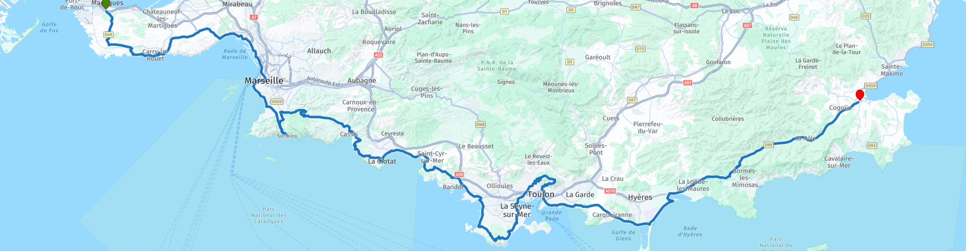
We leave Martigues and drive through Les Calanques, a national park in the Bouches-du-Rhône department. Calanques are narrow, deep inlets in the coast, formed by river erosion and later partially submerged by rising sea levels.
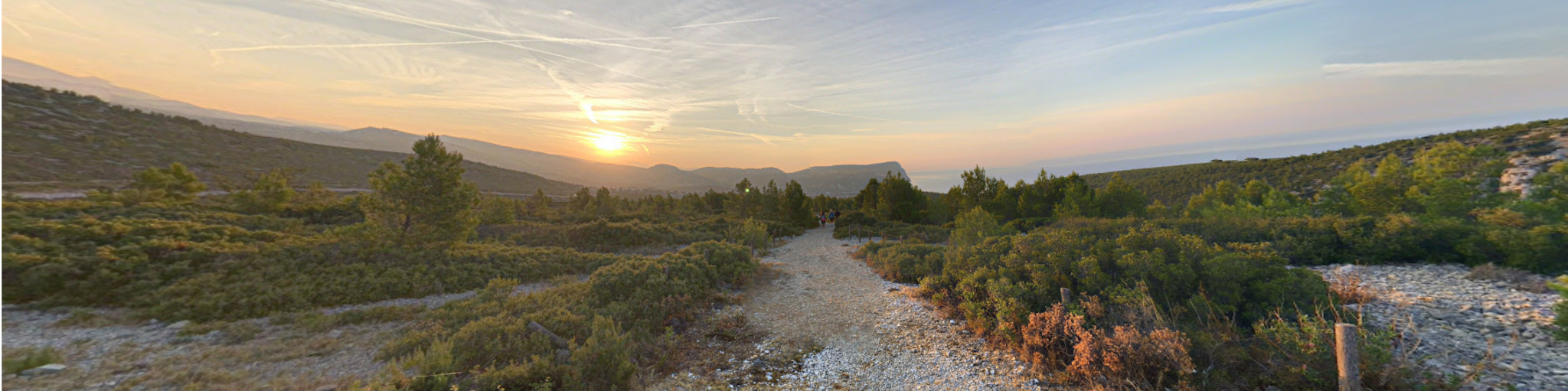
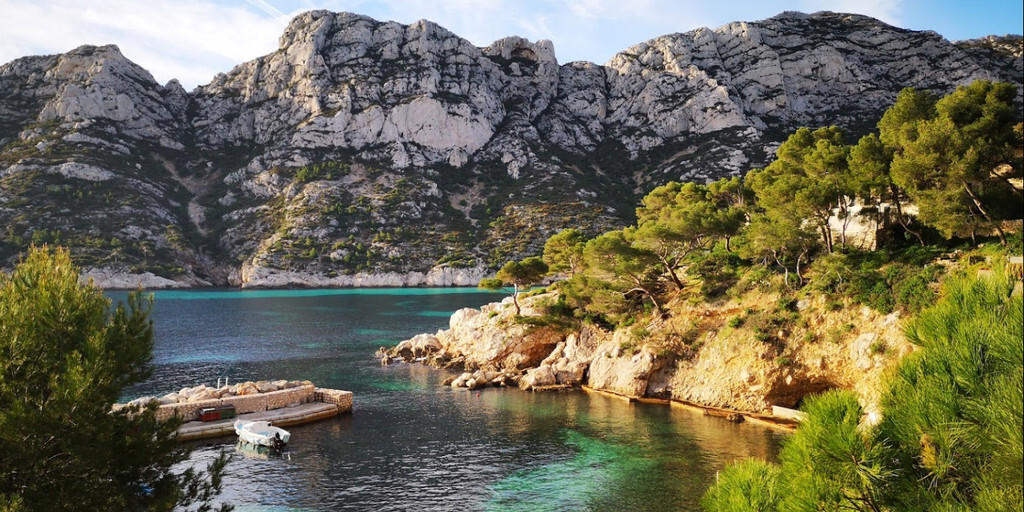
The park is a series of rugged limestone cliffs along the Côte d'Azur, with steep cliffs, few sheltered beaches, and water a beautiful turquoise color. It's a heavenly image.
The park covers a strip of land approximately 20 kilometers long and 4 kilometers wide along the south coast between Marseille and Cassis. Calanque Sormiou, Morgiou, d'En-Vau, Port-Pin, and Sugiton are the names of places along this route.
Our first stop is Calanque de Sormiou, the largest and most famous calanque near Marseille. It's also one of the few inhabited calanques: several fishermen's houses and two restaurants surround the small sandy beach. A walking path runs along the cliffs above, offering breathtaking views. To the left of the Calanque de Sormiou lies the Cosquer Cave, home to prehistoric murals.
The other Calanques are more difficult to reach, but for enthusiasts, they're definitely worth a stop and a hike to enjoy the truly stunning panoramas. The waters of the Côte d'Azur don't get any bluer than in these famous creeks! The high white cliffs also offer impressive sea views. All Calanques are listed as points of interest (POIs).
We'll drive back a bit and then continue our journey via the beautiful Col de la Gineste, a stunning road through beautiful surroundings. There are several parking areas where you can stop for a photo and perhaps a short walk (climb) for an even more stunning view.
We continue along the coast via Cassis to Le Ciotat, again offering beautiful panoramas. In Le Ciotat, we'll stop for lunch and perhaps a refreshing dip in the blue sea at one of the beautiful beaches.
The journey continues along the coast with stunning views of the Mediterranean Sea to the Fôret de Six Fours, a beautiful forest where we'll take a narrow, winding road to Toulon. Just outside Toulon lies Mont Faron, a mountain overlooking the city and the harbour. At its highest point (584m), you can visit the Monument to the Landing and Liberation of Provence, better known as the Mont-Faron Monument.
The Mont-Faron Monument commemorates the Allied landings of August 15, 1944, and the liberation of Provence: Operation Anvil-Dragoon, which allowed the Allies to seize control of the ports of Toulon and Marseille, liberate the Rhône axis, and thus accelerate the liberation of the area and their advance toward Germany. The monument was renovated and reopened to the public in April 2017.
The road to and from the top is narrow but wonderful winding roads with beautiful hairpin bends.
Mont Faron also boasts a cable car unique in the South of France. It allows residents of Toulon and numerous tourists to travel from the foot of the mountain to the summit, approximately 584 meters high: Mont Faron.
The original route ends in Toulon; there are several hotels in the city center and campsites just outside the city. I've adjusted it, and we're driving on to the town of Cogolin.
The route continues along the Côte d'Azur, and for the final 31 km of the journey to Cogolin, you have two options at the roundabout just before the town of Maudroume: turn left onto the D89 through the mountains, or continue along the coast on the D559. Both options are shown in the photo of the track. The end point of the journey is Cogolin, near St. Tropez, where we will spend the night at one of the campsites in Grimaud or Cogolin. Grimaud is the starting point for the next route in this series.

 Links
Links  Usage
Usage Want to download this route?
You can download the route for free without MyRoute-app account. To do so, open the route and click 'save as'. Want to edit this route?
No problem, start by opening the route. Follow the tutorial and create your personal MyRoute-app account. After registration, your trial starts automatically.  Disclaimer
Use of this GPS route is at your own expense and risk. The route has been carefully composed and checked by a MyRoute-app accredited RouteXpert for use on TomTom, Garmin and MyRoute-app Navigation.
Changes may nevertheless have occurred due to changed circumstances, road diversions or seasonal closures. We therefore recommend checking each route before use.
Preferably use the route track in your navigation system. More information about the use of MyRoute-app can be found on the website under 'Community' or 'Academy'.