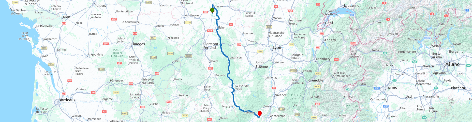
MTG2 05 Moulins Vichy Thiers Aubenas

This route was brought to you by:
RouteXpert René Plücken (MRA Master)
Last edit: 12-02-2021
 Route Summary
 climate. It is not for nothing that you see so many motorcyclists there. My previous series of routes in France were based on the route descriptions from the Motortourgids France part 1 made by Bert Loorbach.
This route comes from Motortourgids France part 2 and the original name is "From Burgundy to the Rhône Valley; Route 1: from Moulins to Aubenas".
In Motorbike guide France part 2 a difference has been made between approach routes and trips in a certain area. The approach routes can also be used in combination with the routes from Motortourgids France part 1
The routes are sometimes slightly adjusted based on the tips that Bert Loorbach gives in his description, or because of a different place to spend the night, or to achieve the minimum length of 2 hours for the MRA Library. For each route there is a more detailed description in the review, including options to stay overnight or places of interest en route, which are also indicated with a POI and if possible with a short description
The route is made suitable for Garmin, TomTom, Harley-Davidson BoomBox 2019 and Navigation App, can be downloaded for free and without My-Route-app registration. To do this, first click on the 'Use route' button and then on 'Save as'.
 Share this route


Animation

Verdict


Duration
6h 29m

Mode of travel
Car or motorcycle

Distance
352.86 km

Countries

 RouteXpert Review
 Three routes are on the west side and one route runs between Clermont-Ferrand and Lyon where you can enjoy the beautiful plateau of the Velay. This is also very suitable if you come from western Burgundy. Then one along St. Étienne and the Col de Ia République, and one that stays reasonably close to Lyon and comes out just below, in Givors. The eastern route is an alternative for those who like to descend on this side as nationally as possible. After some searching I found this route, which leads almost all the way through the green and is even surprisingly nice on some parts.
This first route runs from Moulins to Aubenas and especially the middle part of this route is surprisingly beautiful and you shoot it nicely, not too many difficult turns and an ideal route if you are heading towards Ardèche, Cévennes or Montpellier. The original route mostly consists of N-roads because a approach route must save time, I chose to include the D-roads described here and there in the route, we have vacation and therefore plenty of time.
We leave from Châtel-de-Neuvre, where we spent the night at one of the two campsites (see POI and left) towards Moulins, the original starting point of the route. Moulins is a quiet, medium-sized city on the River Allier, with a beautiful cathedral and the house of Jeanne d'Arc. If you don't want to stop there, it's best to take the ring road. The River Allier runs through Moulins and is sandwiched by two n-roads. the
N7 (east bank) and the N9 (west bank). About both you can go to Vichy. The N9 is a bit greener and the N7 drives a little faster, this is also the original route as described in the Motorbike Guide and starts at RP3, but as said we take the D-roads; D707, D989, D105 and the D32 that connects again with RP6 to the N209, the original route, which runs through the beautiful town of Billy, with a large 12th-century castle (RP8) in the center, which is certainly worth a visit. to visit. The castle is a military fortress built in 1242 and has long been the property of the Bourbon House. The fortified town of Billy was part of the domain of the royal house Bourbon until the French Revolution. Characteristics of the castle are the oval castle wall and the hexagonal watchtower that overlooks the village. The gate of the castle is impressive, as is the view when walking on the southern wall.
We drive via Cusset (RP9) to Vichy (RP10), a well-known seaside resort with a wide range of sporting and cultural events. The city has many cafés and restaurants and is therefore a nice location to stop. At RP10 there are also some shops and at RP11 you are on the banks of the Allier, where there are a number of parks and small beaches. Parking places are indicated with a POI. We leave the city via the bridge over the Allier. At RP13 we leave the original route (D906) again and turn left to drive through beautiful narrow and winding roads through the "Parc Natural Regional Livradois-Forez". At RP16 we enter the beautiful town of Thiers, Thiers is nicely built in the gorge of the river Durolle against the mountain walls. There are still around three hundred smaller or larger knife factories in the city. The city has the shopping districts and hamburger tents. Do you want to score one of the knives, they come in many shapes and sizes and there are really beautiful samples of knife art, then just keep "Center". There is also a museum (two buildings) about the knives: 'Musée de la Coutellerie'.
After Thiers we arrive at the most beautiful part of this tour: straight through the Livradois-Forez regional park.
This concatenation of forests, high plains and rivers is a motorcycle festival. The road is good, with just enough curves to massage the cheeks of your tires from time to time, but also wide, quiet and spacious enough to get along well. The first stretch to the former paper town of Ambert follows the course of the Dore and marks the transition from the mountains of Forez to Livradois.
We continue on to Arlanc, partly on the straight D906 to La chaise-Dieu, which is more than 100 meters high. This place has the magnificent abbey of st. Robert (RP23 Église abbatiale Saint-Robert), founded in the 11th century and built of granite in later centuries.
The drive to Le Puy-en-Velay is a pleasure. You actually stay well above the 80 meter height all the time and this keeps you feeling in the mountains. Pay close attention when coming out of the bends, in this area it can be windy and your motorcycle will sometimes be "sideways".
Arriving in Le Puy-en-Velay (RP25) you can choose to take a break here, this town has something magical about it. It is located in a beautiful environment that invites you to be explored. You can make beautiful walks and enjoy the beautiful nature. Le Puy-en-Velay attracts many hikers because it is one of the most important stopping places on the pilgrim route to Santiago de Compostela in Spain.
We continue on the N88 / N102 to the Parc Naturel Régional des Monts d'Ardèche. Up to about 15 kilometers before Aubenas, the N88 / N102 combination is a beautiful route with many impressive rocks. The last part is a concatenation of turns, so enjoy for every motorcyclist.
To spend the night there are several hotels in Aubenas and a campsite just outside the city in Le Pommier.
I appreciate this route with 4 **** stars because of the beautiful roads, beautiful nature and nice villages and towns along the way. There is enough variation possible to adapt the route to your travel schedule.


 Links
Links  Usage
Usage Want to download this route?
You can download the route for free without MyRoute-app account. To do so, open the route and click 'save as'. Want to edit this route?
No problem, start by opening the route. Follow the tutorial and create your personal MyRoute-app account. After registration, your trial starts automatically.  Disclaimer
Use of this GPS route is at your own expense and risk. The route has been carefully composed and checked by a MyRoute-app accredited RouteXpert for use on TomTom, Garmin and MyRoute-app Navigation.
Changes may nevertheless have occurred due to changed circumstances, road diversions or seasonal closures. We therefore recommend checking each route before use.
Preferably use the route track in your navigation system. More information about the use of MyRoute-app can be found on the website under 'Community' or 'Academy'.