Slovenian Italien mountains round trip Triglav park

This route was brought to you by:
RouteXpert Sandro Linden
Last edit: 10-05-2019
 Route Summary
  Share this route


Animation

Verdict


Duration
3h 4m

Mode of travel
Car or motorcycle

Distance
115.43 km

Countries


 RouteXpert Review
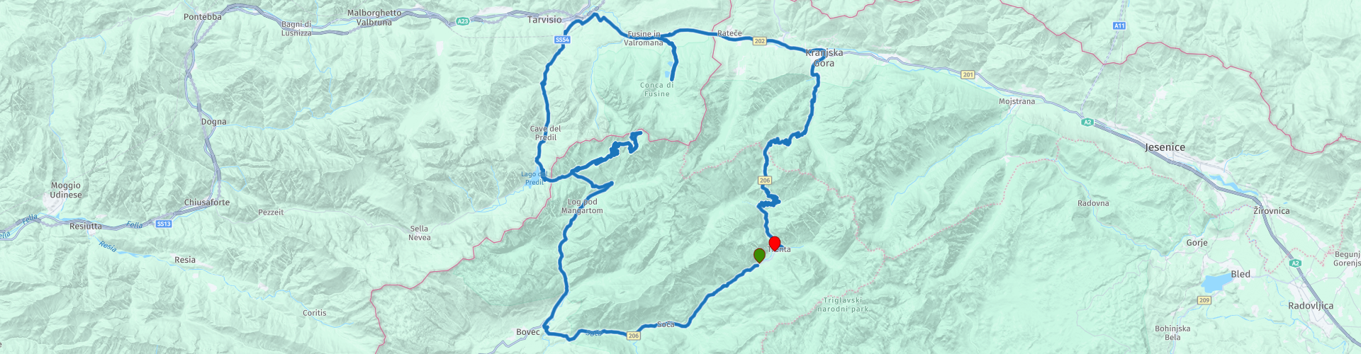
 Just before the town of Bovec we turn right towards the Passo del Predil. Here is also the border crossing to Italy. Before we reach the border, we turn right in the direction of Mangartstrasse. The Mangartstrasse is with 2,055 M the highest road in Slovenia. However, this is not a pass because this is a dead end. As a motorcyclist you pay 5 euros toll to be allowed to drive the road. This is definitely worth it because in my eyes this is the jewel of the Triglav park. At the top of Mangartstrasse you will be treated to an almost 360 degree view.
From here you look at the Italian and Austrian mountain world. This is a very technical road to drive, so not recommended for true beginners.
Once back in the valley, we cross the border in no time to enter Italy via the passo del predil. Here you will quickly come across Predil Lake, which is the ideal place to stop for a good lunch. From the terrace you have a great view over the lake and the surrounding mountains.
The road continues through Italy where we turn right just before the Slovenian border. This road is also a dead end but well worth a look. At the end you come across two mountain lakes where you can also take a break.
From here the route continues towards the Slovenian border. After passing this we arrive in the town of Kranjska Gora. Always nice to walk through. The route continues towards the end point but before we reach this we first come across the Vrsic pass. With its 1,611 M, this is the highest pass in Slovenia but is best known for the 50 hairpin bends, many of which are paved with cobblestones. Look out especially in wet weather! After this pass the end of the route is in sight and you can enjoy a nice ride through a great landscape. You will never forget this!


 Links
Links  Usage
Usage Want to download this route?
You can download the route for free without MyRoute-app account. To do so, open the route and click 'save as'. Want to edit this route?
No problem, start by opening the route. Follow the tutorial and create your personal MyRoute-app account. After registration, your trial starts automatically.  Disclaimer
Use of this GPS route is at your own expense and risk. The route has been carefully composed and checked by a MyRoute-app accredited RouteXpert for use on TomTom, Garmin and MyRoute-app Navigation.
Changes may nevertheless have occurred due to changed circumstances, road diversions or seasonal closures. We therefore recommend checking each route before use.
Preferably use the route track in your navigation system. More information about the use of MyRoute-app can be found on the website under 'Community' or 'Academy'.