Roundtrip Las Vegas Lake Mead Hoover Dam Grand Canyon West

This route was brought to you by:
RouteXpert René Plücken (MRA Master)
Last edit: 19-08-2025
 Route Summary
 Grand Canyon West is not only a world wonder, but also a tourist destination owned and operated by the Hualapai Tribe.
I drove this route in 2017, during our holiday in the USA.
The route is easy to drive with a motorcycle or car. There are no challenging passes or bends and you drive largely on the highway through the Mojave Desert.
The views along the way are beautiful and the sights, especially the Grand Canyon, give this tour 5 stars.
 Share this route


Animation

Verdict


Duration
11h 20m

Mode of travel
Car or motorcycle

Distance
442.81 km

Countries

 RouteXpert Review
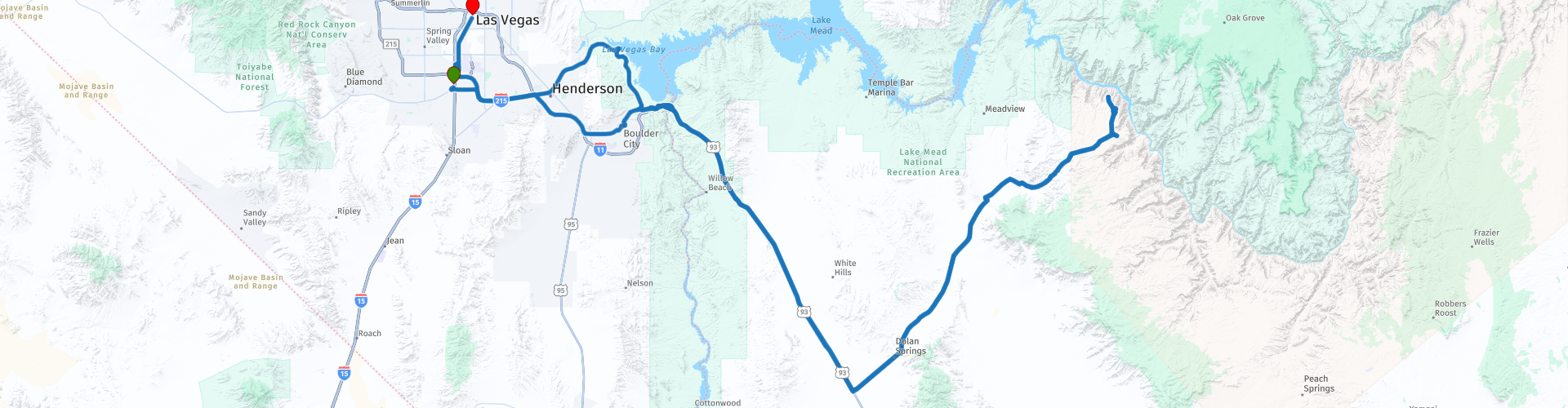
 The route starts at Eaglerider in Las Vegas, make sure you drink enough, preferably with electrolytes (e.g. Gatorade and Powerade), you can buy these at every supermarket and gas station. You drive through the desert and lose a lot of fluid.
We drive towards Henderson where we leave the hustle and bustle of the city and drive to Lake Mead. Here are several parking lots with a nice view of the reservoir. At these parking lots are picnic tables and sometimes also toilets.
We drive over the Hoover Dam (mind the pedestrians) to the parking lot with a nice view over this impressive concrete colossus. We drive back over the dam via the same road. At the Hoover Dam is a visitors center where you can watch a film about the history of this dam, they also provide guided tours. Tickets cost between $10 and $30, depending on the tour you choose.
We take the US -93 through the Mojave desert Doolan Spring, here we also leave the Highway. Doolan Spring is a small village on Highway 25 (Pierce Ferry Road), you can stop here for something to eat and drink.
We drive on Highway 25 towards Meadview, on both sides of this road you see desert mountains and Joshua trees. Just before Meadview we turn right to take Highway 261, at this intersection you can stop well at the large parking lot to take a few pictures of the Joshua Trees and possibly take a walk between the Joshua Trees.
Highway 262 (Diamond Bar Road) is a beautiful winding road through Grapevine Canyon, enjoy the drive to Grand Canyon West where we will visit a number of sights. There are several parking areas along the route where you can stop to take some pictures.
The Grand Canyon West Rim is an emerging tourist destination. 1 million visitors visit the West Rim annually. There are multiple admission tickets available for purchase, ranging in price from $68 to $429.
The West Rim is not only a world wonder, but also a tourist destination owned and operated by the Hualapai Tribe.
Hualapai, meaning "People of the Tall Pines," had an ancestral homeland of about 2 million acres. In 1883, the Hualapai Reservation was established on one million acres of Hualapai ancestral lands in the southern portion of the Colorado Plateau and the Grand Wash Cliffs.
Visitors to Grand Canyon West will gain a glimpse into the traditions that support a dynamic cultural identity manifest within the Hualapai people and their spiritual connection to their land.
Depending on the ticket you buy, you can access the reserve, walk the glass Skywalk at Eagle Point with great views in front of and below you (not recommended for people with a fear of heights), have lunch, raft, spend the night and even fly over and through the Canyon in a helicopter. And definitely hike to Guano Point, this mountain top offers one of the most spectacular viewpoints of the Grand Canyon with the "Highpoint Hike" and a breathtaking 360-degree view of the Canyon. You can climb to the top of the rocks for a breathtaking view. There is an abandoned cable car that was built to extract guano from the mine. Guano, or bat droppings, was a popular ingredient in fertilizer, dynamite and even make-up at the time.
The return journey is via the same route with the difference that we visit Boulder City to eat in one of the many good restaurants. From Boulder City we drive back to Las Vegas, where we drive over the famous strip to Fremont Street. You can marvel at the Hotel-Casinos along the strip and make a stop at the famous Bellagio to see the fountain spraying to music and light show. The end point is Fremont Street in old Las Vegas, where you can visit the famous casinos such as the Golden Nugget and 4 Queens. There is a lot to do on Fremont Street, there is a Zip-Line, live music, bars, restaurants and of course hotels to stay overnight.


 Links
Links  Usage
Usage Want to download this route?
You can download the route for free without MyRoute-app account. To do so, open the route and click 'save as'. Want to edit this route?
No problem, start by opening the route. Follow the tutorial and create your personal MyRoute-app account. After registration, your trial starts automatically.  Disclaimer
Use of this GPS route is at your own expense and risk. The route has been carefully composed and checked by a MyRoute-app accredited RouteXpert for use on TomTom, Garmin and MyRoute-app Navigation.
Changes may nevertheless have occurred due to changed circumstances, road diversions or seasonal closures. We therefore recommend checking each route before use.
Preferably use the route track in your navigation system. More information about the use of MyRoute-app can be found on the website under 'Community' or 'Academy'.
.jpg/800px-Grand_Canyon_Horseshoe_Bend_(crop_2).jpg)
Arizona
About this region
Arizona (AIR-iz-OH-nə; Navajo: Hoozdo Hahoodzo Navajo pronunciation: [hoː˥z̥to˩ ha˩hoː˩tso˩]; O'odham: Alĭ ṣonak) is a state in the Western United States, grouped in the Southwestern and occasionally Mountain subregions. It is the 6th largest and the 14th most populous of the 50 states. Its capital and largest city is Phoenix. Arizona shares the Four Corners region with Utah to the north, Colorado to the northeast, and New Mexico to the east; its other neighboring states are Nevada and California to the west and the Mexican states of Sonora and Baja California to the south and southwest.
Arizona is the 48th state and last of the contiguous states to be admitted to the Union, achieving statehood on February 14, 1912. Historically part of the territory of Alta California in New Spain, it became part of independent Mexico in 1821. After being defeated in the Mexican–American War, Mexico ceded much of this territory to the United States in 1848. The southernmost portion of the state was acquired in 1853 through the Gadsden Purchase.
Southern Arizona is known for its desert climate, with very hot summers and mild winters. Northern Arizona features forests of pine, Douglas fir, and spruce trees; the Colorado Plateau; mountain ranges (such as the San Francisco Mountains); as well as large, deep canyons, with much more moderate summer temperatures and significant winter snowfalls. There are ski resorts in the areas of Flagstaff, Alpine, and Tucson. In addition to the internationally known Grand Canyon National Park, which is one of the world's seven natural wonders, there are several national forests, national parks, and national monuments.
Since the 1950s, Arizona's population and economy have grown dramatically because of migration into the state, and now the state is a major hub of the Sun Belt. Cities such as Phoenix and Tucson have developed large, sprawling suburban areas. Many large companies, such as PetSmart and Circle K, have headquarters in the state, and Arizona is home to major universities, including the University of Arizona and Arizona State University. Traditionally, the state is politically known for national conservative figures such as Barry Goldwater and John McCain, though it voted Democratic in the 1996 presidential race and in the 2020 presidential and senatorial elections.
Arizona is home to a diverse population. About one-quarter of the state is made up of Indian reservations that serve as the home of 27 federally recognized Native American tribes, including the Navajo Nation, the largest in the state and the United States, with more than 300,000 citizens. Since the 1980s, the proportion of Hispanics in the state's population has grown significantly owing to migration from Mexico. In terms of religion, a substantial portion of the population are followers of the Catholic Church and The Church of Jesus Christ of Latter-day Saints (Mormon).
Read more on Wikipedia
Arizona is the 48th state and last of the contiguous states to be admitted to the Union, achieving statehood on February 14, 1912. Historically part of the territory of Alta California in New Spain, it became part of independent Mexico in 1821. After being defeated in the Mexican–American War, Mexico ceded much of this territory to the United States in 1848. The southernmost portion of the state was acquired in 1853 through the Gadsden Purchase.
Southern Arizona is known for its desert climate, with very hot summers and mild winters. Northern Arizona features forests of pine, Douglas fir, and spruce trees; the Colorado Plateau; mountain ranges (such as the San Francisco Mountains); as well as large, deep canyons, with much more moderate summer temperatures and significant winter snowfalls. There are ski resorts in the areas of Flagstaff, Alpine, and Tucson. In addition to the internationally known Grand Canyon National Park, which is one of the world's seven natural wonders, there are several national forests, national parks, and national monuments.
Since the 1950s, Arizona's population and economy have grown dramatically because of migration into the state, and now the state is a major hub of the Sun Belt. Cities such as Phoenix and Tucson have developed large, sprawling suburban areas. Many large companies, such as PetSmart and Circle K, have headquarters in the state, and Arizona is home to major universities, including the University of Arizona and Arizona State University. Traditionally, the state is politically known for national conservative figures such as Barry Goldwater and John McCain, though it voted Democratic in the 1996 presidential race and in the 2020 presidential and senatorial elections.
Arizona is home to a diverse population. About one-quarter of the state is made up of Indian reservations that serve as the home of 27 federally recognized Native American tribes, including the Navajo Nation, the largest in the state and the United States, with more than 300,000 citizens. Since the 1980s, the proportion of Hispanics in the state's population has grown significantly owing to migration from Mexico. In terms of religion, a substantial portion of the population are followers of the Catholic Church and The Church of Jesus Christ of Latter-day Saints (Mormon).
View region
 Statistics
  26
26Amount of RX reviews (Arizona)
 30470
30470Amount of visitors (Arizona)
 556
556Amount of downloads (Arizona)
 Route Collections in this region
 Car or motorcycle tour through the western US
This collection contains all 15 routes driven by MRA Goldmember André ter Schegget during his three-week tour through the west of America.
The places to visit, the attractions and beautiful photo spots are nicely marked on the routes. The routes have been fully checked and made equal for the Garmin and the TomTom. Enjoy this wonderful trip and let us know how it was! Enjoy and stay safe!
Order of the tour:
Route 01: from Los Angeles and via Pacific Coast Highway to Solvang
Route 02: Solvang to Monterey / Pacific Grove
Route 03A: Monterey to San Francisco
Route 03B: if you are by car instead of the motorcycle, as motorcycles are not allowed on the 17 Mile Drive: from Monterey to the 17 Mile Drive and further to San Francisco
Route 04: from San Francisco via Nappa and Eldorado National Forrest to Topaz Lake
Route 05: from Topaz Lake via Bodie and Yosemite to Oakhurst
Route 06: from Oakhurst via Kings Canyon NP and Sequoia NP and Giant Forest to Exeter
Route 07: Exeter via Isabella Lake and Ridgecrest to Death Valley
Route 08: from Death Valley via Valley Of Fire to Mesquite
Route 09: from Mesquite via Zion NP and Dixie NF to Hatch
Route 10: Hatch via Bryce Canyon to Page
Route 11: from Page via Grand Canyon to Williams
Route 12: from Williams via Seligman and Route 66 to Kingman and via Hoover Dam to Las Vegas
Route 13: from Las Vegas via Oatman and Lake Havasu to Parker
Route 14: from Parker via Joshua Tree to Rancho Mirage
Route 15: Rancho Mirage via Palm Springs to Santa Monica
View Route Collection
Top car and motorcycle tour through the west of the USA
By car or motorcycle through the West of America is a journey that you do not just make, so also not driving 15 days and then back home. No, book a stay of several days in Los Angeles, Las Vegas, San Francisco and again Los Angeles to also visit several places of interest in these cities, so that this tour becomes an unforgettable tour that you can remember with pleasure.
Do not forget to arrange and pack the following items:
*This is only a summary and completely personal and may differ per person.
Take out travel insurance, +31 for numbers in GSM, (partially) take out gas, Health insurance coverage at destination?, Switch off electrical appliances, Lighting (time clock), Check passport validity, Antenna from radio/TV due to lightning, Residence address for those left behind, Remote control house alarm, Book Smart Parking.
Hand luggage:
Liquids in packaging of max. 100 ml, Liquids in hand luggage in transparent plastic bag.
For on the road:
Candy, Book, Earplugs, Country and road map(s), Directions, Maps in your navigation system
Money & Securities:
Bank card / giro card, Credit card (think pin code), Cash, Calculator for Internet banking, Medical insurance card, Travel insurance card.
Travel documents:
Passport, (International) Driver's License, Ticket(s), Reservation Tickets, Hotel Vouchers, Arrival/Departure Time, Check-in & Check-out Times, Valid Visa (ESTA), Travel Guide.
Clothing:
Underwear, Belt, Shirts/ T-shirts, Shorts, Long pants, Shoes, Socks, Swim trunks, Towel, Slippers.
Personal stuff:
Watch, House Keys, Wallet, Sunglasses.
Toiletries:
Deodorant, Shower gel / Soap, Comb / brush, Shaving equipment, Shampoo, Toothbrush, Toothpaste, Sanitary pads
Health & Medicine:
Own medicines, Insect repellent, Cold sore ointment, Ointment for insect bites, Sunscreen, Norit, Paracetamol, Suction cup for insect bites, First aid bag.
Miscellaneous:
Travel bag / waist bag, Leatherman (= checked luggage), Pen or pencil, Headlamp, Lighter, Tools & Electronics, Mobile phone & charger, Photo/video camera & charger, Memory card(s), World plug / adapter, Ipod & charger, Adapter cable Ipod, Headphones, iPad & charger, Navigation & charger/plug, Plug socket, Fuelpack battery.
Engine (accessories):
Helmet, Motorcycle clothing, Motorcycle boots, Chain lock / disc brake lock, Gloves, Bandana, Inner bags (plastic shopping bag), Insulation bag, Tension straps, Tie wraps, Rain suit, Rainaway.
Addresses:
Address list, Embassy telephone number, Telephone number to block (bank) card(s), Telephone number (airline tickets).
View Route Collection