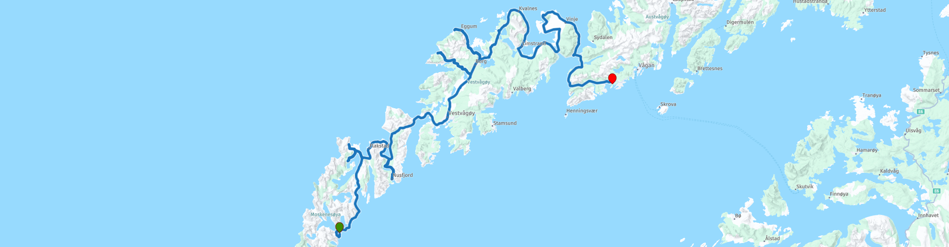
Day 07 North Cape Tour Lofoten Reine Orsvagvaer

This route was brought to you by:
RouteXpert René Plücken (MRA Master)
Last edit: 11-04-2021
 Route Summary
 The Lofoten consists of a number of islands. The most famous are: Røst Værøy Gimsøya Moskenesøya Vestvågøy Austvågøy Flakstadøya Some places in Lofoten are Svolvær, Leknes, Vågan, Ramberg, Moskenes and Reine.
You drive longer distances in Norway without encountering a gas station or restaurant, keep this in mind before you drive. Make sure your tank is full and bring food and drinks. Bring a few bottles of water or Camel bag and fill it up when you stop to refuel. A number of breaks are scheduled along the way for refueling, eating and drinking.
You have the choice to stay overnight at campsites or in hotels. Hotel prices in Norway are not particularly high and breakfast is usually included. Camping is free almost everywhere, except on private property or where camping is prohibited, indicated by prohibition signs. If you don't want to camp, there are often cabins for rent on the campsites. For a trip through Norway it is always advisable to bring a tent and other camping gear.
I rate this route with 5 **** stars because of the beautiful roads, beautiful nature and some beautiful places to stop. This route can also be divided into several days in order to enjoy all the beauty of the Lofoten even more.
 Share this route


Animation

Verdict


Duration
10h 48m

Mode of travel
Car or motorcycle

Distance
218.11 km

Countries

 RouteXpert Review
 We depart from Reine on the island of Moskenesøya and drive to the island of Flakstadøya which we reach via De Kåkern bridge (RP9), a concrete box girder with a total length of 303 meters and a main span of 171.5 meters. The bridge has a slightly narrowed carriageway, without two marked lanes, but passing it is not problematic. The bridge spans the Kåkersundet, a narrow strait between the islands of Flakstadøya and Moskenesøya. The bridge is free
At RP10 you can deviate from the route if you like hiking. Turn left to hike one or two scenic trails. Please note that they take a lot of time, so an extra night is recommended. At RP11 you can go straight to the “Hike to Fuglhuken” (RP13) or you can turn left to the “Hike to Kvalvika Beach” (RP14). A brief description of both follows below. At RP12 you still have the option to turn left and visit the Lofoten Turf Museum (Torvmuseet), here you will get an idea of the history of peat production and life along the coast in times gone by. The basic idea behind the museum is to create a farmyard where the focus is on peat extraction and the lives and circumstances of those involved. Peat extraction is an important part of Lofoten's cultural heritage.
RP13 Hike to Fuglhuken; This beautiful walk allows you to explore the northernmost point of Moskenesoya Island, through wild, varied landscapes. From the top of the Litlberget Ridge, which overlooks the Stokkvikdalen Valley, you can think of the few families who lived there in total isolation until the end of the nineteenth century. From this recent past there are now only a few foundations scattered around and peat meadows enclosed by low stone walls. The beautiful Fuglhuken summit towers over the valley like a shield with a view of the Norwegian sea and the beautiful Fredvang Strand
RP14 Kvalvika Hike and Strand; this walk takes you to Kvalvika beach, one of the most popular in all of Lofoten. The beautiful beach can only be reached on foot and the sight of the beach between the mountains is a feast for the eyes. Kvalvika Beach is also a popular spot for camping, offering extra time to enjoy the magic of the site after the day hikers have left. Combine the trip to Kvalvika with a hike to Ryten for more famous views of the sandy beach below.
We continue to Nusfjord (RP19), one of the oldest and best preserved fishing villages in Norway. It is located on the Lofoten archipelago and administratively belongs to the municipality of Flakstad. Nusfjord was designated by UNESCO in 1975 as a pilot project to preserve traditional Norwegian architecture and well worth a visit. Archaeological excavations have uncovered settlements from the 5th century. It was one of the first places where cod was processed on an industrial scale in the Nordland region. There are 2 historic power stations and about fifty buildings.
Nusfjord is currently no longer inhabited permanently and is a museum village. However, it is still possible to spend the night in a traditional rorbuer. There are also restaurants and cafes.
Via the beautiful Fv807 we drive to Nappsholmen where we drive via Nappstraumtunnel (RP20), a submarine road tunnel of 1,776 meters long from Flakstadøya to Vestvågøya. The tunnel was opened on July 11, 1990 to replace an old ferry connection between the two islands. The tunnel reaches a depth of 63 meters below sea level and the maximum slope of the tunnel is 8%. On the island of Vestvågøya there are several beautiful locations where you can stop to admire the beautiful nature, a number of them are indicated with Waypoints.
Be sure to visit the Lofotr Viking Museum (RP22), a historical museum based on a reconstruction and archaeological excavation of a Viking chief's village on the island of Vestvågøya. Today the area has been excavated and new buildings have been added. This part of the museum includes two permanent exhibition halls and a movie theater. Videos are shown in the exhibition rooms and unique artifacts about Borg's find and excavation can be seen. Quite a number of the archaeological artifacts are of remarkable character. The expansive outdoor space of the museum is linked by gravel walking paths, which invite visitors to explore the history in greater content than just the exhibition halls, such as the reconstructed Chieftain's house atop the hill or to board the Viking ship. going, the surrounding panoramas of the landscape and everything it offered in the Viking age all add to the experience.
We drive on to the coast at Eggumsveien (RP24) where you can take beautiful pictures. Please note at RP23 and RP27 that you keep following the provincial road Fv831, TomTom and Here take a different route here.
At RP34 you can stop at Dan Graham's glass construction. This sculpture with its transparent, reflective walls is placed next to the main road and does not appear to be present primarily as something material, but rather as something that captures the light and image of the surrounding landscape. With its reflective, hollow panorama wall, it creates a feast for the eyes. At the same time, we see a landscape that could occur in any painting that has the sublime landscape as its theme, but that is both present and depicted at this unique moment.
After this last short stop it is another 15km drive to our Ørsvågvær, where you can stay in a unit with kitchenette at the Tourist Center “Lofoten Turist og Rorbusenter” or camp at the campsite “Sandvika Fjord og Sjøhuscamping”.


 Links
Links  Usage
Usage Want to download this route?
You can download the route for free without MyRoute-app account. To do so, open the route and click 'save as'. Want to edit this route?
No problem, start by opening the route. Follow the tutorial and create your personal MyRoute-app account. After registration, your trial starts automatically.  Disclaimer
Use of this GPS route is at your own expense and risk. The route has been carefully composed and checked by a MyRoute-app accredited RouteXpert for use on TomTom, Garmin and MyRoute-app Navigation.
Changes may nevertheless have occurred due to changed circumstances, road diversions or seasonal closures. We therefore recommend checking each route before use.
Preferably use the route track in your navigation system. More information about the use of MyRoute-app can be found on the website under 'Community' or 'Academy'.