Day 02 North Cape Tour Geiranger Kristiansund

This route was brought to you by:
RouteXpert René Plücken (MRA Master)
Last edit: 18-12-2025
 Route Summary
 You drive longer distances in Norway without encountering a gas station or restaurant, keep this in mind before you drive. Make sure your tank is full and bring food and drinks. Bring a few bottles of water or Camel bag and fill it up when you stop to refuel. A number of breaks have been planned along the way for refueling, eating and drinking.
You have the choice to spend the night at campsites or in hotels. Hotel prices in Norway are not particularly high and breakfast is usually included. Camping is free almost everywhere, except on private property or where camping is prohibited, indicated by prohibition signs. If you don't want to camp, there are often cabins for rent on the campsites. For a trip through Norway it is always advisable to bring a tent and other camping gear.
I rate this route with 5 **** Stars because of the breathtaking fjords, beautiful roads and beautiful panoramas along the way. This ride is a must for any motorcyclist.
 Share this route


Animation

Verdict


Duration
7h 45m

Mode of travel
Car or motorcycle

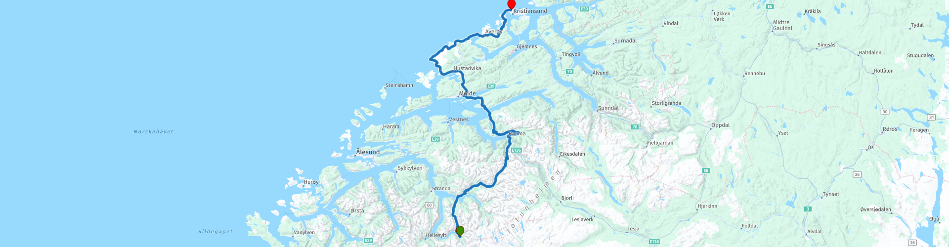
Distance
239.11 km

Countries

 RouteXpert Review
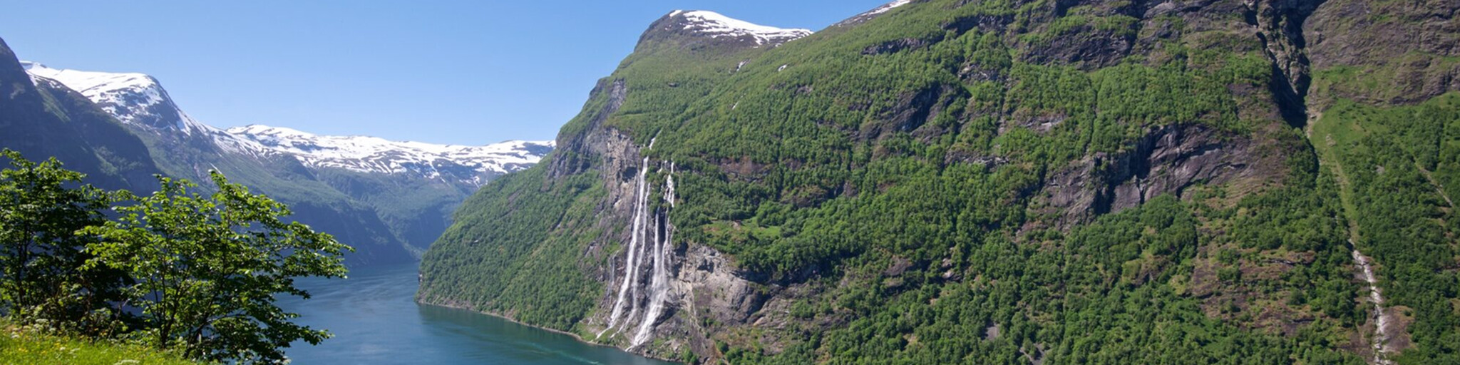
 After about 3 kilometers, you'll reach the top via a wonderfully winding road with beautiful hairpin bends. The panoramic view is stunning, but keep your eyes on the road; the road is very narrow and can be busy, especially with campervans. After about 4 kilometers, you'll arrive at the Ørnesvingen Viewpoint, where we'll stop to enjoy the magnificent Geirangerfjord. The view here is truly phenomenal in good weather.
After the last bend, we enter the Geiranger-Herdalen Landscape Protection Area. This area has been protected by Royal Decree since October 8, 2004. The area covers approximately 498 km² in the municipalities of Stranda and Norddal on Sunnmøre. The purpose of the protection is threefold:
1. Create a characteristic and beautiful fjord and mountain landscape with rich and varied plant and animal life.
2. Maintain important cultural landscapes where fjord farms, meadows, and cultural monuments form an important part of the unique character of the landscape.
3. Provide geological deposits and landforms.
The drive through this area is magnificent, thanks to the beautiful panoramas of this valley. Arriving at Eidsdal, we take the ferry to Linge. The ferry departs every 30 minutes, takes about 13 minutes, and costs NOK 112 (approximately €11.00). We continue along the banks of the clear blue Valldøla River to Gudbrandsjuvet.
Gudbrandsjuvet is a 5-meter-narrow and 20-25-meter-high ravine through which the Valldøla River flows. The waters have formed a complex of deep hollows and intricate formations. The depth of the water's surface is approximately equal to the depth of the ravine to the river. You can also enjoy a drink at the Gudbrandsjuvet Café.
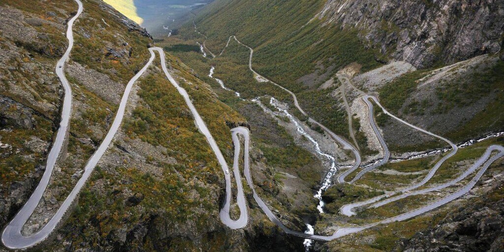
After these short stops, we drive to the next and perhaps the most beautiful highlight of the day: the world-famous Trollstigen!
The Trollstigen is open from May to October. Opening hours depend on weather conditions. This road is one of Norway's most visited attractions and runs along the UNESCO-protected Geirangerfjord. The road has 11 hairpin bends.
But before we descend this road into the Isterdalen valley, we first stop at the modern Trollstigen Café. The new service building houses a café, souvenir shops with local handicrafts, restrooms, parking, beautiful water features, as well as bridges and paths to viewing platforms. World-class architecture in harmony with nature.
Take your time to admire the beautiful winding road down, the surrounding landscape, and the waterfalls. Check out the various viewpoints from which you can take stunning photos. You can also enjoy a drink and/or a bite to eat at the café.
After this break, we'll get back on the bike and begin our descent of the Trollstigen. Drive slowly and enjoy the beautiful surroundings and its waterfalls. Pay close attention to the road, as it's busy. Along the way, there are a few places where you can stop for a photo. And if you have time, drive up and back again.
We drive around the Romsdalsfjorden to Åfarnes, where we take the ferry to Sølsnes. The ferry departs every 40 minutes, takes about 13 minutes, and costs approximately 112 NOK (€11.00). We leave the ferry and drive along the coast, descending to the beautiful Bolsøy Bridge, which takes us to Molde via the small island of Bolsøya.
The Bolsøy Bridge is a concrete girder bridge that crosses the Bolsøysund strait between the mainland and the island of Bolsøya. The Bolsøy Bridge opened in 1991 as part of County Road 64, and together with the Fannefjord Tunnel, it provides a ferry-free connection from the city of Molde and the island of Bolsøya to the village of Nesjestranda on the mainland. The 555-meter-long bridge has 11 spans, the longest of which is 55 meters, and the maximum distance from the sea is 16 meters.
We drive mostly along the coast of the Frænfjorden and Harøyfjorden with beautiful views to Bud, where we stop for fuel.
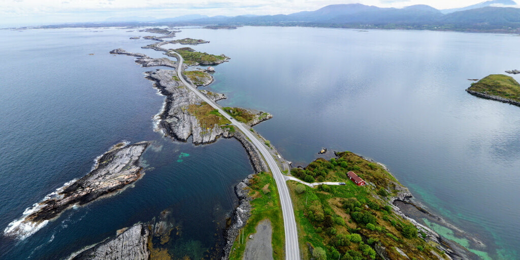
After this, we'll drive to the next highlight of the day: the "Atlanterhavsvegen," or "The Atlantic Road," which, with its eight beautiful bridges, connects the islands of Averøy, Vevang, and Eide to the mainland, Kristiansund, and Molde. Construction began on August 1, 1983, and the road opened on July 7, 1989. The 8.3-kilometer road crosses several islands and the archipelago. Today, it's also a tourist route. There are several parking areas along the route where you can stop to take photos of these beautiful bridges.
Kristiansund is the end point of this beautiful day.
 Links
Links  Usage
Usage Want to download this route?
You can download the route for free without MyRoute-app account. To do so, open the route and click 'save as'. Want to edit this route?
No problem, start by opening the route. Follow the tutorial and create your personal MyRoute-app account. After registration, your trial starts automatically.  Disclaimer
Use of this GPS route is at your own expense and risk. The route has been carefully composed and checked by a MyRoute-app accredited RouteXpert for use on TomTom, Garmin and MyRoute-app Navigation.
Changes may nevertheless have occurred due to changed circumstances, road diversions or seasonal closures. We therefore recommend checking each route before use.
Preferably use the route track in your navigation system. More information about the use of MyRoute-app can be found on the website under 'Community' or 'Academy'.