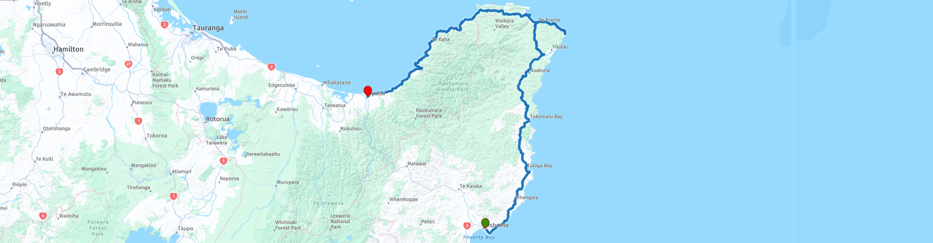
13a Gisborne to Opotiki Coastal route

This route was brought to you by:
RouteXpert Nick Carthew - (MRA Master)
Last edit: 10-02-2021
 Route Summary
 Both routes have incredibly beautiful scenery so the choice is yours.
For those of you who like to collect the country's cardinal points, this route visits East Cape, the easternmost point of the main islands of New Zealand. The west coast road along the shores of the Bay of Plenty is a joy to travel on.
The landscape, coastal vistas and roads are very good with good attractions earn this route 4**** stars.
 Share this route


Animation

Verdict


Duration
8h 30m

Mode of travel
Car or motorcycle

Distance
371.37 km

Countries

 RouteXpert Review
 Remote, windswept and soul-refreshing the East Cape of New Zealand offers the chance to get off the beaten track and exit the rat race. The Pacific Coast Highway (SH 35) is one of the world’s greatest, and least known, coastal road trips. It is single carriageway the whole way, windy and around every corner there will be something new to see. Stunning headlands, remote countryside, empty bays and coves, and bush clad peaks all mix together with remote settlements and farms to make this part of New Zealand the greatest place to replenish. The pace of life on the East Cape will mean you will want to go the same speed – slowly.
At RP 4, you can walk out on the 660 m long pier known as Tolaga Bay Wharf. Extending far into the deep water of Tolaga Bay, this wharf is a legendary place to dangle a fishing line. Allow half an hour to walk to the end of New Zealand's longest wharf and back. The opening of Tolaga Bay Wharf in 1929 made it possible for large coastal trading ships to load and offload goods. However, even as the Tolaga Bay wharf opened, improved roading and motor vehicles had begun to compete with coastal shipping. It was ironic that much of the cargo that passed over the wharf was road-making material, used to construct the road through to Gisborne, soon providing an alternate means of transport.
In recent years the wharf has undergone extensive restoration work, which will help to ensure that locals and travellers can dangle a line for many years to come.
I have suggested a coffee stop at Cafe 35 in the small town of Tokomaru Bay. After your stop, you can go straight on after crossing the river to visit the old Tokomaru Bay Wharf. It's a pleasant ride along the coast with palm trees and ferns along the 3 km road.
The Tokomaru Bay Wharf at Waima, Tokomaru Bay was built in 1940, replacing an earlier structure. The success of the Tokomaru Freezing Works had necessitated the continued expansion of the wharf since 1911; however, the disestablishment of the Tokomaru Bay Freezing Works in 1952 meant that the wharf was no longer utilised to any great capacity. Tokomaru Bay Wharf has historical and social significance as a recognisable remnant of a once thriving industry in Waima.
Back onto the Pacific Coast Highway and enjoy the next 80 kms of undulating & twisty road as you head north to Te Araroa. I have suggested re-fuelling for both human and machine here. The fuel pumps only operate with a card and the Kai Kart Cafe has great reviews on TripAdvisor.
Te Araroa is also the gateway to the historic East Cape Lighthouse – the most easterly point on mainland New Zealand and the first place to see the sunrise in the world each day. The breathtaking views are definitely worth the 700 steps up to the lighthouse! The road to the lighthouse is 20 kms long and half of it is on a narrow gravel road, the last 2 kms are on an elevated section around the cliffs with no protection, caution is required. Skip RP 13 if you don't want to ride the 40 kms.
RP 14 in Te Araroa is where you'll find the oldest and largest pohutukawa tree in the world at the local school grounds. Known as Te Waha-o-Rerekohu (the mouth of Rerekohu) is over 600 years old, it had a branch span of more than 37 metres when measured in 1950. The signage which explains the origin of the name is aptly displayed next to a model pātaka — an elevated food storehouse. Whilst the pātaka is of recent vintage — it was made by local residents — its symbolism harps back to the day when the tree was used as a whata-kai (a food drop-off centre), a practice reserved for people of high rank.
The next few kilometres are at sea level and relatively straight, you'll then climb high up to RP 16 where you'll have a great view across beautiful Hicks Bay. The area is named after Zachary Hicks, second-in-command of James Cook's Endeavour, which sailed along the East Cape on 31 October 1769.
The route is heading in a westerly direction now as you travel across the top of the Raukumara Peninsula towards it's west coast. The Pacific Coast Highway hugs the shoreline of the west coast with sea views of the Bay of Plenty around every corner. The name 'Bay of Plenty' was bestowed by Captain James Cook in 1769 when he noticed the abundant food supplies at several Maori villages there, in stark contrast to observations he had made earlier in Poverty Bay.
The 75 kms along the shores of the Bay of Plenty from Cape Runway RP 18 to the end of the route at Opotiki is a superb ride with an exciting twisty road and breathtaking coastal vistas.
Opotiki is a small town whose Maori population exceeds 50%, making it one of the few towns in New Zealand to be predominantly populated by Maori. Reflecting the area’s importance for Maori the main street in Opotiki is decorated with the works of master carvers. To get a picture of local history, you can take a guided walk with a Maori historian or visit the museum. Opotiki was one of the first places settled by Maori; it was also a centre for the Hauhau religion. In summer, the town fills up with holiday makers who come to enjoy the surf beaches, fishing and river activities.
The route ends, after filling up with fuel for tomorrow, at the Ranui Motel. As Opotiki is favoured by visitors, there are many choices for accommodation, I have included a few below.
Enjoy.


 Links
Links  Usage
Usage Want to download this route?
You can download the route for free without MyRoute-app account. To do so, open the route and click 'save as'. Want to edit this route?
No problem, start by opening the route. Follow the tutorial and create your personal MyRoute-app account. After registration, your trial starts automatically.  Disclaimer
Use of this GPS route is at your own expense and risk. The route has been carefully composed and checked by a MyRoute-app accredited RouteXpert for use on TomTom, Garmin and MyRoute-app Navigation.
Changes may nevertheless have occurred due to changed circumstances, road diversions or seasonal closures. We therefore recommend checking each route before use.
Preferably use the route track in your navigation system. More information about the use of MyRoute-app can be found on the website under 'Community' or 'Academy'.