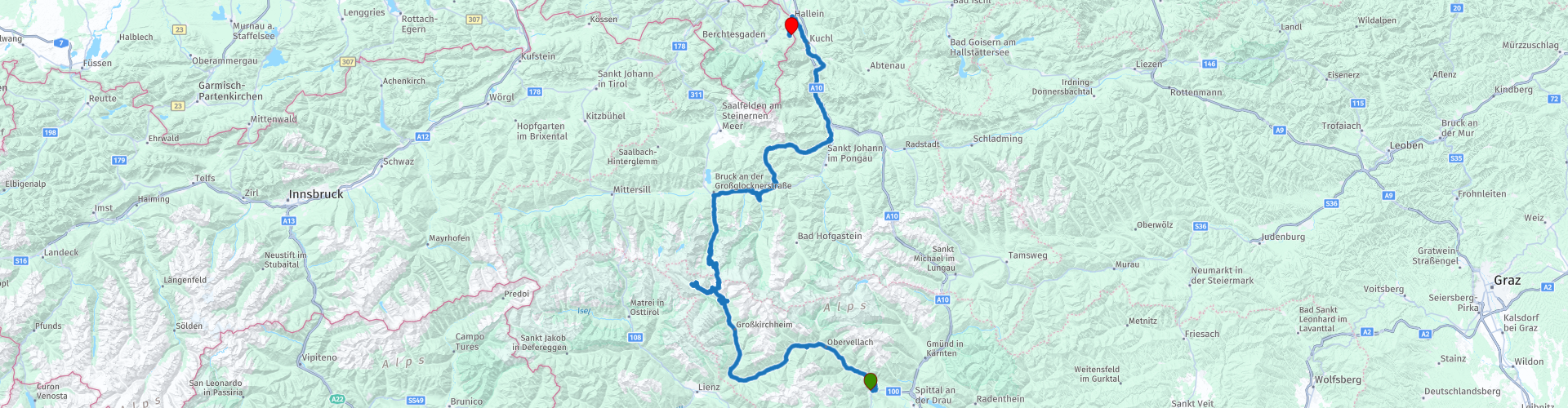
15 From Sachsenburg to Berchtesgaden via Grossglockner mountain pass

This route was brought to you by:
RouteXpert Leonor Orban - Sr. RouteXpert
Last edit: 11-04-2021
 Route Summary
 With a little detour over wonderful Alpine passes you continue your way to Germany today. Take the time to enjoy everything you encounter along the way. On the Großglockner High Alpine Road, via the Kaiser-Franz-Josefs-Höhe you can admire the (retreating) Pasterze glacier as well as the highest accessible point: the Edelweißspitze.
Once you have said goodbye to this alpine street, you drive over the Dientner Sattel towards Bischofshofen and Salzburg. Why take the main road, when you can also drive a modest mountain pass?
Eventually you cross the border at Hallein to Germany, Berchtesgaden. At the foot of the Roßfeld Panoramastraße you settle down at a wonderful mountain hotel, where you can catch up on everything you have seen and done today. Not only impressive mountain passes are on the menu, but also a number of beautiful sights. Think of the Raggaschlucht, Jungfernsprung, Burg Hohenwerfen, Salzachklamm and of course "the Sound of Music".
 Share this route


Animation

Verdict


Duration
6h 38m

Mode of travel
Car or motorcycle

Distance
247.90 km

Countries

 RouteXpert Review
 Today you say goodbye to Austria. We make it a special goodbye. The Großglockner High Alpine Road is on the "to-do list"! Many motorcyclists have stuck the famous Großglockner sticker somewhere on his or her motorcycle. You get this when you purchase a ticket to conquer the Großglockner. At the end of the morning, you can also attach it to your motorcycle (or one of your suitcases).
Despite the fact that your MRA or other type of navigation is very likely to navigate fine, you can also use the landscape as a navigation method during this route. Pretty soon, after leaving the hotel in Sachsenburg, you cross the Möll (rp 3). This river originates at an altitude of about 2400m in the Hohe Tauern National Park. The Pasterze glacier feeds this mountain stream (in Celtic “Molina”… hence the name Möll) and further towards the valley the river increases in strength and you will regularly see people kayaking or rafting on the river because of this wild water.
You follow the river upstream to Flattach. Here is one of the first sights along the route: the Raggaschlucht (rp 4). The roughly 800 meters long and narrow gorge was created because the water of the Ragga brook has, over a period of thousands of years, carved its way through the rocks. Since the end of the 19th century, the gorge has been made accessible to pedestrians. Even nowadays you can only walk through the gorge on the wooden stairs and railings. The water from the brook still rushes through the gorge, making it an overwhelming walk. The steep cliffs and narrow passages certainly contribute to this overwhelming feeling. Keep in mind that the walk takes about an hour.
After this cooling hike (it is on average 10 degrees cooler in the gorge than outside the gorge) you continue the road along the Möll towards the Großglockner. As you drive down the B107 your eye will most likely catch something glittering in the distance. It remains there and the closer you get, the more it becomes clear that it is an immense waterfall. The Jungfernsprung can be seen from afar. To prevent your attention from straying too far from driving, you can stop on the way at a nearby parking lot (rp 5). From the wooden platform you can take magnificent photos of the 130m high waterfall.
You will also have noticed that the beginning of the Großglockner High Alpine Road cannot be too far away. The climb towards the Hohe Tauern has started slowly and you pass a number of places that signal that you are on the right path. Thus, the "Haus der Steinböcke" (rp 6) is a clear hint. This museum was set up in honor of the ibex (ibex). Fortunately, this special animal has once again become a characteristic image of the Hohe Tauern National Park. The animal was reintroduced to the area around 1960 ... and with success. Today about 1100 ibex live in the National Park. With a bit of luck you may encounter a small herd along the way. They like to move in rocky areas. Where as a person you can hardly walk. Do you see a lonely ibex? Then there is a good chance that it is an already elderly animal.
Once past the toll booth (rp 7) and deeper into the nature reserve, you have the chance to encounter other wild animals. Think of the many marmots, chamois, eagles and the impressive golden eagle. Various viewpoints have been included on the panoramic mountain pass. Not only to admire the great mountains, but also to spot these wild animals.
Two trips (or dead ends) are included on the Großglockner High Alpine Road. The first is the road to the Kaiser-Franz-Josefs-Höhe. If you have followed the Möll river (or your MRA navigation) properly, you will have arrived at this viewpoint without any difficulty. This point owes its name to the famous husband of Empress Sisi: Emperor Franz-Josef. The emperor was a renowned mountain enthusiast and regularly visited the mountains for hiking and climbing. This also applies to the Pasterze glacier. In 1856 he visited the national park to hike from Heiligenblut to this viewpoint on the glacier. At the time, the view of the glacier must have been spectacular. The glacier, then about 17 km long, reached from a distance to the feet of the emperor. Nowadays (due to a melting process of 10m! Per year) the current glacier is only 8.4km long. You can clearly see the old traces of the glacier still in the valley. From this point you also have a magnificent view of the highest mountain in this nature reserve: the Großglockner (3798m). The viewpoint is easy to visit and offers the opportunity to stock up on the necessary souvenirs and to take a break in the restaurant.
You can drive all the way to the end of the road, where there is a wide range of motorcycle parking spaces. This immediately betrays the tourist character of the Hoogalpenweg.
In the 1930s, one could not have imagined how immensely touristy this mountain pass would become. The then poor Austria was looking for ways to boost the economy. In 1930 3200 people were put to work to build the 48 km long road through the Hohe Tauern in 4 years. After 1.6 million shifts, the mountain road was finished and in 1934 the first motorcycles and cars really drove over the pass. Every year around 120,000 passers-by were expected. This estimate was quickly exceeded and the number was even exceeded tenfold in 1962. So keep it in mind while on the road. It's busy, people stop regularly (and sometimes unexpectedly) to take in the view. The mountain pass proves above all to be one of quiet enjoyment, instead of driving fast with the optimal driving line.
The second (dead end) road is to the Edelweißspitze (rp 11). This is the highest point on your route and can be reached via a number of nasty hairpin turns with cobblestones. Once you have arrived at the top you can enjoy the National Park in 360 degrees and possibly also take a break at the Edelweißhütte. After this you start on the last (of a total of 36) hairpin bends of this mountain pass.
Your arrival in the town of Bruck marks the end of your ride on the Hoogalpenweg. As the Möll was your guide this morning, it is the Salzach this afternoon. This river has a length of 227 km and guides you to Hallein. The Salzach owes its name to its historical function. Salt (Salz) in particular was transported over the river to various cities. It was a perfect route, as the river also connects to the Danube and opened up an even wider area.
To make navigating somewhat challenging, we leave the river temporarily just after Taxenbach. You will have noticed that the B311 is quite busy. To get around this, and to be able to drive one last Alpine pass, turn off towards the Dientner Sattel (rp 13). This pass reaches a modest height of 1357m, but offers a wonderful, quiet and winding alternative to the busy B311 up to Bischofshofen. You can also take a break here at Berggasthof Mittereggalm.
Back in Bischofshofen, the Salzach resumes her guiding task. For the next hour you follow this river to Hallein. In between you can, if you still have time, decide to visit a number of sights. In the village of Werfen (rp 15) you can visit Castle Hohenwerfen or drive up the mountain to a "the Sound of Music" film location.
Do you prefer nature? Then you can pause at the top of Pass Lueg and visit the Salzachklamm (rp 16). The Salzach has carved an 80 meter deep gorge in the limestone. You can visit the gorge on foot; possibly accompanied by a nature guide. This offers you the chance to experience the "Flying Fox" ... if you are not yet experiencing enough speed on your motorcycle.
As a quieter alternative you can also visit the Gollinger waterfall (rp 17) further up the route. it can be visited on foot (about 10 minutes walking from the car park) and is described as romantic and attractive.
After these optional sights, say goodbye to the Salzach at Hallein. You are now entering the Berchtesgadener Alps and the equivalent National Park. Located in Austria and Germany, this area marks your border crossing into Germany. This time without mandatory passport checks. The route takes you at a leisurely pace to today's end point: Berggasthof Pechhäusl at the foot of the Roßfeld Panoramastraße. Prepare ... tomorrow is your morning gym!
Without a doubt, this route is an absolute winner to drive. The Großglockner High Alpine Road is always impressive. How many times you have ridden this mountain pass, it remains a real pleasure. That alone makes the route worth 5 stars. Together with the plentiful supply of easily accessible natural attractions, this ride has become an Alpine classic that you will not soon forget.


 Links
Links  Usage
Usage Want to download this route?
You can download the route for free without MyRoute-app account. To do so, open the route and click 'save as'. Want to edit this route?
No problem, start by opening the route. Follow the tutorial and create your personal MyRoute-app account. After registration, your trial starts automatically.  Disclaimer
Use of this GPS route is at your own expense and risk. The route has been carefully composed and checked by a MyRoute-app accredited RouteXpert for use on TomTom, Garmin and MyRoute-app Navigation.
Changes may nevertheless have occurred due to changed circumstances, road diversions or seasonal closures. We therefore recommend checking each route before use.
Preferably use the route track in your navigation system. More information about the use of MyRoute-app can be found on the website under 'Community' or 'Academy'.