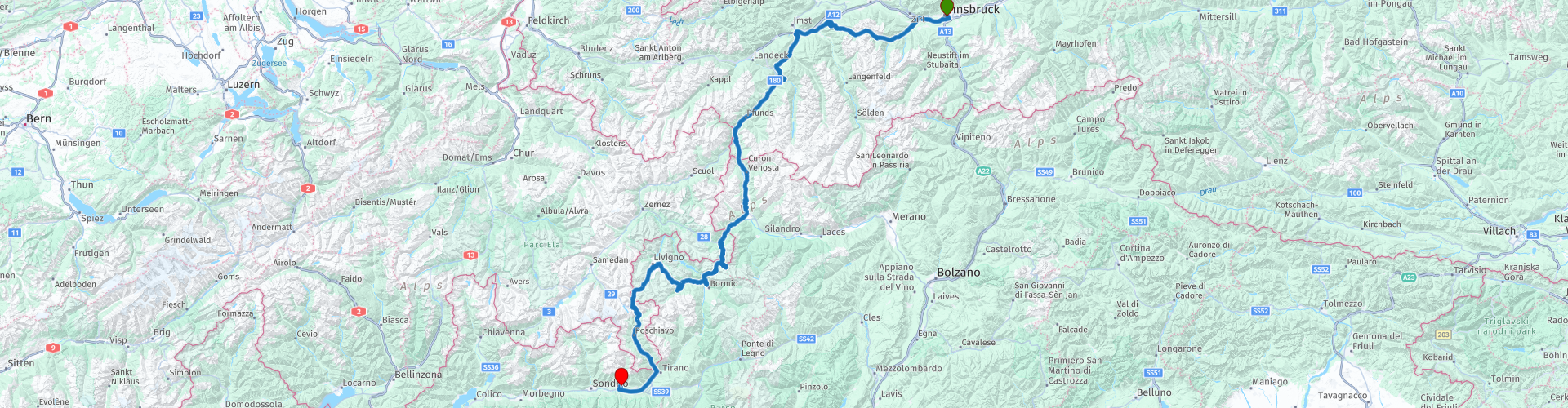
R01 - Innsbruck to Chiuro

This route was brought to you by:
RouteXpert Arno van Lochem - Senior RX
Last edit: 25-08-2021
 Route Summary
 The start of this route is at the loading bay of the OEBB, the Östereiche Bahn. From this point you immediately enter the motorcycle rider's paradise: The Alps.
This route includes the Umbrail and Stelvio pass, two wonderful passes in the Alps.
The end point is in Chiuro, Italy at a lovely hotel / pizzeria.
The route is for the more advanced motorcyclist. Certainly the Stelviopas requires good motor control, given the many (tight!) Hairpin bends.
 Share this route


Animation

Verdict


Duration
6h 10m

Mode of travel
Car or motorcycle

Distance
301.00 km

Countries


 RouteXpert Review
 The route starts in Innsbrück at the loading bay of the OEBB. There are daily car trains from Düsseldorf that have this place in the south of Austria as the end point. You can also reserve a place for the motorbike on this night train. Leave in the evening and arrive late the next morning. For more information see the link below.
In Innsbruck, the route comes almost directly past a petrol station. The gasoline prices in Austria are quite lower than in the Netherlands, so it is wise to refuel here.
Despite the fact that Innsbruck is a fairly large city with 130,000 inhabitants, after 3 kilometers you are already out of built-up areas. On the left and right you can already see the hilltops looming, that promises something! And indeed, at Kematen in Tirol you turn onto the L13. This road winds along a river, the Melach. Beautiful curves and steep cliffs alternate.
Once you have arrived on the L63, you drive along the viewing platform Gache Blick. This platform at 1,559 m above sea level offers a breathtaking view of the Inn Valley and the surrounding mountain ranges. In good weather you can see for miles.
A small warning is appropriate if you are afraid of heights. The platform still hangs a few meters above the ground, the 'floor' consisting of steel grids.
In the restaurant Gauchenblick there is a continuous exhibition called '3000m Vertikal'. This exhibition brings the visitor closer to the natural features of the natural park. An interactive walk through the different habitats - from the eternal ice to the dry steppe slopes in the valley - opens up interesting perspectives on plants, animals and people in the natural park. In addition, a film takes you back to a bygone era. The exhibition is open all day from Mon-Sun 10 am-6pm.
Leave the L63 at Kauns and continue on Reschen Bundesstraße. You will reach Lake Reschen via the Finstermünz Pass and Nauders. The Reschenmeer is a reservoir at about 1520 meters above sea level, just over the Austrian-Italian border, close to the Reschenpass. The lake is six kilometers long and is one kilometer wide in the widest places.
The reservoir was created in 1950 after the construction of a dam between 1948 and 1950. Before the dam was built, three more lakes could be found. Next to the Reschenmeer were the Mittersee and the nearby Haidermeer, which is located south of the Reschenmeer.
As a result of the dam, the original village of Graun and much of Reschen were flooded. 163 houses were demolished and 523 hectares of land were flooded. Today the church tower of Alt-Graun, the old village center of Graun, protruding above the surface reminds of the former village.
The route continues towards Switzerland and at Tubre the Italian-Swiss border is passed. Shortly after that, turn left onto the Umbrail Pass. A height of 2503m is indicated for this pass, however the official height is 2501m, due to corrections to the height determination by the Swiss authorities. In earlier times the Umbrailpass formed the connection between the Val Venosta (Vinschau) and the Valtellina. The current road was built in 1901. Only the last few years, the entire pass has been paved, previously several kilometers still consisted of gravel roads.
Due to heavy snowfall at the pass height, the road over the Umbrail Pass is closed to traffic from October to May every year.
On top of the Umbrail Pass, the border with Italy is crossed again and you arrive at the Stelvio Pass. The route keeps left and goes to the highest point of this 2758 meter high pass. Construction of this pass began in 1822. Barely three years later, the road was completed. Over the years, the pass has been adjusted in various places, in some places you can still see the old road.
Until 1915, the Stelvio Pass was ridden all year round by coaches. During the winter the road was kept passable by snow shovels. In 2020, however, the pass is closed to traffic from late October to early May.
On top, at an altitude of more than 2750 meters, you have - especially in good weather - a heck of a view. Take a moment to walk around here and check out the Tibet Hütt, an eatery built in the style of its name. Also from this point a great view over the shops on top of the pass and, even better, the descent towards Prato.
The descent of the Stelvio Pass is one that you will not soon forget. From the top to Bormio it is 20 km downhill! RP15 is a point where you have a beautiful view over the valley in the direction of Bormio. From this point you can follow the course of the Stelvio Pass for a few kilometers, really worth a stop.
After the Stelvio Pass the route winds further and after several hairpin bends and for example the Forcola di Livigno (2315m) the route in Brusio runs along the Viadotto elicoidale, or the spiral viaduct. Built in 1908, this viaduct is part of the Bernina railway section between Brusio and Campascio. During the construction of this railway, the engineers decided that the route should adapt to the natural landscape, avoiding unnecessary complexity. The spiral viaduct was - just like in many places in mountainous areas - the solution to meet all wishes, including bridging larger height differences at short distances. In the mountains, these types of buildings are usually poor or impossible to visit, but here the viaduct is beautifully visible.
After exiting the spiral viaduct, you will cross the Swiss-Italian border one more time to finally reach today's final destination in Chiuro after 300km of climbing and descending.
Have fun on this route!


 Links
Links  Usage
Usage Want to download this route?
You can download the route for free without MyRoute-app account. To do so, open the route and click 'save as'. Want to edit this route?
No problem, start by opening the route. Follow the tutorial and create your personal MyRoute-app account. After registration, your trial starts automatically.  Disclaimer
Use of this GPS route is at your own expense and risk. The route has been carefully composed and checked by a MyRoute-app accredited RouteXpert for use on TomTom, Garmin and MyRoute-app Navigation.
Changes may nevertheless have occurred due to changed circumstances, road diversions or seasonal closures. We therefore recommend checking each route before use.
Preferably use the route track in your navigation system. More information about the use of MyRoute-app can be found on the website under 'Community' or 'Academy'.

Graubunden
About this region
The Grisons or Graubünden, more formally the canton of the Grisons or the canton of Graubünden, is one of the twenty-six cantons of Switzerland. It has eleven regions, and its capital is Chur. The German name of the canton, Graubünden, translates as the "Grey Leagues", referring to the canton's origin in three local alliances, the Three Leagues. The other native names (Grischun in Rumantsch Grischun, Grisun in Lombard, and Grigioni in Italian) also refer to the Grey League. The Alpine ibex is the canton's heraldic symbol.
The largest and easternmost canton of Switzerland, it is also one of the three large southern Alpine cantons, along with Valais and Ticino. It is the most diverse canton in term of natural and cultural geography, as it encompasses both sides of the Alps and several natural and cultural regions. The diversity of the canton is often compared to that of Switzerland as a whole and warrants it the name of "Little Switzerland". The Grisons is bordered by four cantons: Ticino to the south; Uri to the west; and Glarus and St. Gallen to the north. The canton is also bordered by Liechtenstein to the north; Austria's federated states of Vorarlberg and Tyrol to the north and east; and Italy's autonomous province of South Tyrol and region of Lombardy to the south.
The Grisons is the only trilingual canton of Switzerland. It is also the only one where Romansh, Switzerland's fourth national language, has official status. Romansh language and culture is an important part of local identity. In 2020 the canton had a population of 200,096. It is the least densely populated canton of Switzerland. The only sizable city in the canton is Chur, as the majority of the population lives in mountainous areas, including some of the deepest valleys in Europe. The canton is a major tourist destination year-round, particularly for winter sports, and comprehends a large number of Alpine resort towns, notably Davos and St. Moritz. The canton is also renowned for its extensive narrow-gauge railway network, operated by the Rhaetian Railway.
Formerly occupied by the Rhaeti, most of the lands of the canton became once part of a Roman province called Raetia, which was established in 15 BC, with Curia, a settlement dating back to the Pfyn culture, as capital city. The area later became part of the lands of the diocese of Chur. The late middle ages saw the foundation of the League of God's House, the Grey League and the League of the Ten Jurisdictions. In 1471, an alliance gave birth to the Three Leagues, and before the end of the 15th century, the latter became an ally of the Old Swiss Confederacy. In 1803, the Three Leagues finally became one of the cantons of the Confederation.
Read more on Wikipedia
The largest and easternmost canton of Switzerland, it is also one of the three large southern Alpine cantons, along with Valais and Ticino. It is the most diverse canton in term of natural and cultural geography, as it encompasses both sides of the Alps and several natural and cultural regions. The diversity of the canton is often compared to that of Switzerland as a whole and warrants it the name of "Little Switzerland". The Grisons is bordered by four cantons: Ticino to the south; Uri to the west; and Glarus and St. Gallen to the north. The canton is also bordered by Liechtenstein to the north; Austria's federated states of Vorarlberg and Tyrol to the north and east; and Italy's autonomous province of South Tyrol and region of Lombardy to the south.
The Grisons is the only trilingual canton of Switzerland. It is also the only one where Romansh, Switzerland's fourth national language, has official status. Romansh language and culture is an important part of local identity. In 2020 the canton had a population of 200,096. It is the least densely populated canton of Switzerland. The only sizable city in the canton is Chur, as the majority of the population lives in mountainous areas, including some of the deepest valleys in Europe. The canton is a major tourist destination year-round, particularly for winter sports, and comprehends a large number of Alpine resort towns, notably Davos and St. Moritz. The canton is also renowned for its extensive narrow-gauge railway network, operated by the Rhaetian Railway.
Formerly occupied by the Rhaeti, most of the lands of the canton became once part of a Roman province called Raetia, which was established in 15 BC, with Curia, a settlement dating back to the Pfyn culture, as capital city. The area later became part of the lands of the diocese of Chur. The late middle ages saw the foundation of the League of God's House, the Grey League and the League of the Ten Jurisdictions. In 1471, an alliance gave birth to the Three Leagues, and before the end of the 15th century, the latter became an ally of the Old Swiss Confederacy. In 1803, the Three Leagues finally became one of the cantons of the Confederation.
View region
 Statistics
  21
21Amount of RX reviews (Graubunden)
 24696
24696Amount of visitors (Graubunden)
 2132
2132Amount of downloads (Graubunden)
 Route Collections in this region
 The 24 Most Beautiful Alpine Routes
The Alps, The Alps are a mountain range in Europe, stretching from the French Mediterranean coast in the southwest to the Pannonian Plain in the east. The area of the mountain range is more than 200,000 km².
In other words Passes and Mountain Roads!
Driving through the mountains is great! Especially over the mountain passes with hairpin bends and narrow winding roads. Every bend a different view where you can enjoy. There are many beautiful mountain passes in the Alps.
A selection that has also been incorporated into these routes:
The Stlevio Pass:
The Stelvio Pass, also known as Passo dello Stelvio, is mainly known for the stage in the Giro d'Italia. Due to the length and the difference in height, this pass is seen as one of the toughest tests in cycling. The Stelvio Pass reaches a maximum height of 2758 meters and is therefore one of the highest in the Alps. The pass connects the towns of Bormio and Prato Allo Stelvio. In winter the pass is closed due to heavy snowfall.
The Reschenpass:
The Reschenpass, also known as Passo di Resia, connects the Austrian state of Tyrol with the Italian province of South Tyrol. The pass reaches a maximum height of 1,504 meters and has been one of the most important north-south connections in the Alps in recent centuries. The pass was used long before Roman times. Along the way you will pass several highlights and historical relics. One of the highlights is the Reschensee. This lake was created after the construction of the dam and has completely submerged the village of Graun. The only thing that reminds of that is the clock tower in the middle of the lake.
Col du Galibier:
The French mountain pass Col du Galibier connects the towns of Saint-Michel-de-Maurienne and Briançon via the Col du Lautaret in the south and the Col du Télégraphe in the north. The mountain pass is part of the Tour de France and very much feared, due to the fact that it can only be reached via the other two mountain passes. The pass reaches a maximum height of 2646 meters. From there you can take a walk to the viewpoint at 2704 meters. You can admire the peaks of the Grand Galibier, Mont Blanc and La Meije here.
The Grossglockner High Alpine Road:
With a height of 3798 meters the Grossglockner is the highest mountain in Austria. To fully enjoy this impressive mountain, you can drive over the Grossglockner High Alpine Road and the accompanying pass. The route starts from Bruck am Grossglockner and ends in Heiligenblut. Of course you can drive in two directions. The pass reaches a maximum height of 2504 meters and is closed in winter due to heavy snowfall. Along the way you pass several stops with fun activities, information points, mountain huts and viewpoints. A visit to the Kaiser-Franz-Josefs-Höhe and Pasterzen Glacier is highly recommended.
The Col d'Izoard:
Just like the Col du Galibier, the Col d'Izoard is also part of a stage of the Tour de France. The mountain pass connects Briançon with the valley of the river Guil. The pass is partly located in the Regional Natural Park du Queyras and reaches a maximum height of 2360 meters. What is special about the Col d'Izoard is the barren and rocky landscape. Sometimes it feels like driving a car over the moon! Along the way you can stop at several points to enjoy the beautiful view.
The Bernina Pass:
The Bernina Express is one of the most famous rail trains in Switzerland and the Alps. The route is beautiful and partly included on the UNESCO World Heritage List. Parallel to the railway lies the Bernina pass, which connects the Veltlin valley with the Egandin valley. This beautiful Alpine road has a total length of 56 kilometers and reaches a maximum height of 2328 meters. Along the way you can enjoy views of the Morteratsch Glacier.
The Sella Pass:
The Sella Pass, also known as Passo di Sella, takes you over one of the most impressive mountain ranges in the Dolomites: the Sella massif. The pass connects Valle di Fassa with Val Gardena and reaches a maximum height of 2236 meters. At this height is also the border of the Italian provinces of Trentino and Bolzano. Along the way you can enjoy the view of this spectacular mountain world. Admire, for example, the three peaks of the Sasso Lungo massif, the Sella massif or the peaks of the Marmolada. You can also drive the Sella pass in combination with the Gardena pass, Pordoi pass and Campolongo pass.
The Grimsel Pass:
The Grimsel Pass connects Goms in Wallis with the Halis Valley in the Bernese Oberland. The pass reaches a maximum elevation of 2165 meters and is closed in winter due to snowfall. Over the centuries, the mountain pass has played an important role in trade between Switzerland and Italy. Now it is mainly the reservoirs that have an important function. These are used to generate electricity. The landscape you drive through is rugged, rocky and impressive. On top of the pass is a hotel and a restaurant with a special marmot park. The Dodensee (Totensee) is also located here. This lake owes its name to the many soldiers who died in the time of Napoleon.
The Gotthard Pass:
The Gotthard Pass, also known as Passo del San Gottardo and Saint Gotthard, connects the Swiss towns of Airolo and Andermatt. The mountain pass and associated tunnel are especially known among holidaymakers driving from Switzerland to Italy. But where the majority opt for the tunnel, it is precisely the pass that really completes the holiday. The Gotthard Pass has a length of about 26 kilometers and reaches a maximum height of 2106 meters. The route is beautiful and takes you along old villages and beautiful views.
The Silvretta High Alpine Road and Silvretta Pass:
The Paznaun Valley in Tyrol and the Montafon in Vorarlberg are connected by the Silvretta High Alpine Road. The route has a length of 22.3 kilometers and leads from Galtür to Partenen in 34 hairpin bends, via the 2032 meter high Bielerhöhe. The Silvrettasee is also located at this point, where you can enjoy a lovely walk. The pass is closed in winter due to snowfall.
The Simplon Pass:
Just like the Gotthard Pass, many holidaymakers also travel over the Simplon Pass every year. This mountain pass connects the Rhone Valley in the canton of Valais with the Valle d'Ossola in Piemonte. The pass is open all year round and reaches a maximum height of 2005 meters. Along the way you pass a number of buildings, including the well-known Simplon Hospiz from 1825. The hospiz is managed by the monks of St. Bernard. From the highest point on the pass, all kinds of hiking routes are possible and you will also come across a hotel where you can spend the night.
The Gerlos Pass:
The Gerlos Pass connects the Salzach Valley in the Salzburgerland with the Zillertal Valley in Tyrol. The pass is part of the Gerlos Alpenstraße and runs right through the Hohe Tauern National Park. Along the way you can enjoy beautiful views of the surroundings. The pass has a length of 12 kilometers and reaches a maximum height of 1531 meters. A ride over the Gerlos Pass can be ideally combined with a visit to the Krimmler Wasserfälle.
The Great St. Bernard Pass:
The Great St. Bernard Pass, better known as Col du Grand Saint Bernard, connects the Italian province of Valle d'Aosta with the Swiss canton of Valais. The pass is one of the highest in Switzerland and reaches a maximum height of 2469 meters. Like a number of other mountain passes in this list, the Great St. Bernard Pass has also been used as a connecting road for centuries. The pass is named after the St. Bernard dogs that used to help stranded travelers along with the monks. The pass is closed in winter.
The Timmelsjoch High Alpine Road:
The Timmelsjoch High Alpine Road connects the towns of Sölden in the Ötztal and Meran in South Tyrol. Tolls must be paid on the Hochgurgl - Moos route. Via a mountain road with about 60 hairpin bends you drive through a beautiful mountain world. With the Timmelsjoch Experience you can learn more about the history, the road and the environment via various stations. You can also visit the Top Mountain Crosspoint museum.
Col de l'Iseran:
With a maximum pass height of 2770 meters, the Col l'Iséran is one of the highest mountain passes in the Alps. The pass connects Bourg-Saint-Maurice with Bonneval-sur-Arc. Via a road full of hairpin bends you pass, among other things, Val-d'Isère and a side valley of the Maurienne that lies entirely in the National Park de la Vanoise. You can spot animals such as marmots and chamois and there is also a restaurant with a chapel on top of the pass.
The Gavia Pass:
The Gavia Pass (Italian Passo di Gavia) is a mountain pass in the Italian Alps, in the Lombardy region.
It is one of the highest pass roads in Europe. The road leads through the unspoilt Stelvio National Park. The road was built in the First World War to supply Italian soldiers who fought in the Italian-Austrian border area. The pass height is one of the most beautiful in the Alps. Here is the large Lago Bianco with, to the north, the mountain San Matteo (3684 meters). Lago Nero is slightly lower on the south side of the pass. Here the mountain group of the Adamello determines the view. There are many well-marked walks in the area. During the winter the pass is closed due to the heavy snowfall. The pass is often closed until May and June due to the large amount of snow.
Promoter has made a selection of the 24 Most Beautiful Alpine routes that they have set out in recent years.
The routes go through:
France
Austria
Switzerland
Italy
The most beautiful roads, the most beautiful views, the most beautiful viewpoints. The highest mountains, the fastest descents, hairpin bend after hairpin bend, you name it you can't get enough of it.
If you go on holiday in this region, take advantage of it, ALL routes in this collection have been checked and made equal for TomTom, Garmin and MyRoute-app Navigation by a MyRoute-app RouteXpert.
Have fun with this collection and while driving one of these routes. Enjoy all the beauty that the Alps and the Dolomites have to offer. Click on “View route” to read the review of the chosen route.
I would like to hear your findings about the route(s).
View Route Collection
11 day trip from the Netherlands
8 countries in 11 days; The Netherlands, Germany, Austria, Italy, Switzerland, France, Luxembourg and Belgium. This route collections consists of 10 routes that I have driven with friends in the summer of 2019.
The start is in Geldermalsen Netherlands, the first 7 days you drive through the Netherlands, Germany, Austria, Italy, Switzerland, France and a piece of Luxembourg with overnight stays in hotels.
The last three days you stay in Barweiler (D) in the Eifel and you drive two beautiful tours through the Eifel, Luxembourg and parts of the Belgian Ardennes.
There is no highway in the routes, only beautiful provincial and country roads, many beautiful passes with beautiful panoramas.
Be sure to check whether the passes are open before you leave.
These are routes for experienced drivers.
View Route Collection