02 Von Samnaun nach Welschnofen via Timmelsjoch und weitere Paesse und Bergstrassen

This route was brought to you by:
RouteXpert David Ruprecht
Last edit: 20-02-2023
 Route Summary
 The length of the tour and the varied types of road demand a lot from the driver, above all stamina and attention.
Important: The route over the Timmelsjoch costs a fee per motorcycle and must be paid shortly before the top of the pass. There is a small information brochure and a sticker from the Timmelsjoch.
I rate the route with 4.5 stars because it is very varied, exciting and not only offers a lot in terms of driving, but also has something for the soul with the motorcycle museum and the various vantage points such as Lake Carezza.
 Share this route


Animation

Verdict


Duration
15h 4m

Mode of travel
Car or motorcycle

Distance
582.72 km

Countries


 RouteXpert Review
 The length of the tour and the varied types of road demand a lot from the driver, above all stamina and attention.
Important: The route over the Timmelsjoch costs a fee per motorcycle and must be paid shortly before the top of the pass. There is a small information brochure and a sticker from the Timmelsjoch.
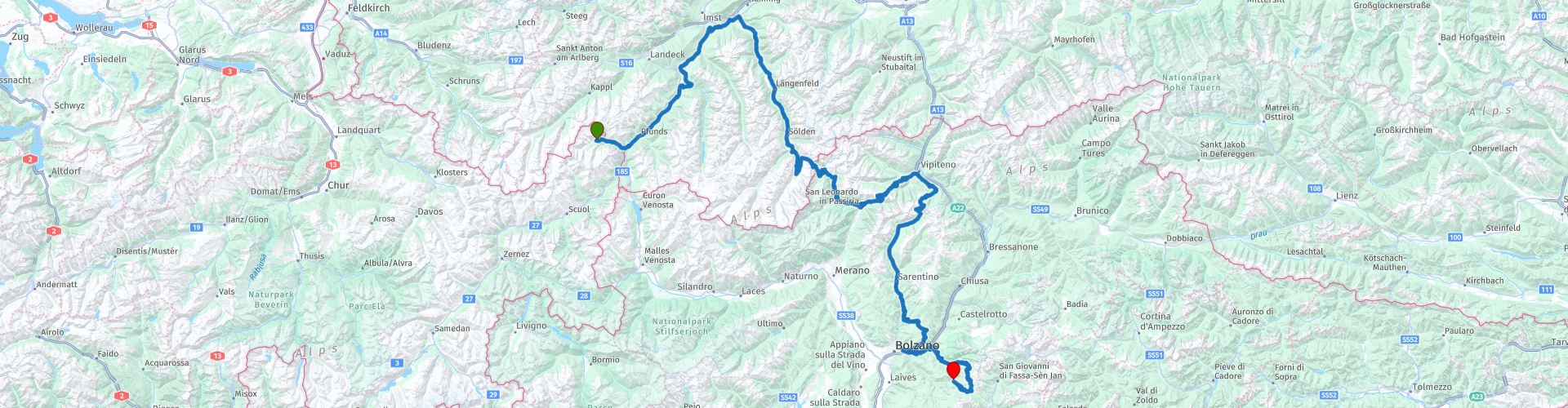
From Samnaun it's the same route down into the Inn Valley. There we turn left and drive down the valley. If you like it faster, you can skip five waypoints here and take the expressway. To enjoy the beautiful mountain region with the typical Austrian villages, however, the main road through fields and villages is recommended. In Prutz we leave the valley floor and, via a few bends in the road, get high above the valley and are soon on the Pillerhöhe, where coffee and a photogenic view await. The sometimes very narrow and dreamy road leads us parallel to the Inn Valley in the direction of Ötztal. Shortly before Pitztal we go down to the right and our route leads south of the Inn on a side road to just after Roppen, where we briefly switch to Tiroler Strasse and then immediately to Ötztaler Strasse.
You can immediately feel the increase in traffic on this important axis, but it goes smoothly up the wide expressway in the direction of Timmelsjoch. If you like to take more time and split up this day tour, we recommend a trip to the Ötztal Glacier Road. Just don't miss the junction at Unterwald.
After Zwieselstein you feel the height for the first time and realize that we are on a real pass road. The many winter sports lifts in Obergurgl give an idea that the region is not only suitable for motorbike tours. The beautiful switchbacks, the impressive peaks to the left and right and the sparse fauna make the heart of the pass driver beat faster and after a few last, steep needle bends, we reach the highlight of today's ride: the Timmelsjoch motorcycle museum.
At 2171m above sea level we come to the payment point (toll for the pass road), where the famous motorcycle museum can also be visited. An absolute must. Completely destroyed in a fire catastrophe in 2021, it was immediately rebuilt and offers hundreds of unique vintage cars and showpieces of motorcycle history on 4500 m2. The attached restaurant is highly recommended, because after this trip and the visit, hunger is noticeable.
Back in the saddle we pay the toll and drive up to the pass at 2491m above sea level. Here, too, it is worth stopping and pulling out the camera. If you want, you can take a quick look at the road construction museum, where the history of this extraordinary route is shown with powerful pictures. After the tunnel shortly after the top of the pass, it's down into South Tyrol. You can feel the rising heat, the view is phenomenal. But already in St. Leonhard we leave the main road and drive to the Jaufenpass. After a short photo stop, it's down to Gasteig and via Castel Tasso up again to the Penser Joch. The view and the mountain restaurant at the top of the pass invite you to have a coffee and a well-deserved break.
Now we're heading south towards Bolzano. Shortly before the city, shortly after Ponticino, we switch to the side road to avoid the stop'n go of city traffic. We drive briefly parallel to the notorious Brenner autobahn before we climb up near Blumau. The next destination is the Niger Pass. It is less famous and therefore less busy, but the road is well developed for winter sports. It would be a shame not to take in the view and snap a few photos.
The last few kilometers down to Lake Karersee can be driven in a few minutes, a stop at this world-famous lake is essential. The clear turquoise of the water and the steep mountain ridges behind it invite you as a motif for lasting memories. Until 2018 everything was surrounded by high forests, which were almost completely destroyed in a terrible autumn storm. The destructive force of this storm is still impressively visible today. Before it gets dark we go down to Nova Levante, Welschnofen, where today's tour ends. We recommend the Hotel Diana at the upper end of the town towards Lake Carezza, as well as the Hotel Pardeller in the middle of the village of Nova Levante. In terms of culinary delights, Marion's Grillstube in Welschnofen cannot be beaten, advance reservations are required.

 Links
Links  Usage
Usage Want to download this route?
You can download the route for free without MyRoute-app account. To do so, open the route and click 'save as'. Want to edit this route?
No problem, start by opening the route. Follow the tutorial and create your personal MyRoute-app account. After registration, your trial starts automatically.  Disclaimer
Use of this GPS route is at your own expense and risk. The route has been carefully composed and checked by a MyRoute-app accredited RouteXpert for use on TomTom, Garmin and MyRoute-app Navigation.
Changes may nevertheless have occurred due to changed circumstances, road diversions or seasonal closures. We therefore recommend checking each route before use.
Preferably use the route track in your navigation system. More information about the use of MyRoute-app can be found on the website under 'Community' or 'Academy'.

Tyrol
About this region
Tyrol (; German: Tirol [tiˈʁoːl] (listen); Italian: Tirolo) is a state (Land) in western Austria. It comprises the Austrian part of the historical Princely County of Tyrol. It is a constituent part of the present-day Euroregion Tyrol–South Tyrol–Trentino (together with South Tyrol and Trentino in Italy). The capital of Tyrol is Innsbruck.
Read more on Wikipedia
View region
 Statistics
  38
38Amount of RX reviews (Tyrol)
 52071
52071Amount of visitors (Tyrol)
 6041
6041Amount of downloads (Tyrol)
 Route Collections in this region
 The 24 Most Beautiful Alpine Routes
The Alps, The Alps are a mountain range in Europe, stretching from the French Mediterranean coast in the southwest to the Pannonian Plain in the east. The area of the mountain range is more than 200,000 km².
In other words Passes and Mountain Roads!
Driving through the mountains is great! Especially over the mountain passes with hairpin bends and narrow winding roads. Every bend a different view where you can enjoy. There are many beautiful mountain passes in the Alps.
A selection that has also been incorporated into these routes:
The Stlevio Pass:
The Stelvio Pass, also known as Passo dello Stelvio, is mainly known for the stage in the Giro d'Italia. Due to the length and the difference in height, this pass is seen as one of the toughest tests in cycling. The Stelvio Pass reaches a maximum height of 2758 meters and is therefore one of the highest in the Alps. The pass connects the towns of Bormio and Prato Allo Stelvio. In winter the pass is closed due to heavy snowfall.
The Reschenpass:
The Reschenpass, also known as Passo di Resia, connects the Austrian state of Tyrol with the Italian province of South Tyrol. The pass reaches a maximum height of 1,504 meters and has been one of the most important north-south connections in the Alps in recent centuries. The pass was used long before Roman times. Along the way you will pass several highlights and historical relics. One of the highlights is the Reschensee. This lake was created after the construction of the dam and has completely submerged the village of Graun. The only thing that reminds of that is the clock tower in the middle of the lake.
Col du Galibier:
The French mountain pass Col du Galibier connects the towns of Saint-Michel-de-Maurienne and Briançon via the Col du Lautaret in the south and the Col du Télégraphe in the north. The mountain pass is part of the Tour de France and very much feared, due to the fact that it can only be reached via the other two mountain passes. The pass reaches a maximum height of 2646 meters. From there you can take a walk to the viewpoint at 2704 meters. You can admire the peaks of the Grand Galibier, Mont Blanc and La Meije here.
The Grossglockner High Alpine Road:
With a height of 3798 meters the Grossglockner is the highest mountain in Austria. To fully enjoy this impressive mountain, you can drive over the Grossglockner High Alpine Road and the accompanying pass. The route starts from Bruck am Grossglockner and ends in Heiligenblut. Of course you can drive in two directions. The pass reaches a maximum height of 2504 meters and is closed in winter due to heavy snowfall. Along the way you pass several stops with fun activities, information points, mountain huts and viewpoints. A visit to the Kaiser-Franz-Josefs-Höhe and Pasterzen Glacier is highly recommended.
The Col d'Izoard:
Just like the Col du Galibier, the Col d'Izoard is also part of a stage of the Tour de France. The mountain pass connects Briançon with the valley of the river Guil. The pass is partly located in the Regional Natural Park du Queyras and reaches a maximum height of 2360 meters. What is special about the Col d'Izoard is the barren and rocky landscape. Sometimes it feels like driving a car over the moon! Along the way you can stop at several points to enjoy the beautiful view.
The Bernina Pass:
The Bernina Express is one of the most famous rail trains in Switzerland and the Alps. The route is beautiful and partly included on the UNESCO World Heritage List. Parallel to the railway lies the Bernina pass, which connects the Veltlin valley with the Egandin valley. This beautiful Alpine road has a total length of 56 kilometers and reaches a maximum height of 2328 meters. Along the way you can enjoy views of the Morteratsch Glacier.
The Sella Pass:
The Sella Pass, also known as Passo di Sella, takes you over one of the most impressive mountain ranges in the Dolomites: the Sella massif. The pass connects Valle di Fassa with Val Gardena and reaches a maximum height of 2236 meters. At this height is also the border of the Italian provinces of Trentino and Bolzano. Along the way you can enjoy the view of this spectacular mountain world. Admire, for example, the three peaks of the Sasso Lungo massif, the Sella massif or the peaks of the Marmolada. You can also drive the Sella pass in combination with the Gardena pass, Pordoi pass and Campolongo pass.
The Grimsel Pass:
The Grimsel Pass connects Goms in Wallis with the Halis Valley in the Bernese Oberland. The pass reaches a maximum elevation of 2165 meters and is closed in winter due to snowfall. Over the centuries, the mountain pass has played an important role in trade between Switzerland and Italy. Now it is mainly the reservoirs that have an important function. These are used to generate electricity. The landscape you drive through is rugged, rocky and impressive. On top of the pass is a hotel and a restaurant with a special marmot park. The Dodensee (Totensee) is also located here. This lake owes its name to the many soldiers who died in the time of Napoleon.
The Gotthard Pass:
The Gotthard Pass, also known as Passo del San Gottardo and Saint Gotthard, connects the Swiss towns of Airolo and Andermatt. The mountain pass and associated tunnel are especially known among holidaymakers driving from Switzerland to Italy. But where the majority opt for the tunnel, it is precisely the pass that really completes the holiday. The Gotthard Pass has a length of about 26 kilometers and reaches a maximum height of 2106 meters. The route is beautiful and takes you along old villages and beautiful views.
The Silvretta High Alpine Road and Silvretta Pass:
The Paznaun Valley in Tyrol and the Montafon in Vorarlberg are connected by the Silvretta High Alpine Road. The route has a length of 22.3 kilometers and leads from Galtür to Partenen in 34 hairpin bends, via the 2032 meter high Bielerhöhe. The Silvrettasee is also located at this point, where you can enjoy a lovely walk. The pass is closed in winter due to snowfall.
The Simplon Pass:
Just like the Gotthard Pass, many holidaymakers also travel over the Simplon Pass every year. This mountain pass connects the Rhone Valley in the canton of Valais with the Valle d'Ossola in Piemonte. The pass is open all year round and reaches a maximum height of 2005 meters. Along the way you pass a number of buildings, including the well-known Simplon Hospiz from 1825. The hospiz is managed by the monks of St. Bernard. From the highest point on the pass, all kinds of hiking routes are possible and you will also come across a hotel where you can spend the night.
The Gerlos Pass:
The Gerlos Pass connects the Salzach Valley in the Salzburgerland with the Zillertal Valley in Tyrol. The pass is part of the Gerlos Alpenstraße and runs right through the Hohe Tauern National Park. Along the way you can enjoy beautiful views of the surroundings. The pass has a length of 12 kilometers and reaches a maximum height of 1531 meters. A ride over the Gerlos Pass can be ideally combined with a visit to the Krimmler Wasserfälle.
The Great St. Bernard Pass:
The Great St. Bernard Pass, better known as Col du Grand Saint Bernard, connects the Italian province of Valle d'Aosta with the Swiss canton of Valais. The pass is one of the highest in Switzerland and reaches a maximum height of 2469 meters. Like a number of other mountain passes in this list, the Great St. Bernard Pass has also been used as a connecting road for centuries. The pass is named after the St. Bernard dogs that used to help stranded travelers along with the monks. The pass is closed in winter.
The Timmelsjoch High Alpine Road:
The Timmelsjoch High Alpine Road connects the towns of Sölden in the Ötztal and Meran in South Tyrol. Tolls must be paid on the Hochgurgl - Moos route. Via a mountain road with about 60 hairpin bends you drive through a beautiful mountain world. With the Timmelsjoch Experience you can learn more about the history, the road and the environment via various stations. You can also visit the Top Mountain Crosspoint museum.
Col de l'Iseran:
With a maximum pass height of 2770 meters, the Col l'Iséran is one of the highest mountain passes in the Alps. The pass connects Bourg-Saint-Maurice with Bonneval-sur-Arc. Via a road full of hairpin bends you pass, among other things, Val-d'Isère and a side valley of the Maurienne that lies entirely in the National Park de la Vanoise. You can spot animals such as marmots and chamois and there is also a restaurant with a chapel on top of the pass.
The Gavia Pass:
The Gavia Pass (Italian Passo di Gavia) is a mountain pass in the Italian Alps, in the Lombardy region.
It is one of the highest pass roads in Europe. The road leads through the unspoilt Stelvio National Park. The road was built in the First World War to supply Italian soldiers who fought in the Italian-Austrian border area. The pass height is one of the most beautiful in the Alps. Here is the large Lago Bianco with, to the north, the mountain San Matteo (3684 meters). Lago Nero is slightly lower on the south side of the pass. Here the mountain group of the Adamello determines the view. There are many well-marked walks in the area. During the winter the pass is closed due to the heavy snowfall. The pass is often closed until May and June due to the large amount of snow.
Promoter has made a selection of the 24 Most Beautiful Alpine routes that they have set out in recent years.
The routes go through:
France
Austria
Switzerland
Italy
The most beautiful roads, the most beautiful views, the most beautiful viewpoints. The highest mountains, the fastest descents, hairpin bend after hairpin bend, you name it you can't get enough of it.
If you go on holiday in this region, take advantage of it, ALL routes in this collection have been checked and made equal for TomTom, Garmin and MyRoute-app Navigation by a MyRoute-app RouteXpert.
Have fun with this collection and while driving one of these routes. Enjoy all the beauty that the Alps and the Dolomites have to offer. Click on “View route” to read the review of the chosen route.
I would like to hear your findings about the route(s).
View Route Collection
The 12 most beautiful car and motorcycle routes in Carinthia
“Motorradland Kärnten” where you feel so wonderfully welcome as a motorcyclist!
Own website for motorcyclists, own curated routes, hotels, campsites and guest houses with attention for motorcyclists, a wonderful area where motorcyclists are very popular.
Kärnten or Carinthia, at the crossroads of the Germanic, Slavic and Roman worlds. Three cultures within a few kilometres, southern flair, culinary delights, cross-border tours. Breakfast in Italy, lunch in Slovenia, dinner in Austria - all in one day. Experience the diversity in the borderless Alps-Adriatic region, the area for motorcyclists.
Extensive day trips on winding mountain paths, romantic panoramic routes and beautiful lakes, here the 12 TOP routes Kärnten / Carinthia. Enjoy!
View Route Collection