R06 NSW Jenolan to Sydney

This route was brought to you by:
RouteXpert Hans van de Ven (Mr.MRA)
Last edit: 15-04-2021
 Route Summary
 Australia is very big; 8 million km2, that is more than 226 times larger than the Netherlands! Has a diversity of flora and fauna; the most diverse types of plants, trees and animals, especially birds and a lot of typical Australian marsupials, that you won't find anywhere else in the world!
Enormous enjoyment of all the beautiful things: From the always green tropical rain forests to the vast Outback; from the desert to the countless and tranquil idyllic palm beaches; from the winter sports areas in the southeast to the bustling and impressive millions of cities of Melbourne, Sydney and Perth.
You will see and experience it all in this great tour through Australia, a tour you will never forget!
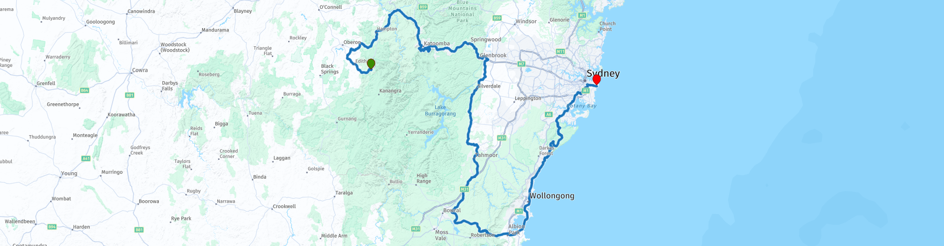
Starting point: Jenolan, Jenolan Caves House
End point: Sydney, Hotel Bondi
The route has been made the same for TomTom, Garmin and MyRoute-app Navigation users.
ATTENTION: LEFT DRIVING!
 Share this route


Animation

Verdict


Duration
11h 49m

Mode of travel
Car or motorcycle

Distance
432.10 km

Countries

 RouteXpert Review
 This route takes you to Sydney. Sydney is the largest and oldest city in Australia and the capital of the state of New South Wales. You can start or end this tour as indicated in Sydney. Stay in Sydney for a few days to explore this city and climb the Sydney Harbor Bridge, among other things.
You leave for Katoomba along the various lookout points, so if you missed one in the previous route, you can still visit it. You can drink coffee at the Katoomba Falls Kiosk and also visit the Katoomba Falls. This is a segmented waterfall that is close to Echo Point near Katoomba on the Kedumba River and descends to the Jamison Valley in the Blue Mountains National Park. Then you get 3 more viewpoints including Sublime Point, this is a top on the edge of the plateau, where you really have a fantastic view. Then you go via the east side of the Blue Mountains National Park to the south where you can stop for lunch at Picton at George IV. Picton is a small town in the Macarthur region, in the Wollondilly Shire, in southwest Sydney. The city is located 80 kilometers southwest of Sydney, close to Camden and Campbelltown. It is also the administrative center of Wollondilly Shire. After lunch, refuel and continue south, up to the Macquarie Pass National Park.
The Macquarie Pass is an eight-kilometer stretch of the Illawarra Highway through the Macquarie Pass National Park. It was opened in 1898. The Macquarie Pass connects the southern highland town of Robertson with the coastal town of Albion Park and descends the Illawarra Escarpment via a very narrow lane, which has several sections with one lane and is usually two lanes with double "non-overtaking" lines. It is located in the local government area of Shellharbour. This part of the roadway is very steep and contains many hairpin bends, which means that buses and trucks have to get into some bends to make it. Due to its nature, the pass is notorious for accidents and drivers and riders must be careful. The Macquarie pass can be closed after heavy rainfall due to flooding in the upper half of the pass. Cars and motorcyclists can choose to use Jamberoo Mountain Road between Robertson and Jamberoo, while trucks are advised to use Mount Ousley Road (Southern Freeway) and Picton Road as an alternative.
The road is very popular with motorcyclists on weekends and public holidays. The Shellharbour and Wingecarribee Councils and the NSW Roads and Maritime Services have therefore published a safety brochure with the title 'Motorcycling Macquarie Pass'.
After this cornering you head towards the coast to drive to Sydney. You will pass through Wollongong, this is an industrial city. The third largest city in the state and 10th city in the country is located in the Illawarra district. Wollongong lies 82 kilometers south of Sydney by rail. The city of Wollongong has 234,482 inhabitants. At the Otford Lookout, you have a nice view of the ocean, be sure to stop and capture. You can make a stop in the Royal National Park, at the "Weir Cafe". After this last stop, head into the hustle and bustle of Sydney, refuel right in front of the hotel and then check in at the hotel on Bondi Beach and enjoy a few days in this metropolis.
This route, rated with 4 stars, goes mainly through beautiful roads, through a few small towns where you can stop for a snack and beautiful nature areas and you pass countless viewpoints.
General info:
New South Wales is a state of Australia with Sydney as its capital, and is often abbreviated to NSW. The three most important cities are, from north to south, Newcastle, Sydney and Wollongong, which are all on the coast. Other cities are Albury, Broken Hill, Dubbo, Tamworth, Armidale, Lismore, Nowra and Coffs Harbor.
The state is located on the east coast of the continent, north of the state of Victoria and south of the state of Queensland. In the west it borders South Australia. The coast borders the Tasman Sea. New South Wales has two federal enclaves: the Australian Capital Territory (ACT) and the Jervis Bay Territory.
New South Wales can be physically divided into four parts:
A narrow coastal strip, with a climate whose temperature varies from temperate on the extreme south coast to subtropical on the Queensland border.
The mountainous areas of the Greater Australian Separation Mountains and the highlands that surround it, such as the Southern Highlands, Central Tablelands and the regions of New England. Even though the mountain walls are not very steep, many mountain tops exceed 1000 meters, of which Mount Kosciuszko reaches 2229 meters as the highest peak.
The agricultural plains, which make up a large part of the area of the state. These areas are much less densely populated than the coast. This part includes the Riverina region.
The dry, desert-like plains in the far north-west of the state, which are unsuitable for settlements of any size.
It is the oldest colony of the former Australian colonies of the United Kingdom. The colony was founded in 1788 and originally included much more of the Australian mainland. At that time, the western half of the colony was called New Holland and the eastern half was New South Wales. New Holland was controlled from Sydney.
During the nineteenth century, large areas were separated around the British colonies Van Diemen's Land (Tasmania) (1825), Victoria (1851), Queensland (1859) and South Australia (1836) (which at that time also included the Northern Territory) to shape. These colonies and Western Australia voted in 1901 to continue together as the Commonwealth of Australia.
Tourist attractions in the state include; The Blue Mountains, west of Sydney, a national park including the Three Sisters rock formation; The Hunter Valley, 150 km north of Sydney, the oldest wine region in Australia. The Snowy Mountains, on the border with Victoria, a popular ski resort, and the capital, Sydney.


 Links
Links  Usage
Usage Want to download this route?
You can download the route for free without MyRoute-app account. To do so, open the route and click 'save as'. Want to edit this route?
No problem, start by opening the route. Follow the tutorial and create your personal MyRoute-app account. After registration, your trial starts automatically.  Disclaimer
Use of this GPS route is at your own expense and risk. The route has been carefully composed and checked by a MyRoute-app accredited RouteXpert for use on TomTom, Garmin and MyRoute-app Navigation.
Changes may nevertheless have occurred due to changed circumstances, road diversions or seasonal closures. We therefore recommend checking each route before use.
Preferably use the route track in your navigation system. More information about the use of MyRoute-app can be found on the website under 'Community' or 'Academy'.