R17 NT Ilperle to Alice Springs

This route was brought to you by:
RouteXpert Hans van de Ven (Mr.MRA)
Last edit: 12-04-2020
 Route Summary
 Australia is very large; 8 million km2, which is more than 226 times larger than the Netherlands! Has a diversity of flora and fauna; the most diverse types of plants, trees and animals, especially birds and a lot of typical Australian marsupials, which you will not find anywhere else in the world!
Enjoy all the beauty immensely: From the evergreen tropical rainforests, to the vast Outback; from the desert to the countless and peaceful idyllic palm beaches; from the winter sports areas in the southeast to the vibrant and impressive metropolis of Melbourne, Sydney and Perth.
You will see it all and experience it in this amazing tour through Australia, a tour to remember!
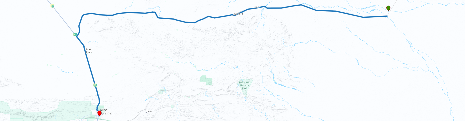
Starting point: Ilperle, Jervois Station Campground
End Point: Alice Springs, DoubleTree by Hilton Hotel
The route has been created for TomTom, Garmin and MyRoute-app Navigation users.
ATTENTION: DRIVE LEFT!
 Share this route


Animation

Verdict


Duration
3h 40m

Mode of travel
Car or motorcycle

Distance
349.40 km

Countries

 RouteXpert Review
 Alice Springs is the fifth most popular region in the Northern Territory with overseas tourists.
In Alice Springs you can stay a few days, there is plenty to see, such as the Desert Park, the Pyndan Camel Tracks, Museum of Central Australia, the Alice Springs Reptile Center and the Alice Springs Telegraph Station Historical Reserve. There are also several beautiful viewpoints where you really have a beautiful view and can take beautiful photos, such as the Heavitree Gap Look Out, the Emily Gap & Jessie Gap. Of course you will sleep in a good hotel with swimming pool, so you can travel well rested.
The Plenty Highway, although called a 'highway', is a dirt track. You MUST make sure you have a very suitable vehicle (4wd, motor home, motorbike) to traverse this road, whether traveling east or west!
Information about its condition can be obtained from the Harts Range Police Station, 112 kilometers (70 miles) from the Stuart Highway. Keep in mind that the unpaved road is not in best condition, can be very dusty and there may be lots of rocks on it. Fuel and food are available from Jervois Homestead and Atitjere community.
This route also goes through the outback, these are the regions that are far from civilization. The outback covers nearly three-quarters of Australia and mainly covers the Northern Territory and Western Australia, and parts of the states of Queensland, New South Wales and South Australia.
The term outback includes various landscapes and climatic zones. Large parts of the outback in Western Australia are inaccessible: sometimes there is no rain here in years, while in summer the temperature rises above 50 ° C. The Queensland outback, on the other hand, consists partly of tropical rainforest.
The characteristics of the outback are:
- Only a few paved roads are present. Farms (stations) are often located on sandy paths that can only be driven with off-road vehicles. It is no exception when a farm is 80 kilometers from the paved road.
- Farms are self-catering. It is no problem if a supermarket cannot be visited for weeks.
- Settlements with several houses, a gas station, a supermarket, a garage, a bank and catering facilities are hundreds of kilometers apart.
- Children receive remote education via radio (School of the Air) and the Internet.
- In the event of serious illness and accident, the Royal Flying Doctor Service (RFDS) is called upon.
Camels were imported from the Middle East in 1870. They live partly on farms, partly in the wild.
- Of the approximately 300,000 Aborigines (approximately 1.5% of Australia's total population), approximately 20% live in the outback, most of them in reservations.
This 4-star rated route will push your limits and drive on paved and unpaved roads. Take your time if you are in the Atitjere community, you can fill up here and have some food and drinks.
General info:
The Northern Territory consists of the originally northern part of the state of South Australia. However, this is again contested by the state of Western Australia, as the heir to New Holland. It is now an area with limited self-government, has an area of 1,349,129 km² and a quarter of a million inhabitants. The population density is extremely low with one inhabitant on five square kilometers. The capital is Darwin, the northernmost city in the country.
The Territory, has the image of a large nature reserve and the few inhabitants like to describe themselves as tough, hardy nature people. Two of the most visited natural areas in Australia are located in the Northern Territory: the tropical Kakadu National Park in the north and the world-famous Uluṟu-Kata Tjuṯa National Park in the south (Uluṟu used to be known as Ayers Rock). The province is also home to the wonderful Devils Marbles Conservation Reserve.
Most of the Simpson Desert is in the southeast corner, while the Tanami Desert is in the west. The MacDonnell Mountains extend east and west from Alice Springs. Arnhemland, a large area belonging to the Aboriginal population, is located to the north of the territory, and the Barkly Plateau to the northeast.
The entire Northern Territory has only two cities: Darwin and Palmerston. Other places include Alice Springs, Katherine, Tennant Creek, and Jabiru.
The Northern Territory is home to only 1% of Australia's total population, more than half of whom live in the capital, Darwin. 32.5% of these are Aborigines.


 Links
Links  Usage
Usage Want to download this route?
You can download the route for free without MyRoute-app account. To do so, open the route and click 'save as'. Want to edit this route?
No problem, start by opening the route. Follow the tutorial and create your personal MyRoute-app account. After registration, your trial starts automatically.  Disclaimer
Use of this GPS route is at your own expense and risk. The route has been carefully composed and checked by a MyRoute-app accredited RouteXpert for use on TomTom, Garmin and MyRoute-app Navigation.
Changes may nevertheless have occurred due to changed circumstances, road diversions or seasonal closures. We therefore recommend checking each route before use.
Preferably use the route track in your navigation system. More information about the use of MyRoute-app can be found on the website under 'Community' or 'Academy'.