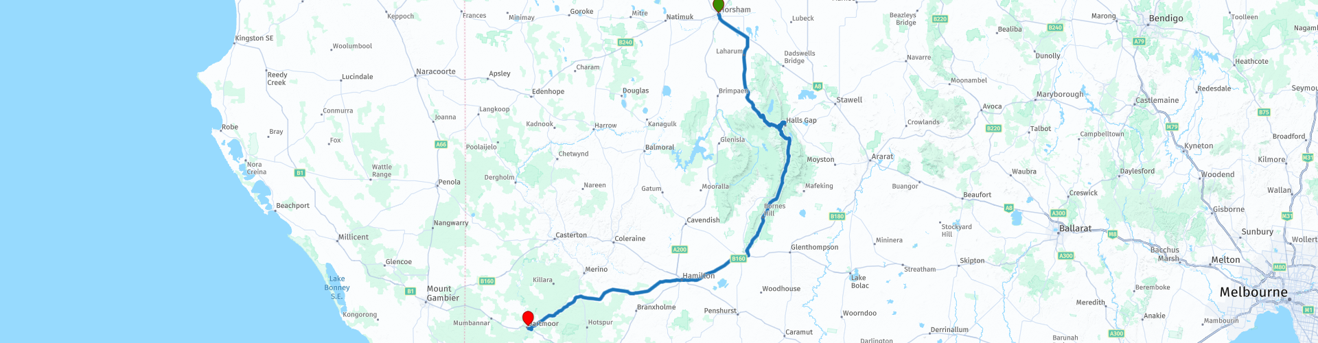
R50 VIC Horsham to Dartmoor

This route was brought to you by:
RouteXpert Hans van de Ven (Mr.MRA)
Last edit: 09-01-2021
 Route Summary
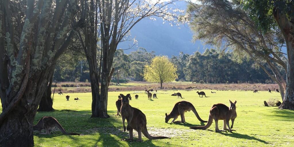
 Australia is very big; 8 million km2, that is more than 226 times larger than the Netherlands! Has a diversity of flora and fauna; the most diverse types of plants, trees and animals, especially birds and a lot of typical Australian marsupials, which you will not find anywhere else in the world!
Enjoy all the beauty enormously: From the evergreen tropical rainforests, to the vast Outback; from the desert to the countless and quiet idyllic palm beaches; from the winter sports areas in the south-east to the vibrant and impressive metropolis of Melbourne, Sydney and Perth.
You will see and experience it all in this great tour of Australia, a tour to remember!
Starting Point: Horsham, Horsham House Motor Inn
End Point: Dartmoor, Dartmoor Hotel / Motel
The route is made the same for TomTom, Garmin and MyRoute-app Navigation users.
 Share this route


Animation

Verdict


Duration
7h 30m

Mode of travel
Car or motorcycle

Distance
259.17 km

Countries

 RouteXpert Review
 This very varied, ancient landscape stretches from north to south, in spring many flowers are in bloom and the park turns into a colorful sea of flowers. Take a walk to enjoy the impressive waterfalls where liters of water fall down hard, such as the MacKenzie Falls and rock carvings of Aboriginal people that are more than five thousand years old. The many vantage points also treat you to views of the mountains and cliffs. Walk to Reeds Lookout or The Balconies for the best panoramic views of the park.
But also a visit to Halls Gap, for lunch. With about 480 inhabitants, Halls Gap is one of Australia's smaller cities, but plenty of choice for lunch.
After the lunch stop back into the park and then stop at the Silverband Falls and take a walk to the waterfall again. After this stop, wind further south, where you can stop at the viewpoint over Mount Abrupt at the town of Dunkheld. In the next town, Hamilton, you have the opportunity to stretch your legs while refueling and then head back to the finish in Dartmoor, where you should definitely take a look at Dartmoor's Avenue of honor. Where you will see that they have made special memorials here to commemorate those who fought and died in world wars. The carvings of the Dartmoor memorial tree are one of the most unusual and personal memorials in the Southwest.
This 4-star rated route goes over mostly very good roads, and along many beautiful viewpoints in the Grampians National Park, where you occasionally come through a walk to the most beautiful spots in this park.
General info:
Victoria is the smallest state on the Australian mainland. It is located in the southeastern corner of the continent and has a population of over 6.5 million in an area of 227,416 km². The border with New South Wales is the south bank of the River Murray. It borders South Australia to the west and the Indian Ocean to the south. Brass Strait lies between Victoria and Tasmania. Victoria, like Queensland, is named after Queen Victoria.
The capital Melbourne with about 70% of the state's population and located on the north side of Port Philipbaai has Australia's busiest container port. The city is the state's economic and cultural center. This town is also home to the State Library of Victoria.
There are wide variations in climate in Victoria, from the moderately humid eastern Gippsland to the snow-capped, almost 2000 meter high Australian Alps in the northeast, and from the hot semi-desert of the northwest to the lush irrigation areas along the Murray. Mount Bogong is the highest mountain in Victoria.
Gold was found near Raspberry Creek in Victoria in the 19th century. This gold was of very high quality. Hamlets were founded along the brook. The hamlet of A1 Mine Settlement takes its name from this period.
History
The area was already inhabited when the first Anglo-Australians settled there in 1803. In 1835 John Batman bought from the native population an area on which the city of Melbourne was to be built. In 1851 the area was detached from New South Wales and in 1855 it was given the status of a self-governing colony. A parliament consisting of two chambers was elected. The first Prime Minister was William Haines. In 1901, the six Australian colonies formed the Commonwealth of Australia, and Victoria has been a federal state of that country ever since.

 Links
Links  Usage
Usage Want to download this route?
You can download the route for free without MyRoute-app account. To do so, open the route and click 'save as'. Want to edit this route?
No problem, start by opening the route. Follow the tutorial and create your personal MyRoute-app account. After registration, your trial starts automatically.  Disclaimer
Use of this GPS route is at your own expense and risk. The route has been carefully composed and checked by a MyRoute-app accredited RouteXpert for use on TomTom, Garmin and MyRoute-app Navigation.
Changes may nevertheless have occurred due to changed circumstances, road diversions or seasonal closures. We therefore recommend checking each route before use.
Preferably use the route track in your navigation system. More information about the use of MyRoute-app can be found on the website under 'Community' or 'Academy'.