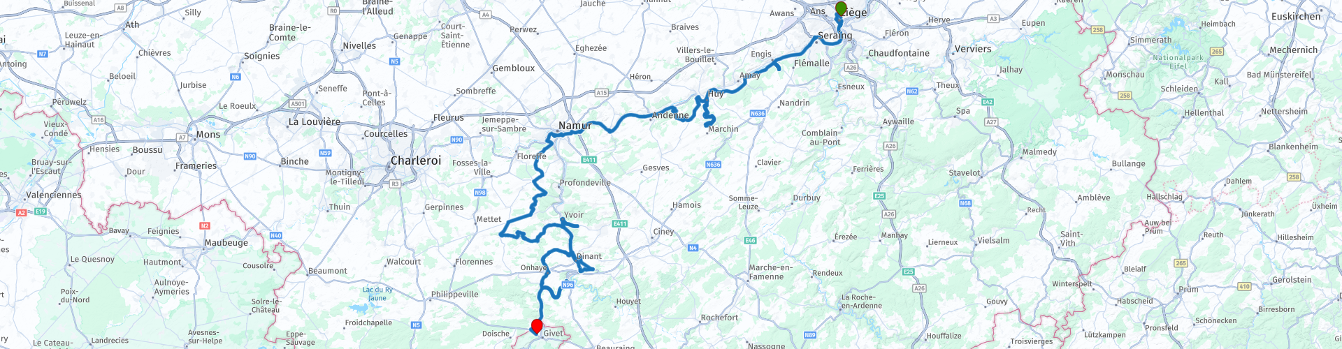
Luik Givet de Citadellen langs de Maas

This route was brought to you by:
RouteXpert Stijn Claus
Last edit: 28-06-2021
 Route Summary
 We have lunch at the Abbey of Maredsous.
The roads are mainly secondary roads.
Most of the sights are off the main road, but these are clearly marked from the main road. Please note that the road surfaces of the access roads are not always in good condition.
 Share this route


Animation

Verdict


Duration
4h 29m

Mode of travel
Car or motorcycle

Distance
211.38 km

Countries


 RouteXpert Review
 Today there are still many remains of the citadel visible. From here you get a beautiful panoramic view of the city center of Liège.
Then we follow the banks of the Maas to Huy. Here we find the Huy citadel. This was once one of the most beautiful castles of our region, but due to its strategic location, the castle must make way for a sober but impregnable fortress. In 1940, the Germans turned it into one of the most lurid prisons in Belgium: for more than 7 years more than 7,000 people were locked up in the dungeons as the last leg before they boarded the train from death to concentration camp.
The route takes us to Namur, where the Counts of Namur built their residence. Between the 15th and 18th centuries the fortress was repeatedly besieged, so that it always passed into different hands. Skilful military architects and engineers are trying in vain to turn it into an impregnable stronghold, making the citadel of Namur in the 18th century one of the largest in Europe, with 80 hectares of defenses. It was Napoleon who gave her the name "termite mound of Europe" because of the miles of underground passages.
From Namur the route goes further south, we no longer follow the banks of the Maas and drive through the woods to the abbey of Maredsous. In addition to a guesthouse and a reception building with shops, museum space, this Benedictine monastery houses a restaurant.
After lunch at the abbey we drive back to the Maas valley. This brings us to the medieval ruins of the castle and the fortified village of Poilvache. From the rocky hill on which the fortress is located, one has a good view over the valley of the Maas.
A dozen kilometers further on the route arrives in Dinant. Here we meet two reinforced locations.
The first fortifications on the rocks above Dinant date back to the 11th century. They have to protect the border town of the prince-diocese of Liège on one of the few bridges over the Meuse against the counts of Namur, with the castle of Crèvecoeur on the other side.
From Dinant we drive to France, on the way we pass by the castle of Freÿr It is called a greatly reduced Versailles. It was originally an Renaissance castle, expanded in the 18th century and was once the residence for dukes and their royal guests.
The route ends at the Citadel of Givet. This fort was built in 1555 by order of Emperor Charles V. He needed a strategic position in the heart of Europe and the location of Givet was perfect in his eyes.
Part of the Citadel of Givet is the Fort Charlemont. You can visit this historic monument. The fort has, among other things, an 800-meter long tunnel system, 3 kilometers of trenches and an abandoned village with 48 buildings.
This route gets 4 stars because of the beautiful view of the route and the many nice sights.


 Links
Links  Usage
Usage Want to download this route?
You can download the route for free without MyRoute-app account. To do so, open the route and click 'save as'. Want to edit this route?
No problem, start by opening the route. Follow the tutorial and create your personal MyRoute-app account. After registration, your trial starts automatically.  Disclaimer
Use of this GPS route is at your own expense and risk. The route has been carefully composed and checked by a MyRoute-app accredited RouteXpert for use on TomTom, Garmin and MyRoute-app Navigation.
Changes may nevertheless have occurred due to changed circumstances, road diversions or seasonal closures. We therefore recommend checking each route before use.
Preferably use the route track in your navigation system. More information about the use of MyRoute-app can be found on the website under 'Community' or 'Academy'.

Liège Province
About this region
Liège (French: [ljɛʒ]; Walloon: Lîdje [liːtʃ]; Dutch: Luik [lœyk] (About this soundlisten); German: Lüttich [ˈlʏtɪç] (About this soundlisten)) is the easternmost province of Wallonia and Belgium.
It borders (clockwise from the north) the Dutch province of Limburg, the German states of North Rhine-Westphalia and Rhineland-Palatinate, Diekirch in Luxembourg, the Belgian Walloon (French-speaking) provinces of Luxembourg, Namur and Walloon Brabant and the Belgian Flemish (Dutch-speaking) provinces of Flemish Brabant and Limburg.
Part of the eastern-most area of the province, bordering Germany, is the German-speaking region of Eupen-Malmedy, which became part of Belgium in the aftermath of World War I.
The capital and the largest city of the province is the city of the same name, Liège. The province has an area of 3,857 km2 (1,489 sq mi), and a population of 1,106,992 as of January 2019.[4]
Read more on Wikipedia
It borders (clockwise from the north) the Dutch province of Limburg, the German states of North Rhine-Westphalia and Rhineland-Palatinate, Diekirch in Luxembourg, the Belgian Walloon (French-speaking) provinces of Luxembourg, Namur and Walloon Brabant and the Belgian Flemish (Dutch-speaking) provinces of Flemish Brabant and Limburg.
Part of the eastern-most area of the province, bordering Germany, is the German-speaking region of Eupen-Malmedy, which became part of Belgium in the aftermath of World War I.
The capital and the largest city of the province is the city of the same name, Liège. The province has an area of 3,857 km2 (1,489 sq mi), and a population of 1,106,992 as of January 2019.[4]
View region
 Statistics
  75
75Amount of RX reviews (Liège Province)
 38835
38835Amount of visitors (Liège Province)
 18367
18367Amount of downloads (Liège Province)
 Route Collections in this region
 The 10 most beautiful car and motorcycle routes in Limburg
Limburg, who thinks of Limburg, thinks of flan, coal mines, marl and the hill country. The coal mines have been closed for almost 40 years, the last load of coal was brought up from the Oranje-Nassau coal mine in Heerlen on 31 December and, as they say, South Limburg was transformed from Black to Green and unfortunately there is still little left. view of this period.
But not only pie, marl and coal in Limburg, but also a very beautiful province to tour by car or motorcycle and enjoy all the beauty that the province of Limburg has to offer. For this, the MyRoute app RouteXpert has put together a Top 10 of Car and Motorcycle routes for you.
All routes in this collection have been checked and made equal for TomTom, Garmin and MyRoute-app Navigation by a MyRoute-app RouteXpert.
If you think, I have a very nice route that should certainly not be missing from this collection, send it to:
email: routeexpert@myrouteapp.com
Subject: New Route for the Top 10 collection Province of Limburg composed by Hans van de Ven.
The route will then be reviewed and then added to the Top 10.
To make the Top 10 also the Top 10, 1 route will have to disappear from the Top 10, you can indicate this when submitting the new route.
Have fun with this collection and while driving one of these routes. Enjoy all the beauty that the Netherlands and in particular the province of Limburg has to offer. Click on “View route” to read the review of the chosen route.
I would like to hear your findings about the route(s).
View Route Collection
Top 5 Car and Motorcycle Routes in the Eifel
The Eifel is the eastern part of the medium plateau Eifel-Ardennes. It is located north of the Moselle and west of the Rhine. The largest part is in Germany, a small part is in Belgium, in the East Cantons. The German part of Eifel is located in the federal states of North Rhine-Westphalia and Rhineland-Palatinate. The highest point is the Hohe Acht with 747 meters.
Several chains can be distinguished in the Eifel:
The northernmost part is called the Nordeifel, which in Belgium connects to the High Fens;
To the east of this is the Ahrgebirge, this part is located north of the Ahr in the Ahrweiler district;
South of the Ahr is the Hohe Eifel (or Hocheifel), of which the Hohe Acht (747 m) is the highest point, and also the highest point in the entire Eifel region;
To the west, near the Belgian border, the hills are known as Schneifel, part of the wider Snow Eifel area with peaks reaching up to 698 metres;
South and east of the Hohe Eifel is the Volcano-Eifel, a volcanic area with many crater lakes (Maare).
The southern part of the Eifel is less high. The area is bisected by streams and rivers running southwards. These streams flow into the Moselle. The largest of these rivers is the Kyll; the hills around this river are known as the Kyllwald;
In the south, the Eifel ends in the Voreifel.
In the north of the Eifel there are some large reservoirs. The largest of these is the reservoir in the Roer that was created by the construction of the Roerdal dam.
The Nürburgring is also located in the Eifel, a well-known car circuit for Formula 1 races, among other things. Since 2004, part of the north of the Eifel has become the Eifel National Park. This National Park falls entirely within the German-Belgian nature park High Fens-Eifel. Another part of the Eifel falls within the South Eifel Nature Park.
Well-known throughout the Netherlands and Belgium by car and motorcyclists, so reason enough for the MyRoute app RouteXpert to compile a Top 5 of Car and Motorbike routes for you.
All routes in this collection have been checked and made equal for TomTom, Garmin and MyRoute-app Navigation by a MyRoute-app RouteXpert.
If you think, I have a very nice route that should certainly not be missing from this collection, send it to:
email: routeexpert@myrouteapp.com
Subject: New Route for the Top 5 collection Eifel composed by Hans van de Ven.
The route will then be reviewed and then added to the Top 5. To make the Top 5 also the Top 5, 1 route will have to disappear from the Top 5, you can indicate this when submitting the new route.
Have fun with this collection and while driving one of these routes. Enjoy all the beauty that the Eifel has to offer. Click on “View route” to read the review of the chosen route.
I would like to hear your findings about the route(s).
View Route Collection