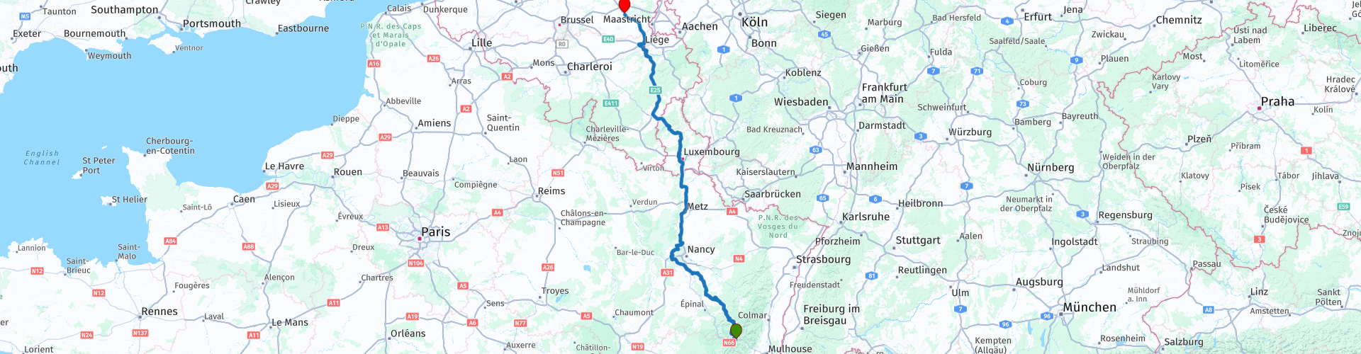
Col de Bussang to Hasselt while driving by the Moselle river and crossing the Ardennes

This route was brought to you by:
RouteXpert Guy Heyns - Sr RouteXpert
Last edit: 10-12-2024
 Route Summary
 Could it be faster, maybe. Could it be more beautiful? Maybe so, but not in one day if you also want to enjoy it a bit. And luckily that is also possible on this route!
This route combines the return to Belgium with a little "hydrocultural" knowledge.
After all, the route runs for a large part via the well-known Moselle and the Canal de l'Est back through Luxembourg to Flanders.
The road may be long, but it is beautiful and there is something to see if you are willing to pay attention to it.
That is why we almost wanted to give this route a five star rating, but at the last minute we withdrew our opinion. Finally, you also do a large part of 'boring', but insurmountable highway kilometers.
Nevertheless, this route is definitely recommended. She will take you where you need to be from the Vosges via fun, interesting roads and you will learn something too!
 Share this route


Animation

Verdict


Duration
9h 41m

Mode of travel
Car or motorcycle

Distance
511.24 km

Countries


 RouteXpert Review
 The ridge that remained formed the border between France and Germany from 1871 to 1918. 1918, you read that right. The end of the First World War. Afterwards, boundaries were literally shifted, but you can already imagine that the terrain of the Vosges during WW I was a particularly turbulent area…
This is the return route that takes you from Col de Bussang in the Vosges back to the Flemish Hasselt in Limburg.
Nevertheless, this route cannot be called traditional as you can also learn something from it. At least if you have an eye and attention for it.
We start in Hotel du Col de Bussang after we have said goodbye to our host and lady.
A first petrol station can be found 27 kilometers after the start of the route. However, remember that refueling in Luxembourg is much cheaper. Fill in appropriately. A small recommendation can also be to stop at an Intermarché or another department store along the way to stock up on a picnic. Really good bars & cafes are harder to find in the first part. Beautiful picnic areas, on the other hand…
Picnic stuff crammed into the suitcases you drive towards rp 15 where you will find a lovely picnic area. You will really have no trouble finding the right place for a short break. If the weather conditions are not ideal for an outdoor break, the boulangerie slightly further away may offer a pleasant and, above all, covered alternative.
But before you arrive at one of these points, you first pass the Moselle and shortly afterwards the Canal de l'Est. I would like to say a few words about that….
The Moselle originates in the Vosges. You may have driven one of the “Ultimate Collection” routes that took you to the source of this all-important river. You probably also remember how small this well actually was.
The Canal de 'l'Est has been an inseparable part of the Moselle since 1874 when they started building the canal.
The canal has a length of no less than 439 km and connects the Saône with the Meuse and the Moselle. It is therefore not surprising that the skippers gave the canal the names 'Canal de la Meuse' and 'Canal des Vosges' for the northern and southern parts of the canal respectively.
A large part of this route goes along the Moselle and the Canal de l'Est, but from rp 16 it gets really interesting.
The Canal de l'Est not only connects the Meuse with the Saône & Moselle, it also 'replaces' the Moselle on those parts that are less navigable or even not navigable at all. The canal must therefore remain close to the Moselle and so it does… The canal sometimes even crosses the Moselle, which really does require some thinking. After all, how do you let a canal, which is fed by the Moselle itself, flow completely over the river without the waters touching? It goes without saying that the 152 locks and pump systems play a very important role in this. But just think… we are talking about construction in 1874….
Near rp 16 near Flavigny-sur-Moselle you can visit such an aqueduct if you wish. Still a bit of a hallucinatory sight... Aqueducts were therefore not only built by the Romans...
From rp 16 it is best to keep the camera or the mounted GoPro at the ready. From now on you will experience a dignified example of hydroponics and that for about 130 km. You literally flirt along the Moselle, the Canal and the many other water features. Those with an eye for it will also see the prosperity and other consequences of the Moselle and associated waterworks.
At rp 19 you can, if desired, take a break where you can enjoy a more extensive lunch along the Terrouin. You are only 174 km away, but you have been in the saddle for almost 5 hours, so think about it.
'Le Terrouin' is an interesting gabber… David who takes on Goliath and wins the battle too. The small, 30-kilometre-long river was solely responsible for the fact that the Moselle, 300 000 years ago and originally flowing into the Meuse, had to shift its bed eastwards in the direction of the Rhine. Today the entire course of the Terrouin is a protected nature reserve. At 'Le Pavillon Blue', our lunch spot, you can see the Terrouin flowing into the Moselle after it has won the battle for the river bed with flying colours.
After lunch we flirt a little further with the river and canal and finally, after the first 200 kilometers, we start the first highway ride.
50 kilometers further and after passing/crossing the cities of Metz & Thionville you can respectfully say goodbye to the mighty Moselle. You pass it for the last time near Thionville.
You quickly reach the border crossing between France and Luxembourg. You can take a coffee stop on the Aire de Berchem. I would postpone refueling for a while and – just like in the approach route – I advise against leaving your motorcycles unattended.
You round Luxembourg city and Ettelbruck, after which the route spoils you with a non-motorway passage. After all, we drive inland via the Parc Naturel de la Haute-Sûre to Pommerloch where we can stock up on the last Luxembourg's valued petrol. If desired, a coffee stop can be arranged in the stylish Pommerloch Hotel just before the petrol stations. The choice is yours, but please note that this is the last stop before we start the last highway trek to the farewell point in Hasselt.
Fortunately, there you will also find the necessary sanitary and other facilities so that you can say goodbye to your travel colleagues – fully illuminated – in one of the restaurants or not.
Due to the many boring highway kilometers, the route cannot of course obtain a five-star rating, but to be honest, because of the aquacultural wealth it really doesn't make much difference. A passage through this area will teach you a lot if you want to pay attention to it. The roads are particularly well laid out and will sometimes pleasantly surprise you – also in terms of views and driving pleasure. Therefore an absolute well-deserved 4 stars for this instructive return route.


 Links
Links  Usage
Usage Want to download this route?
You can download the route for free without MyRoute-app account. To do so, open the route and click 'save as'. Want to edit this route?
No problem, start by opening the route. Follow the tutorial and create your personal MyRoute-app account. After registration, your trial starts automatically.  Disclaimer
Use of this GPS route is at your own expense and risk. The route has been carefully composed and checked by a MyRoute-app accredited RouteXpert for use on TomTom, Garmin and MyRoute-app Navigation.
Changes may nevertheless have occurred due to changed circumstances, road diversions or seasonal closures. We therefore recommend checking each route before use.
Preferably use the route track in your navigation system. More information about the use of MyRoute-app can be found on the website under 'Community' or 'Academy'.

Wallonia
About this region
The Walloon Region (French: Région wallonne [ʁeʒjɔ̃ walɔn]; German: Wallonische Region; Dutch: Waals gewest), usually simply referred to as Wallonia (; French: Wallonie [walɔni]; Walloon: Waloneye; German: Wallonien [vaˈloːni̯ən] (listen) or Wallonie [valoˈniː]; Dutch: Wallonië [ʋɑˈloːnijə] (listen)), is one of the three Regions of Belgium—alongside the Flemish Region and the Brussels-Capital Region.Covering the southern portion of the country, Wallonia is primarily French-speaking, and accounts for 55% of Belgium's territory, but only a third of its population. The Walloon Region was not merged with the French Community of Belgium, which is the political entity responsible for matters related mainly to culture and education, because the French Community of Belgium encompasses both Wallonia and the bilingual Brussels-Capital Region.
There is a German-speaking minority in eastern Wallonia, resulting from the annexation of three cantons previously part of the German Empire at the conclusion of World War I. This community represents less than 1% of the Belgian population. It forms the German-speaking Community of Belgium, which has its own government and parliament for culture-related issues.
During the industrial revolution, Wallonia was second only to the United Kingdom in industrialization, capitalizing on its extensive deposits of coal and iron. This brought the region wealth, and from the beginning of the 19th to the middle of the 20th century, Wallonia was the more prosperous half of Belgium. Since World War II, the importance of heavy industry has greatly diminished, and the Flemish Region has exceeded Wallonia in wealth as Wallonia has declined economically. Wallonia now suffers from high unemployment and has a significantly lower GDP per capita than Flanders. The economic inequalities and linguistic divide between the two are major sources of political conflicts in Belgium and a major factor in Flemish separatism.
The capital of Wallonia is Namur, and the most populous city is Charleroi. Most of Wallonia's major cities and two-thirds of its population lie along the east-west aligned Sambre and Meuse valley, the former industrial backbone of Belgium. To the north of this valley, Wallonia lies on the Central Belgian Plateau, which, like Flanders, is a relatively flat and agriculturally fertile area. The south and southeast of Wallonia is made up of the Ardennes, an expanse of forested highland that is less densely populated.
Wallonia borders Flanders and the Netherlands (the province of Limburg) in the north, France (Grand Est and Hauts-de-France) to the south and west, and Germany (North Rhine-Westphalia and Rhineland-Palatinate) and Luxembourg (Capellen, Clervaux, Esch-sur-Alzette, Redange and Wiltz) to the east. Wallonia has been a member of the Organisation Internationale de la Francophonie since 1980.
Read more on Wikipedia
There is a German-speaking minority in eastern Wallonia, resulting from the annexation of three cantons previously part of the German Empire at the conclusion of World War I. This community represents less than 1% of the Belgian population. It forms the German-speaking Community of Belgium, which has its own government and parliament for culture-related issues.
During the industrial revolution, Wallonia was second only to the United Kingdom in industrialization, capitalizing on its extensive deposits of coal and iron. This brought the region wealth, and from the beginning of the 19th to the middle of the 20th century, Wallonia was the more prosperous half of Belgium. Since World War II, the importance of heavy industry has greatly diminished, and the Flemish Region has exceeded Wallonia in wealth as Wallonia has declined economically. Wallonia now suffers from high unemployment and has a significantly lower GDP per capita than Flanders. The economic inequalities and linguistic divide between the two are major sources of political conflicts in Belgium and a major factor in Flemish separatism.
The capital of Wallonia is Namur, and the most populous city is Charleroi. Most of Wallonia's major cities and two-thirds of its population lie along the east-west aligned Sambre and Meuse valley, the former industrial backbone of Belgium. To the north of this valley, Wallonia lies on the Central Belgian Plateau, which, like Flanders, is a relatively flat and agriculturally fertile area. The south and southeast of Wallonia is made up of the Ardennes, an expanse of forested highland that is less densely populated.
Wallonia borders Flanders and the Netherlands (the province of Limburg) in the north, France (Grand Est and Hauts-de-France) to the south and west, and Germany (North Rhine-Westphalia and Rhineland-Palatinate) and Luxembourg (Capellen, Clervaux, Esch-sur-Alzette, Redange and Wiltz) to the east. Wallonia has been a member of the Organisation Internationale de la Francophonie since 1980.
View region
 Statistics
  103
103Amount of RX reviews (Wallonia)
 29773
29773Amount of visitors (Wallonia)
 24754
24754Amount of downloads (Wallonia)
 Route Collections in this region
 The 10 most beautiful car and motorcycle routes in Limburg
Limburg, who thinks of Limburg, thinks of flan, coal mines, marl and the hill country. The coal mines have been closed for almost 40 years, the last load of coal was brought up from the Oranje-Nassau coal mine in Heerlen on 31 December and, as they say, South Limburg was transformed from Black to Green and unfortunately there is still little left. view of this period.
But not only pie, marl and coal in Limburg, but also a very beautiful province to tour by car or motorcycle and enjoy all the beauty that the province of Limburg has to offer. For this, the MyRoute app RouteXpert has put together a Top 10 of Car and Motorcycle routes for you.
All routes in this collection have been checked and made equal for TomTom, Garmin and MyRoute-app Navigation by a MyRoute-app RouteXpert.
If you think, I have a very nice route that should certainly not be missing from this collection, send it to:
email: routeexpert@myrouteapp.com
Subject: New Route for the Top 10 collection Province of Limburg composed by Hans van de Ven.
The route will then be reviewed and then added to the Top 10.
To make the Top 10 also the Top 10, 1 route will have to disappear from the Top 10, you can indicate this when submitting the new route.
Have fun with this collection and while driving one of these routes. Enjoy all the beauty that the Netherlands and in particular the province of Limburg has to offer. Click on “View route” to read the review of the chosen route.
I would like to hear your findings about the route(s).
View Route Collection
Top 5 Car and Motorcycle Routes in the Eifel
The Eifel is the eastern part of the medium plateau Eifel-Ardennes. It is located north of the Moselle and west of the Rhine. The largest part is in Germany, a small part is in Belgium, in the East Cantons. The German part of Eifel is located in the federal states of North Rhine-Westphalia and Rhineland-Palatinate. The highest point is the Hohe Acht with 747 meters.
Several chains can be distinguished in the Eifel:
The northernmost part is called the Nordeifel, which in Belgium connects to the High Fens;
To the east of this is the Ahrgebirge, this part is located north of the Ahr in the Ahrweiler district;
South of the Ahr is the Hohe Eifel (or Hocheifel), of which the Hohe Acht (747 m) is the highest point, and also the highest point in the entire Eifel region;
To the west, near the Belgian border, the hills are known as Schneifel, part of the wider Snow Eifel area with peaks reaching up to 698 metres;
South and east of the Hohe Eifel is the Volcano-Eifel, a volcanic area with many crater lakes (Maare).
The southern part of the Eifel is less high. The area is bisected by streams and rivers running southwards. These streams flow into the Moselle. The largest of these rivers is the Kyll; the hills around this river are known as the Kyllwald;
In the south, the Eifel ends in the Voreifel.
In the north of the Eifel there are some large reservoirs. The largest of these is the reservoir in the Roer that was created by the construction of the Roerdal dam.
The Nürburgring is also located in the Eifel, a well-known car circuit for Formula 1 races, among other things. Since 2004, part of the north of the Eifel has become the Eifel National Park. This National Park falls entirely within the German-Belgian nature park High Fens-Eifel. Another part of the Eifel falls within the South Eifel Nature Park.
Well-known throughout the Netherlands and Belgium by car and motorcyclists, so reason enough for the MyRoute app RouteXpert to compile a Top 5 of Car and Motorbike routes for you.
All routes in this collection have been checked and made equal for TomTom, Garmin and MyRoute-app Navigation by a MyRoute-app RouteXpert.
If you think, I have a very nice route that should certainly not be missing from this collection, send it to:
email: routeexpert@myrouteapp.com
Subject: New Route for the Top 5 collection Eifel composed by Hans van de Ven.
The route will then be reviewed and then added to the Top 5. To make the Top 5 also the Top 5, 1 route will have to disappear from the Top 5, you can indicate this when submitting the new route.
Have fun with this collection and while driving one of these routes. Enjoy all the beauty that the Eifel has to offer. Click on “View route” to read the review of the chosen route.
I would like to hear your findings about the route(s).
View Route Collection