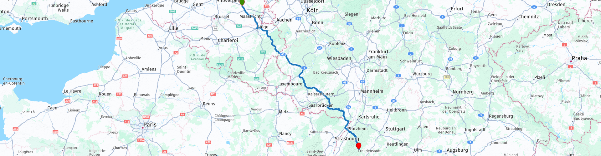
1 Schwarzwaldroute from Tessenderlo to Lauterbad over Verviers

This route was brought to you by:
RouteXpert Guy Heyns - Adv. RouteXpert
Last edit: 10-12-2024
 Route Summary
 Ze maakt in het begin veel gebruik van snelweg en gaat niet door Luxemburg zoals je normaal zou verwachten. De route loopt over Verviers.
Deze snelweg is veel makkelijker te rijden, minder verkeer en zeer goed gericht in de richting van het Zwarte Woud.
Houd er rekening mee dat er bijna geen parkeerplaatsen langs dit deel van de route zijn, aangezien er minder verkeer is.
We raden u ten zeerste aan om de pauzeer- en tankopties die op de route zijn aangegeven goed te bekijken. Zorg ervoor dat u het vermoeidheidsniveau op deze lange route van bijna 500 km in evenwicht houdt.
Maar wees gerust, de route is leuk om te rijden, zowel voor gevorderden als beginners, en hij brengt je in een uitstekende tijd diep het Schwarzwald in en over uitstekende wegen, zeker na Baden Baden.
 Share this route


Animation

Verdict


Duration
7h 20m

Mode of travel
Car or motorcycle

Distance
497.82 km

Countries


 RouteXpert Review
 It is an approach route, which means that it does contain some motorway, but the choice of these motorways was made very deliberately about Verviers. This highway is generally very quiet, making the use of this route highly recommended for newbies. However, pay attention to the marked pause points and use them to monitor the level of fatigue of the beginners. But the experts don't have to worry either. Because of the little traffic you will make good progress and you will quickly be in Germany where you can go 'loose' on the permitted sections. In any case, keep it safe so that you can certainly take the last part, from Baden Baden to Leuterbad.
Also mention that this is route 1 from the "Alps-Dolomite 2020" route collection. This route collection takes you from Belgium to the Austrian and Italian Alps and Dolomites and back again in 9 days.
The route departs from the Total petrol station on the E313 in Tessenderlo. Excellent meeting place because all facilities are provided and it is also already on the highway that we will be using.
You quickly reach Liège and Verviers, after which you reach the German border along the High Fens, Malmédy and St. Vith.
Nice to know is that the small river 'Our' actually forms the border between Belgium and Germany and almost entirely the German-Luxembourg border. Swim and you are over because the Our is actually not that big. At least not when the weather is nice. When it rains downpours, the Our can swell dangerously hard. That is why the bridge over which you enter Germany is located fairly high.
Once in Germany, a pleasant and fun highway awaits you. Sufficiently 'winding' and there are parts where you can go 'loose'. However, at route point 6 you leave the motorway, after which a small break is planned just before Pirmasens.
After this break, regional roads will be followed that will take you to France via rp 10. There a short stretch of highway is taken to just before Roppenheim, where the highway is left again in the direction of the German border. This is formed by the majestic Rhine. The Rhine and lock complex that you drive over (rp11) is impressive to say the least. Also pay attention to the road… several drivers have their eyes out here and sometimes lose attention for the passing motorcyclist.
Once the Rhine (and the accompanying crowds) has passed, another pause point is inserted at RP 12. You are free to use it or not, but it also allows you to refuse.
Perhaps it is still advisable to stop here and to consult with yourself and / or colleagues, because you will have to make a decision here ... Are you going to continue to follow the predetermined route or are you going to use the opportunity to famous Schwardwaldhochstrasse - the infamous '500' - to take at rp 13?
We leave the choice up to you, but personally we prefer the predetermined route.
The 500 is fun to do and definitely something that should be on your bucket list as a motorcyclist. To be fair, the '500' is a beautiful road with beautiful asphalt that also meanders wonderfully through the tops of the Schwarzwald treetops. Definitely a winner. But…, the Strasse is overcrowded, and certainly on a sunny day… There are many (and sometimes incomprehensible) speed limits in force and “Die Polizei” looks on suspiciously and also with penance. And actually (sorry for the sermon) they are right. Some fellow motorcyclists are so excited by this beautiful asphalt that they assume racing allures with all the consequences ...
But, you must have ridden them once that Schwarzwaldhochstrasse, and then preferably in both directions, so….
However, for this route we prefer to take the parallel road over Forbach. A wonderfully winding road through the Black Forest that is not (yet) very busy, moreover. After Forbach the road also meanders nicely with the Murg, a small river, and so you drive absolutely relaxed in the direction of Freudenstadt & Lauterbad where we are going to stay.
The hotel Gut Lauterbad (rp17) is a nice, cheap hotel where you can park under cover and also has a nice restaurant, specializing in (own) trout and steak. But lovers of other dishes will certainly find something to their liking. A good Wiener Schnitzel simply tastes good (and they are delivered here in German format ...).
The route is and remains an approach route and is intended to cover as many kilometers as possible in the most pleasant way possible. The route certainly succeeds with the (excellent) motorway choices. But just because there is so much motorway in it, the five-star rating is just a bit too high. But much is made up for by the piece after Baden Baden. Super relaxing and pleasant to do after this distant ride that actually brought you 500 kilometers further quite quickly, well and properly.


 Links
Links  Usage
Usage Want to download this route?
You can download the route for free without MyRoute-app account. To do so, open the route and click 'save as'. Want to edit this route?
No problem, start by opening the route. Follow the tutorial and create your personal MyRoute-app account. After registration, your trial starts automatically.  Disclaimer
Use of this GPS route is at your own expense and risk. The route has been carefully composed and checked by a MyRoute-app accredited RouteXpert for use on TomTom, Garmin and MyRoute-app Navigation.
Changes may nevertheless have occurred due to changed circumstances, road diversions or seasonal closures. We therefore recommend checking each route before use.
Preferably use the route track in your navigation system. More information about the use of MyRoute-app can be found on the website under 'Community' or 'Academy'.

Wallonia
About this region
The Walloon Region (French: Région wallonne [ʁeʒjɔ̃ walɔn]; German: Wallonische Region; Dutch: Waals gewest), usually simply referred to as Wallonia (; French: Wallonie [walɔni]; Walloon: Waloneye; German: Wallonien [vaˈloːni̯ən] (listen) or Wallonie [valoˈniː]; Dutch: Wallonië [ʋɑˈloːnijə] (listen)), is one of the three Regions of Belgium—alongside the Flemish Region and the Brussels-Capital Region.Covering the southern portion of the country, Wallonia is primarily French-speaking, and accounts for 55% of Belgium's territory, but only a third of its population. The Walloon Region was not merged with the French Community of Belgium, which is the political entity responsible for matters related mainly to culture and education, because the French Community of Belgium encompasses both Wallonia and the bilingual Brussels-Capital Region.
There is a German-speaking minority in eastern Wallonia, resulting from the annexation of three cantons previously part of the German Empire at the conclusion of World War I. This community represents less than 1% of the Belgian population. It forms the German-speaking Community of Belgium, which has its own government and parliament for culture-related issues.
During the industrial revolution, Wallonia was second only to the United Kingdom in industrialization, capitalizing on its extensive deposits of coal and iron. This brought the region wealth, and from the beginning of the 19th to the middle of the 20th century, Wallonia was the more prosperous half of Belgium. Since World War II, the importance of heavy industry has greatly diminished, and the Flemish Region has exceeded Wallonia in wealth as Wallonia has declined economically. Wallonia now suffers from high unemployment and has a significantly lower GDP per capita than Flanders. The economic inequalities and linguistic divide between the two are major sources of political conflicts in Belgium and a major factor in Flemish separatism.
The capital of Wallonia is Namur, and the most populous city is Charleroi. Most of Wallonia's major cities and two-thirds of its population lie along the east-west aligned Sambre and Meuse valley, the former industrial backbone of Belgium. To the north of this valley, Wallonia lies on the Central Belgian Plateau, which, like Flanders, is a relatively flat and agriculturally fertile area. The south and southeast of Wallonia is made up of the Ardennes, an expanse of forested highland that is less densely populated.
Wallonia borders Flanders and the Netherlands (the province of Limburg) in the north, France (Grand Est and Hauts-de-France) to the south and west, and Germany (North Rhine-Westphalia and Rhineland-Palatinate) and Luxembourg (Capellen, Clervaux, Esch-sur-Alzette, Redange and Wiltz) to the east. Wallonia has been a member of the Organisation Internationale de la Francophonie since 1980.
Read more on Wikipedia
There is a German-speaking minority in eastern Wallonia, resulting from the annexation of three cantons previously part of the German Empire at the conclusion of World War I. This community represents less than 1% of the Belgian population. It forms the German-speaking Community of Belgium, which has its own government and parliament for culture-related issues.
During the industrial revolution, Wallonia was second only to the United Kingdom in industrialization, capitalizing on its extensive deposits of coal and iron. This brought the region wealth, and from the beginning of the 19th to the middle of the 20th century, Wallonia was the more prosperous half of Belgium. Since World War II, the importance of heavy industry has greatly diminished, and the Flemish Region has exceeded Wallonia in wealth as Wallonia has declined economically. Wallonia now suffers from high unemployment and has a significantly lower GDP per capita than Flanders. The economic inequalities and linguistic divide between the two are major sources of political conflicts in Belgium and a major factor in Flemish separatism.
The capital of Wallonia is Namur, and the most populous city is Charleroi. Most of Wallonia's major cities and two-thirds of its population lie along the east-west aligned Sambre and Meuse valley, the former industrial backbone of Belgium. To the north of this valley, Wallonia lies on the Central Belgian Plateau, which, like Flanders, is a relatively flat and agriculturally fertile area. The south and southeast of Wallonia is made up of the Ardennes, an expanse of forested highland that is less densely populated.
Wallonia borders Flanders and the Netherlands (the province of Limburg) in the north, France (Grand Est and Hauts-de-France) to the south and west, and Germany (North Rhine-Westphalia and Rhineland-Palatinate) and Luxembourg (Capellen, Clervaux, Esch-sur-Alzette, Redange and Wiltz) to the east. Wallonia has been a member of the Organisation Internationale de la Francophonie since 1980.
View region
 Statistics
  99
99Amount of RX reviews (Wallonia)
 27480
27480Amount of visitors (Wallonia)
 22752
22752Amount of downloads (Wallonia)
 Route Collections in this region
 The 10 most beautiful car and motorcycle routes in Limburg
Limburg, who thinks of Limburg, thinks of flan, coal mines, marl and the hill country. The coal mines have been closed for almost 40 years, the last load of coal was brought up from the Oranje-Nassau coal mine in Heerlen on 31 December and, as they say, South Limburg was transformed from Black to Green and unfortunately there is still little left. view of this period.
But not only pie, marl and coal in Limburg, but also a very beautiful province to tour by car or motorcycle and enjoy all the beauty that the province of Limburg has to offer. For this, the MyRoute app RouteXpert has put together a Top 10 of Car and Motorcycle routes for you.
All routes in this collection have been checked and made equal for TomTom, Garmin and MyRoute-app Navigation by a MyRoute-app RouteXpert.
If you think, I have a very nice route that should certainly not be missing from this collection, send it to:
email: routeexpert@myrouteapp.com
Subject: New Route for the Top 10 collection Province of Limburg composed by Hans van de Ven.
The route will then be reviewed and then added to the Top 10.
To make the Top 10 also the Top 10, 1 route will have to disappear from the Top 10, you can indicate this when submitting the new route.
Have fun with this collection and while driving one of these routes. Enjoy all the beauty that the Netherlands and in particular the province of Limburg has to offer. Click on “View route” to read the review of the chosen route.
I would like to hear your findings about the route(s).
View Route Collection
Top 5 Car and Motorcycle Routes in the Eifel
The Eifel is the eastern part of the medium plateau Eifel-Ardennes. It is located north of the Moselle and west of the Rhine. The largest part is in Germany, a small part is in Belgium, in the East Cantons. The German part of Eifel is located in the federal states of North Rhine-Westphalia and Rhineland-Palatinate. The highest point is the Hohe Acht with 747 meters.
Several chains can be distinguished in the Eifel:
The northernmost part is called the Nordeifel, which in Belgium connects to the High Fens;
To the east of this is the Ahrgebirge, this part is located north of the Ahr in the Ahrweiler district;
South of the Ahr is the Hohe Eifel (or Hocheifel), of which the Hohe Acht (747 m) is the highest point, and also the highest point in the entire Eifel region;
To the west, near the Belgian border, the hills are known as Schneifel, part of the wider Snow Eifel area with peaks reaching up to 698 metres;
South and east of the Hohe Eifel is the Volcano-Eifel, a volcanic area with many crater lakes (Maare).
The southern part of the Eifel is less high. The area is bisected by streams and rivers running southwards. These streams flow into the Moselle. The largest of these rivers is the Kyll; the hills around this river are known as the Kyllwald;
In the south, the Eifel ends in the Voreifel.
In the north of the Eifel there are some large reservoirs. The largest of these is the reservoir in the Roer that was created by the construction of the Roerdal dam.
The Nürburgring is also located in the Eifel, a well-known car circuit for Formula 1 races, among other things. Since 2004, part of the north of the Eifel has become the Eifel National Park. This National Park falls entirely within the German-Belgian nature park High Fens-Eifel. Another part of the Eifel falls within the South Eifel Nature Park.
Well-known throughout the Netherlands and Belgium by car and motorcyclists, so reason enough for the MyRoute app RouteXpert to compile a Top 5 of Car and Motorbike routes for you.
All routes in this collection have been checked and made equal for TomTom, Garmin and MyRoute-app Navigation by a MyRoute-app RouteXpert.
If you think, I have a very nice route that should certainly not be missing from this collection, send it to:
email: routeexpert@myrouteapp.com
Subject: New Route for the Top 5 collection Eifel composed by Hans van de Ven.
The route will then be reviewed and then added to the Top 5. To make the Top 5 also the Top 5, 1 route will have to disappear from the Top 5, you can indicate this when submitting the new route.
Have fun with this collection and while driving one of these routes. Enjoy all the beauty that the Eifel has to offer. Click on “View route” to read the review of the chosen route.
I would like to hear your findings about the route(s).
View Route Collection