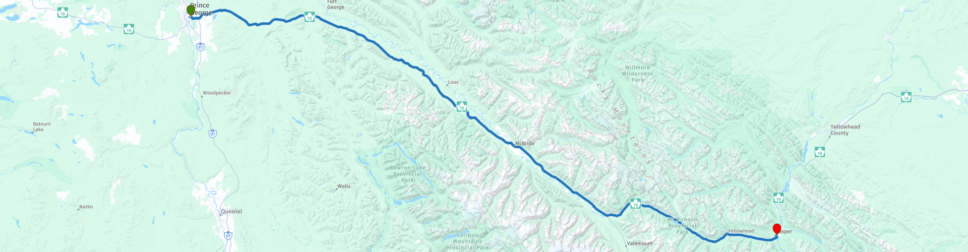
D04 Prince George Jasper

This route was brought to you by:
RouteXpert Hans van de Ven (Mr.MRA)
Last edit: 30-04-2020
 Route Summary
 The roads are very good, the surroundings are very beautiful and a stop in McBride should definitely be done, this is also the only possibility to refuel and eat on the way.
Starting point: Ramada Hotel Prince George
End point: Best Western Jasper Inn & Suites
The route has been made the same for TomTom, Garmin and MyRoute-app Navigation users.
Thanks to Richard & Lisa for the information!
 Share this route


Animation

Verdict


Duration
3h 51m

Mode of travel
Car or motorcycle

Distance
378.90 km

Countries

 RouteXpert Review
 The proximity of these parks and the presence of the Fraser River make the area very suitable for all kinds of outdoor activities. In the late summer and autumn you can see the large salmon stream in the Beaver River. The Horseshoe Lake Bird Viewing Station is a short distance from McBride. Here you can see and photograph birds all year round.
Mount Robson Provincial Park, located west of Jasper National Park in Alberta, is the second oldest park in British Columbia. It owes its name to the 3,954 meter high Mount Robson, the highest peak of the Canadian Rocky Mountains. The park is largely accessible by vehicle, but also partly consists of wilderness
hardly anyone ever comes. The Fraser River, the longest river in British Columbia, has its origins in Mount Robson Park. More than 180 different bird species live in the park. In addition, there are many animals that you often live in
area of the Rockies. In the lower areas you will find mainly black bears, moose and deer, while grizzly bears and mountain goats, for example, roam in higher areas.
The hospitable, picturesque town of Jasper is located in the middle of Jasper National Park, the largest park in the Canadian Rockies. The park consists of glaciers, crystal clear lakes, waterfalls, deep gorges and dense green forests. You will find more than a thousand kilometers of hiking trails. In the winter you have a view of snowy mountain tops and you see frozen waterfalls. Jasper is then a real winter wonderland. However, the park is best known for the many wildlife that live there, including moose, deer and bears.
The Yellowhead Highway crosses Jasper National Park from east to west and together with the Icefields Parkway (which connects to this road from the south) is the most important access road. The Icefields Parkway connects the town of Jasper with the Trans-Canada Highway near Lake Louise and Banff. These major thoroughfares are well paved and accessible to cars and motorhomes. The Mt. Edith Cavell Road is difficult to navigate per camper because of the hairpin bends. Vehicles longer than 7 meters are not permitted here. Due to snowfall, the road is usually between mid-October and the end of June
closed.
The top attraction of Jasper is the Jasper Skytram. The cable car takes you to the 2,277-meter-high Whistlers Mountain, where you can see more than eighty kilometers away in clear weather and get a good idea of the vastness of the park. There are various hiking trails, a souvenir shop and a restaurant on the mountain. Once down again you can opt for the Discovery Trail, an eight-kilometer trip around the city or a visit to one of the museums.
In this 4-star route you will drive on beautiful good roads, through a breathtaking environment and the stop in McBride you should definitely do, you can immediately refuel and have some food and / or drink.
History:
The first people settled in Jasper and the surrounding area more than 10,000 years ago. These were native North Americans who lived from the hunt. David Thompson was the first European to visit the Athabasca Valley, where Jasper is located. From the end of the eighteenth century, he mapped large parts of northwestern Canada for the Hudson's Bay Company and later for the North West Company. He founded some settlements and traded with indigenous tribes.
In 1813, under the authority of the North West Company, Thompson built a storage depot for merchandise on the site of the current town of Jasper. The depot became known as Jasper House, named after Jasper Hawes, the clerk of the North West Company. For more than half a century, Jasper House served as an important stop for all traders who crossed the surrounding mountain passes on foot or by horse and carriage. It was also an important meeting place for travelers, adventurers and explorers.
However, in the course of the nineteenth century, visitors increasingly opted for a new mode of transport: the steamboat. Jasper House closed its doors in 1884. It was demolished in 1909 and the wood was used to make rafts. Just before that, the Jasper Forest Reserve was established by the Canadian government because the activities of the railway company threatened nature in the Athabasca valley. The Reserve protected 13,000 square kilometers of nature and was the precursor to Jasper National Park.
Jasper was founded in 1911 around a new station of the Grand Trunk Pacific Railway. The original name Fitzhugh, after a vice-president of the society, was later changed to Jasper, to match the name of the park. After the expansion of the infrastructure and the arrival of the car, the general public discovered the region. The number of visitors to the national park grew from sporadic visitors in the nineteenth century to the current three million tourists a year.


 Links
Links  Usage
Usage Want to download this route?
You can download the route for free without MyRoute-app account. To do so, open the route and click 'save as'. Want to edit this route?
No problem, start by opening the route. Follow the tutorial and create your personal MyRoute-app account. After registration, your trial starts automatically.  Disclaimer
Use of this GPS route is at your own expense and risk. The route has been carefully composed and checked by a MyRoute-app accredited RouteXpert for use on TomTom, Garmin and MyRoute-app Navigation.
Changes may nevertheless have occurred due to changed circumstances, road diversions or seasonal closures. We therefore recommend checking each route before use.
Preferably use the route track in your navigation system. More information about the use of MyRoute-app can be found on the website under 'Community' or 'Academy'.