Day 05 TCH Revelstoke to Lake Louise

This route was brought to you by:
RouteXpert René Plücken (MRA Master)
Last edit: 12-02-2021
 Route Summary
 This is part 5 that runs from Revelstoke to Lake Louise.
The Trans Canada Highway passes through all the southern provinces of the country. The route can be driven in different ways. There are namely in various alternative routes that also belong to the TCH. The total distance is around 8,000 km. We not only drive the TCH, but will take the rural roads as much as possible, because only highway driving is too boring and Canada has many beautiful roads through its beautiful landscape.
You drive through all provinces and through very varied and scenic landscapes, from the Rockies in the West, the Central Prairies to the Eastern Maritimes and the Northern Forest.
The riding season is generally April through October with longer seasons on the west coast and southern Ontario.
Provide good all season clothing or bring rain gear, depending on the province and the season the weather can change and you may be surprised by a rain or even a snow or hail shower, so be prepared.
In Canada the metric system is used, so speeds are indicated in Km / h. A helmet requirement (DOT approved) applies throughout Canada.
You will see many wildlife throughout Canada. your similar animals from province to province, such as deer, buffalos, moose, caribou, wolves, pumas, bears, mountain goats, sheep, lynx, coyotes, foxes, raccoons, badgers, various rodents and all kinds of birds.
Even if it is very tempting to stop for a photo, don't do it, it can be very dangerous.
 Share this route


Animation

Verdict


Duration
5h 3m

Mode of travel
Car or motorcycle

Distance
291.23 km

Countries

 RouteXpert Review
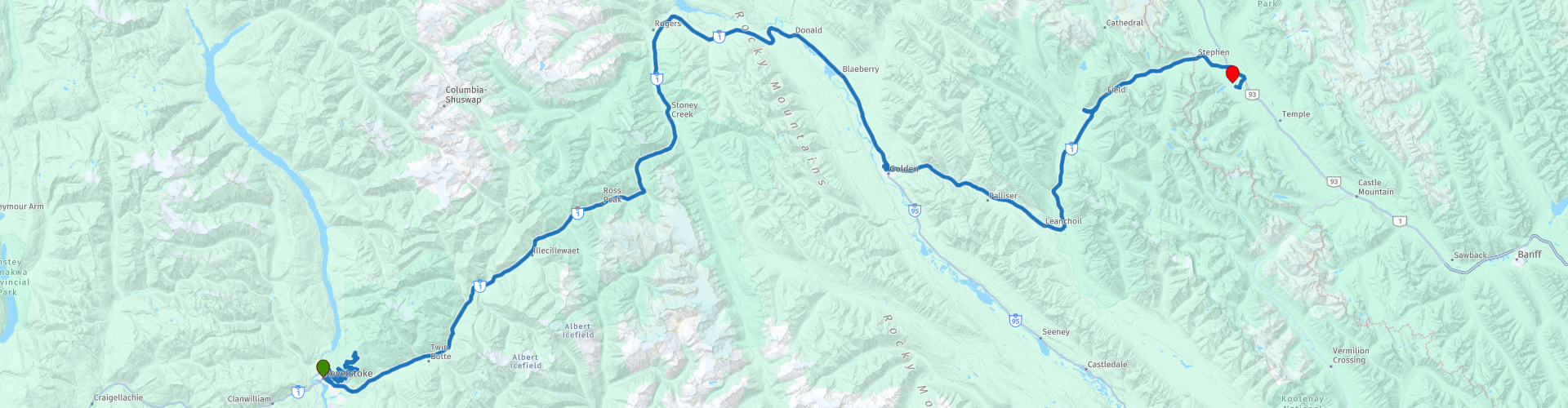
 We descend the same road again, so enjoy the beautiful winding roads and panoramas again. We turn into the TCH with the Revelstoke National Park on the left and the Illecillewaet River on the right. Along the route are a number of sights and a number of Boardwalks, wooden hiking trails through the National Park. So for lovers of walking through nature, a number are included as a route point;
RP6 Skunk Cabbage Boardwalk Trail is a 1.2 km loop course that has a river and is good for all levels. The path is mainly used for hiking, walking, nature trips and bird watching and is best used from June to October.
RP7 Giant Cedars Boardwalk a 0.5 kilometer walkway through old cedar and hemlock woods, on the east side of Mount Revelstoke National Park. It is generally busier than the Hemlock Grove Trail, perhaps because the trees along this promenade seem nicer.
RP10 Hemlock Grove Boardwalk is a 0.5 kilometer long boardwalk through old green cedar and hemlock forest, on the west side of Glacier National Park. This is generally less crowded than the other Boardwalks.
RP11 Rockgarden Trail is a 0.5-kilometer walking route below Cougar Mountain, on the west side of Canada's Glacier National Park. It is a beautiful nature trail with beautiful views of the surrounding mountains on clear days.
RP12 Loop Brook Trail is a 1.6 kilometer long, lightly traded loop trail near Columbia-Shuswap A, British Columbia, Canada, which has a lake and is good for all levels. The path is mainly used for hiking, walking and nature trips.
At RP 13 we arrive at the Rogers Pass, a narrow valley surrounded by a number of mountains. It is formed by the headwaters of the Illecillewaet River in the west and by the Beaver River in the east. Both rivers are tributaries of the Columbia River. More information about the Rogers Pass and the surrounding area is given at Rogers Pass Discovery Center (RP14), a replica of a historic railroad shed. Explore Magazine calls it "the best national park museum in Canada". This recently renovated information center features a theater, exhibitions about avalanches, wildlife and the history of the area. The Discovery Center is the only facility that is open in early spring and winter.
In Golden (RP16) we stop for lunch and to possibly refuel. There are several restaurants here.
At RP19 you can visit the beautiful Natural Bridge in Kicking Horse River, this is an impressive rock formation that has taken on the shape of a bridge completely naturally over the years. Because of the enormous power of the Kicking Horse River this bridge is worn out. It is very special to see how enormously strong water can be and what it can create. Surrounded by mountains and pine trees, you look at your eyes here. You can walk along the banks of the river and stay surprised by the beauty of it.
At RP21 you will find the Kicking Horse Pass National Historic Site. Look in surprise from the vantage points along the Trans-Canada Highway as trains enter the Spiral Tunnels corkscrew and appear on higher or lower points on Rocky Mountain slopes. Read more about the role that Kicking Horse Pass played in connecting Canada from coast to coast in 1885 by rail. Discover Field elk on the river flats, explore the local railroad or organize a tour of the famous fossil banks of Burgess Shale.
After this it is just over 20 kilometers to the end point of this route is at Lake Louise.
This fifth leg of the Trans Canada Highway is worth 4 **** stars, it is a beautiful ride with beautiful views and there are a number of activities and sights along the way.


 Links
Links  Usage
Usage Want to download this route?
You can download the route for free without MyRoute-app account. To do so, open the route and click 'save as'. Want to edit this route?
No problem, start by opening the route. Follow the tutorial and create your personal MyRoute-app account. After registration, your trial starts automatically.  Disclaimer
Use of this GPS route is at your own expense and risk. The route has been carefully composed and checked by a MyRoute-app accredited RouteXpert for use on TomTom, Garmin and MyRoute-app Navigation.
Changes may nevertheless have occurred due to changed circumstances, road diversions or seasonal closures. We therefore recommend checking each route before use.
Preferably use the route track in your navigation system. More information about the use of MyRoute-app can be found on the website under 'Community' or 'Academy'.