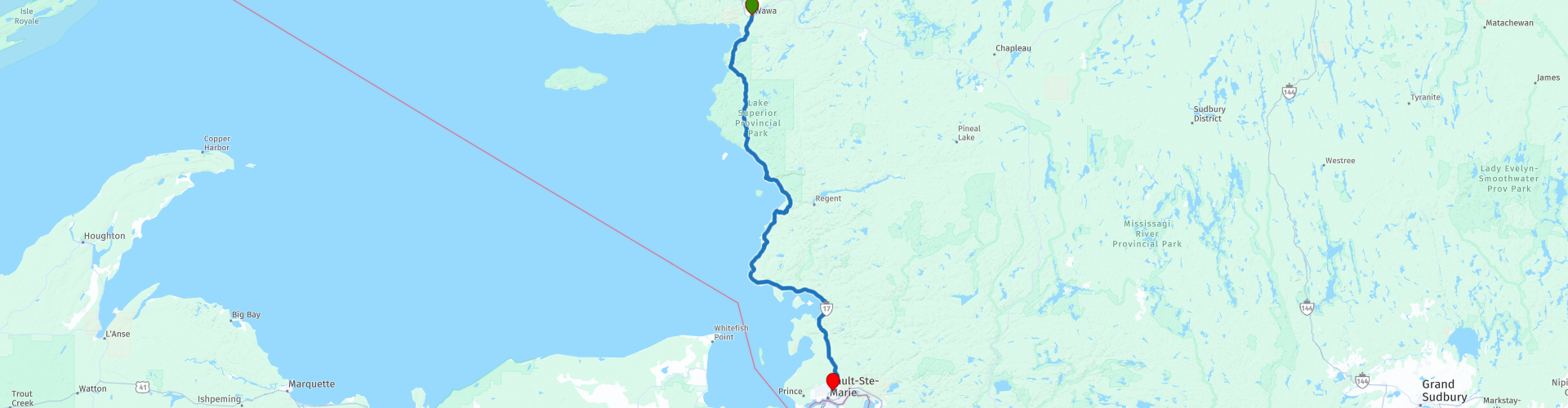
Day 17 TCH Wawa to Sault Ste Marie

This route was brought to you by:
RouteXpert René Plücken (MRA Master)
Last edit: 09-11-2025
 Route Summary
 This is section 17 which runs from Wawa to Sault Ste Marie.
The Trans-Canada Highway passes through all of the country's southern provinces. The route can be driven in various ways, as there are several alternative routes that also belong to the Trans-Canada Highway. The total distance is around 8,000 km. We won't be driving solely the Trans-Canada Highway, but will be taking as much of the country's back roads as possible, as highway driving alone is too boring, and Canada boasts many beautiful roads through its stunning landscape.
You'll drive through all the provinces and through very diverse and picturesque landscapes, from the Rockies in the west, the Central Prairies to the eastern Maritimes and the northern forest.
The riding season is generally from April to October with longer seasons on the west coast and southern Ontario.
Make sure you have good all-season clothing or bring rain gear. Depending on the province and the season, the weather can change suddenly and you might be surprised by a rain shower, or even a snow or hail shower, so be prepared.
In Canada, the metric system is used, so speeds are indicated in km/h. Helmets are mandatory throughout Canada (DOT approved).
Throughout Canada, you'll see plenty of wildlife. Similar animals vary from province to province, including deer, buffalo, moose, caribou, wolves, cougars, bears, mountain goats, sheep, lynx, coyotes, foxes, raccoons, badgers, various rodents, and a variety of birds.
Even though it is very tempting to stop for a photo, don't do it, it can be very dangerous.
This is a fantastic ride that deserves a solid 5*****. It has a lot to offer and is enjoyable from start to finish, with several stops planned along the way. We'll ride through a beautiful nature park, and for those who enjoy it, this day can be extended with one or two extra days to enjoy all the beauty this park has to offer.
 Share this route


Animation

Verdict


Duration
8h 50m

Mode of travel
Car or motorcycle

Distance
226.08 km

Countries

 RouteXpert Review
 Today's itinerary features a ride that has it all: nature, culture, and endless views. We'll drive through the impressive Lake Superior Provincial Park, an area with so much to offer that you could easily spend an extra day (or two).
Before leaving Wawa, we fill up the tank and stock up on snacks and drinks. After about 15 kilometers, we reach the entrance to Lake Superior Provincial Park. With its 1,550 km² of wilderness, it's one of Ontario's largest provincial parks. Cliffs, beaches, river valleys, waterfalls, and countless inland lakes create a landscape you won't soon forget. Everything is well-marked with brown and yellow signs, and for those who want to, you can hike, canoe, fish, or even camp at one of the 200 backcountry campsites.
Our must-stops in the park:
• Old Woman Bay, a long sandy beach surrounded by 200-meter-high cliffs. The view of Entrance Island and the open water of Lake Superior is breathtaking. Perfect for a picnic or a photo.
• Katherine Cove, an idyllic cove with a small beach and clear water. A place to pause and enjoy.
• Agawa Rock Pictographs, one of Canada's most famous archaeological sites. Here you'll see ancient Ojibwe rock paintings, dream stories, and visions. Respect this sacred place; don't touch, just admire.
• Agawa Bay Scenic Lookout, A panoramic view of the bay, ideal for a photo.
• Visitors Centre, For additional information about the park and a view of Montreal Island.
• Montreal River Dam, A short detour for a photo of one of the four hydroelectric dams on the river.
Halfway through, we'll have lunch at Northgate Chip Wagon Plus, with delicious home-made meals, but note: cash only!
After lunch, the road winds further along the coastline. Through the trees, you'll catch glimpses of Lake Superior and its bays: Mica Bay, Flour Bay, and Cottrell Cove.
At Pancake Bay, you can fill up your tank, grab a drink, and perhaps sample a piece of fresh trout. There's also a souvenir shop.
For those who want to relax on the beach, Batchawana Bay Provincial Park offers a beautiful sandy beach.
Our last stop is at Chippewa Falls, not a high waterfall, but a long, wide stream that winds its way to the bay. On the other side, you'll find a restaurant and a souvenir shop.
Then it's another 50 kilometers of enjoying rocks, forests, and views over Batchawana Bay until we arrive in Sault Ste. Marie, a city full of history and nature.
My rating: ★★★★★, Five stars for a stage that has it all: spectacular scenery, cultural history, and a road that surprises you again and again. Take your time, stop often, and savor every kilometer.
Enjoy the Ride!


 Links
Links  Usage
Usage Want to download this route?
You can download the route for free without MyRoute-app account. To do so, open the route and click 'save as'. Want to edit this route?
No problem, start by opening the route. Follow the tutorial and create your personal MyRoute-app account. After registration, your trial starts automatically.  Disclaimer
Use of this GPS route is at your own expense and risk. The route has been carefully composed and checked by a MyRoute-app accredited RouteXpert for use on TomTom, Garmin and MyRoute-app Navigation.
Changes may nevertheless have occurred due to changed circumstances, road diversions or seasonal closures. We therefore recommend checking each route before use.
Preferably use the route track in your navigation system. More information about the use of MyRoute-app can be found on the website under 'Community' or 'Academy'.