Day 22 TCH Montreal to Quebec

This route was brought to you by:
RouteXpert René Plücken (MRA Master)
Last edit: 16-11-2025
 Route Summary
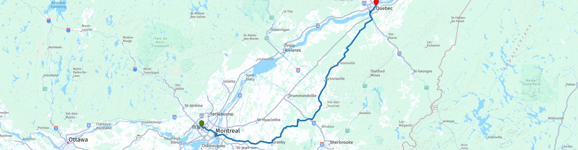
 This is section 22 which runs from Montreal to Quebec.
The Trans-Canada Highway passes through all of the country's southern provinces. The route can be driven in various ways, as there are several alternative routes that also belong to the Trans-Canada Highway. The total distance is around 8,000 km. We won't be driving solely the Trans-Canada Highway, but will be taking as much of the country's back roads as possible, as highway driving alone is too boring, and Canada boasts many beautiful roads through its stunning landscape.
You'll drive through all the provinces and through very diverse and picturesque landscapes, from the Rockies in the west, the Central Prairies to the eastern Maritimes and the northern forest.
The riding season is generally from April to October with longer seasons on the west coast and southern Ontario.
Make sure you have good all-season clothing or bring rain gear. Depending on the province and the season, the weather can change suddenly and you might be surprised by a rain shower, or even a snow or hail shower, so be prepared.
In Canada, the metric system is used, so speeds are indicated in km/h. Helmets are mandatory throughout Canada (DOT approved).
Throughout Canada, you'll see plenty of wildlife. Similar animals vary from province to province, including deer, buffalo, moose, caribou, wolves, cougars, bears, mountain goats, sheep, lynx, coyotes, foxes, raccoons, badgers, various rodents, and a variety of birds.
Even though it is very tempting to stop for a photo, don't do it, it can be very dangerous.
This 5***** Star trip has a lot to offer along the way and you drive on beautiful roads through a beautiful green landscape.
 Share this route


Animation

Verdict


Duration
9h 8m

Mode of travel
Car or motorcycle

Distance
337.12 km

Countries

 RouteXpert Review
 Today we're not taking a highway, but a route full of charm and variety. Instead of the straight Autoroutes QC-20 or QC-40, we're opting for provincial roads that take us through the Quebec countryside, past rivers, villages, and historic sites. This drive is a treat for those who enjoy variety.
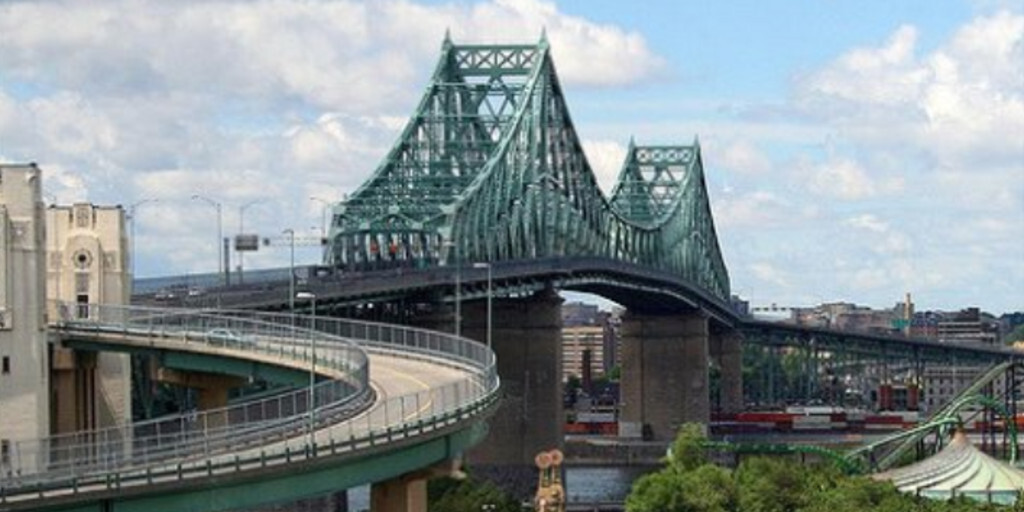
We leave Montreal via the Jacques Cartier Bridge, an imposing steel structure spanning the Saint Lawrence River. Halfway there, you can turn off to Île Sainte Hélène for a visit to Parc Jean-Drapeau, La Ronde amusement park, or the Stewart Military Museum.
The island is also home to The Biosphere, a futuristic geodesic dome designed by Buckminster Fuller. This museum about the environment and sustainability is an architectural icon.
We cross a bridge to Île Notre-Dame, famous for the Circuit Gilles Villeneuve. Outside of race weekends, you can cycle, skate, or even take a drive on the official F1 circuit, featuring the Wall of Champions: the infamous chicane where champions crashed, and the Start/Finish line: along the pit lane, a must-see for motorsport fans.
We'll cross the historic Pont Victoria, a 3-kilometer-long bridge with 24 icebreaking piers. An impressive feat of engineering. If it's safe to do so, you can stop for a photo.
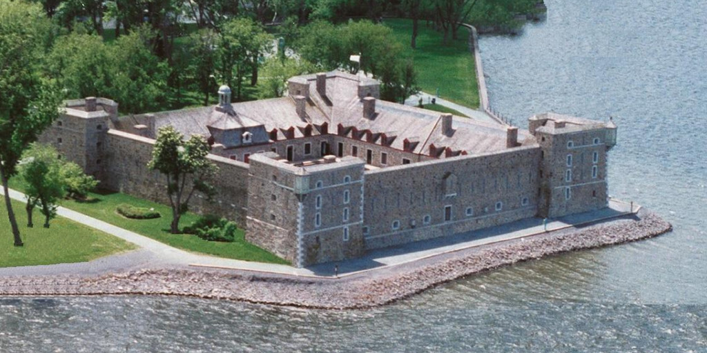
In Chambly, you'll find plenty of restaurants for a lunch break. After lunch, we'll visit Fort Chambly, a National Historic Heritage Site. This stone fort, dating from 1711, guards the Richelieu Rapids and tells stories from the New France era.
We follow the QC-122 through the Quebec countryside, past green meadows and the mountains of Mont Rougemont and Mont Yamaska. In Granby, you can visit the zoo and water park. Then we wind along the QC-139 through a landscape of forests, lakes, and villages. Stop at Roxton Falls for a photo of the waterfall.
We reach Richmond via QC-222 and QC-116, where we cross the MacKenzie Bridge. This narrow steel lattice bridge is an experience in itself, especially in the rain!
We continue on QC-116 until we reach the imposing Pont de Québec. At 987 meters long and 104 meters high, it's the longest cantilever bridge in the world. On the other side is the Aquarium du Québec, where you can admire walruses, seals, and thousands of marine animals.
We drive along Boulevard Champlain, following the Saint Lawrence River to downtown Quebec. This city is a true gem; definitely plan an extra day to explore everything.
My rating: ★★★★★. A journey full of contrasts: from F1 circuits to historic forts, from green valleys to iconic bridges. This is Quebec at its finest.
 Links
Links  Usage
Usage Want to download this route?
You can download the route for free without MyRoute-app account. To do so, open the route and click 'save as'. Want to edit this route?
No problem, start by opening the route. Follow the tutorial and create your personal MyRoute-app account. After registration, your trial starts automatically.  Disclaimer
Use of this GPS route is at your own expense and risk. The route has been carefully composed and checked by a MyRoute-app accredited RouteXpert for use on TomTom, Garmin and MyRoute-app Navigation.
Changes may nevertheless have occurred due to changed circumstances, road diversions or seasonal closures. We therefore recommend checking each route before use.
Preferably use the route track in your navigation system. More information about the use of MyRoute-app can be found on the website under 'Community' or 'Academy'.