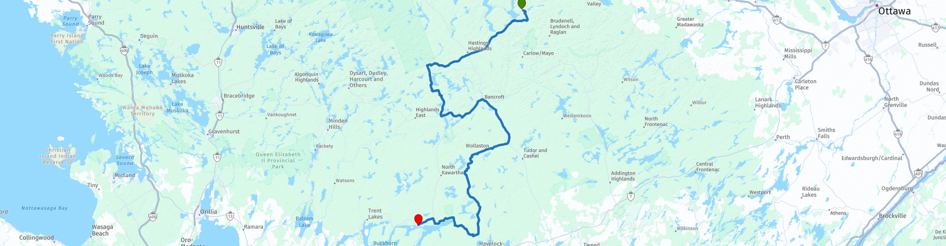
Barrys Bay to Burleigh Falls via Bancroft Ontario

This route was brought to you by:
RouteXpert William Edward Henry
Last edit: 14-10-2021
 Route Summary
 We start at Hush Lodge just south of Barry's Bay and finish at Burleigh Falls where there is good overnight accommodation available.
Along this route, there are lots of opportunities to get off the bike at scenic lookouts and historic towns.
The stunning scenery includes a multitude of pristine lakes and twisty roads on the way to Burleigh Falls.
We have scheduled a lunch stop at the motorcycle-friendly Hideaway Grill in Coe Hill.
If you have time and inclination, the Petroglyphs Provincial Park is an optional stop on the route.
The route ends at Burleigh Falls where accommodation and refreshment await.
I rate this route as four-plus stars. The scenery, roads, and amenities make this a great ride.
 Share this route


Animation

Verdict


Duration
5h 52m

Mode of travel
Car or motorcycle

Distance
256.48 km

Countries

 RouteXpert Review
 There are approximately 250,000 freshwater lakes in Ontario. Together, they contain about a fifth of the world's freshwater supply. On this route, you will see a few dozen of them while you negotiate twisty challenging roads through the scenic beauty of this province.
On leaving Hush Lodge just south of Barry's Bay, we head south through the village of Combermere. There are convenient stops in town where a simple breakfast can be had. The proprietors at Hush Lodge are motorcycle enthusiasts and readily offer advice on the best spots for breakfast.
A short distance west of Combermere is the Lake Kamaniskeg lookout. It is accessed via a short uphill road that requires some care as the surface is loose in places.
At the lookout, you're rewarded with a grand view of this beautiful lake and the location of the sunken ferry "Mayflower". The foundering of the "Mayflower" is Canada's worst inland maritime disaster; almost all on board lost their lives in the sinking. By a strange quirk of fate, a few were saved by clinging to a coffin while drifting to a nearby island. The historical plaque at this lookout relates the story.
On our way again to the town of Bancroft, we ride on some of the best motorcycle roads in Ontario. When passing through Bancroft, a visit to the visitor information centre located in the old train station will provide additional information on attractions in the area.
It will be about time for a break and lunch when you approach the Hideaway Primitive Grill in Coe Hill. This is a motorcycle friendly restaurant with both an indoor dining area and outside deck. There is a relaxing pastoral view from the deck out over the surrounding countryside.
After leaving Coe Hill, you will find Petroglyphs Provincial Park. It houses a large collection of Indigenous rock carvings (petroglyphs) believed to be approximatley 1,000 years old. The site is also a Canadian National Historic Site.
The spectacular route ends in Burleigh Falls. Time to relax and reflect on a new set of memories.


 Links
Links  Usage
Usage Want to download this route?
You can download the route for free without MyRoute-app account. To do so, open the route and click 'save as'. Want to edit this route?
No problem, start by opening the route. Follow the tutorial and create your personal MyRoute-app account. After registration, your trial starts automatically.  Disclaimer
Use of this GPS route is at your own expense and risk. The route has been carefully composed and checked by a MyRoute-app accredited RouteXpert for use on TomTom, Garmin and MyRoute-app Navigation.
Changes may nevertheless have occurred due to changed circumstances, road diversions or seasonal closures. We therefore recommend checking each route before use.
Preferably use the route track in your navigation system. More information about the use of MyRoute-app can be found on the website under 'Community' or 'Academy'.