Roundtrip Schonach im Schwarzwald to Titisee

This route was brought to you by:
RouteXpert Arno van Lochem - Senior RX
Last edit: 30-10-2021
 Route Summary
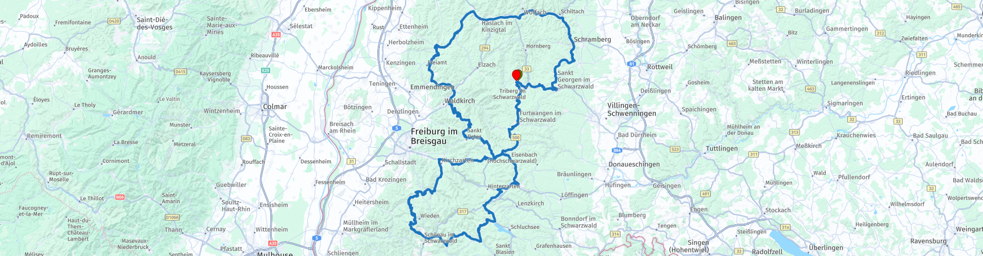
 With an area of nearly 10,000 km2 and heights of up to 1500m, beautiful roads must be constructed. And it is! This route covers part of it.
This route runs from Schonach im Schwarzwald on beautiful roads with even better views towards the south of the Black Forest towards the Titisee, the Schluchsee and the Windgfällweiher. All beautiful lakes that are definitely worth a visit. Be surprised by all the beauty that the Black Forest has to offer.
 Share this route


Animation

Verdict


Duration
5h 27m

Mode of travel
Car or motorcycle

Distance
295.53 km

Countries

 RouteXpert Review
 From Schonach im Schwarzwald the route runs along Triberg, where there is the possibility to visit the waterfalls. With a drop height of 163m, these are among the highest waterfalls in Germany. Definitely worth a visit. This can be done on the road, but also in the evening after a walk from the hotel.
Further in the town of Schramberg, three museums are a stone's throw away from each other: the Steim car collection, the Diesel museum and the Auto and Clock World museum.
The Steim car collection is the collection of a real car collector, open to the public. The cars are in pristine condition with good information signs. The layout of the museum over 2 floors makes it easy for everyone to see everything from the vehicles. Some real rarities.
The diesel museum is the second museum and can be visited free of charge. Here you will find, among other things, the giant diesel generator that was supposed to supply the factories there at the time. In addition, there are also some steam powered models from before 1900.
Finally, the Auto & Uhren Museum. More than 200 cars and two-wheelers need a lot of space to be exhibited. And there is a lot of space in the monumental industrial building of the Hamburg-Amerikanischen-Uhrenfabrik (HAU)! The 'vehicle worlds and post-war time story' of the Martin Sauter collection is spread over four floors. The watch museum is located on the fifth, also top floor.
All three museums are definitely worth a visit!
At RP9 it is possible to stop at the Gaisfelsenhütte. This viewpoint built in 1927 is located on the L186, via which the 1241m high Kandel is reached. But one thing is certain, the view from this cabin is breathtaking!
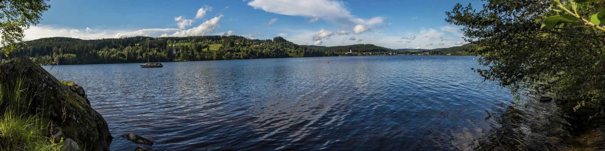
The lake in the title of this route, the Titisee, is one of the better known lakes in the southern Black Forest. The Titisee is a lake with an area of 1.3 km² and has an average depth of 20m. Although they are large dimensions, it is certainly not the largest lake in this area. Nevertheless, many tourists come every year. There is always plenty to do at the lake. The most popular activity is a walk around the lake. The nearby mountain Hoch offers an observation tower at an altitude of 1,192 meters. A hike from the lake to this point is also highly recommended. Cycling in the region is a popular choice, although this requires considerable effort because of the height differences. It is also good to stay on the water. For example, it is possible to take a boat trip, in a large tour boat or, for example, in a pedal boat. Swimming in the lake is possible, but there are also swimming pools around the lake.
Once in Feldberg, the Schnaps Museum can be visited. Lovers of vintage motorbikes and all kinds of schnapps will get their money's worth here: the schnapps museum in Café zum Gscheiten Beck introduces you to the art of distilling schnapps and offers guided tours with tasting.
Prefer something sweet? That is also possible, in the café delicious homemade cakes are available.
A few kilometers away, the route runs along the Windgfällweiher. This lake was dammed to its present size in 1895. The current size is 700 m long and 400 m wide. Some of the water from the Feldsee flows through the Windgfällweiher before reaching the Schluchsee.
Shortly after the Windgfällweiher it is possible to stop at the Schluchsee. The Schluchsee is a reservoir near St. Blasien in the Breisgau-Hochschwarzwald district in the German state of Baden-Württemberg. It is the largest lake in the Black Forest. The 63-meter-high dam on the other side was erected from high-density concrete between 1929 and 1932. It is possible to make a 75-minute cruise on the reservoir with the MS Schluchsee. For more information, see the link below.
After these three lakes, it is high time to enjoy the beautiful curves again, of which fortunately a lot have been built. In addition, the route runs over a number of 'highlights' of the Black Forest, including the Äulemer Kreuz (1138m), the Wacht (973m) and the Wiedener Eck (1035m).
At RP21 there is a viewpoint where you can stop for a while, the Lusthäusle. This viewpoint offers a beautiful view over the valley between the surrounding mountains. Great ingredients for beautiful photos!
The Steinwasen summer toboggan run that the route passes by is definitely worth a visit. The park has several toboggan runs, it also has the longest suspension bridge in the world. Just stop here to see what kind of violence comes rushing down the mountain.
Have fun on this tour!


 Links
Links  Usage
Usage Want to download this route?
You can download the route for free without MyRoute-app account. To do so, open the route and click 'save as'. Want to edit this route?
No problem, start by opening the route. Follow the tutorial and create your personal MyRoute-app account. After registration, your trial starts automatically.  Disclaimer
Use of this GPS route is at your own expense and risk. The route has been carefully composed and checked by a MyRoute-app accredited RouteXpert for use on TomTom, Garmin and MyRoute-app Navigation.
Changes may nevertheless have occurred due to changed circumstances, road diversions or seasonal closures. We therefore recommend checking each route before use.
Preferably use the route track in your navigation system. More information about the use of MyRoute-app can be found on the website under 'Community' or 'Academy'.