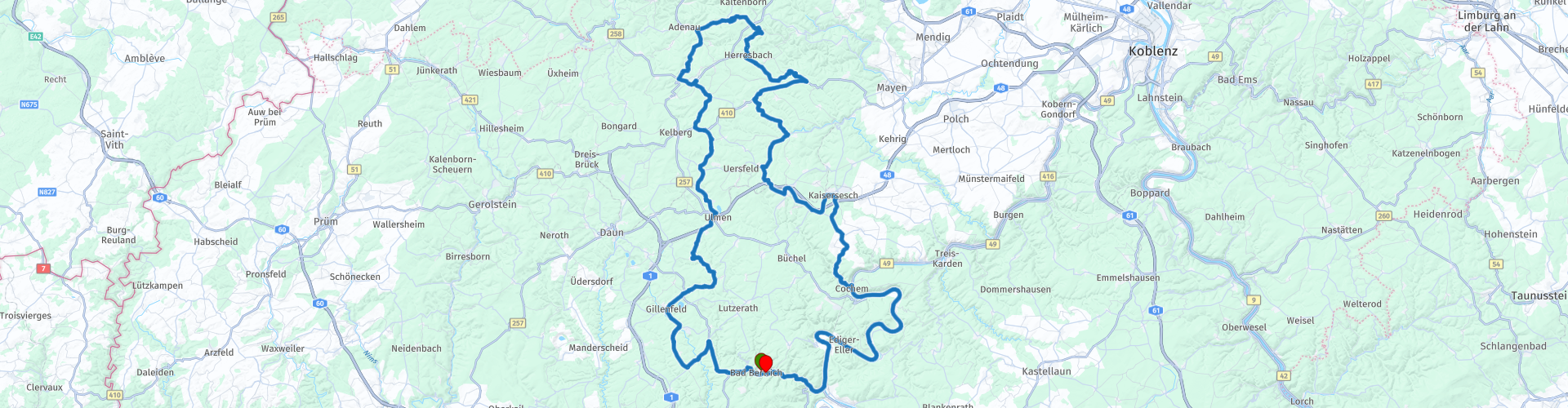
Bad Bertrich Nurburgring

This route was brought to you by:
RouteXpert Gerard Martens Route Expert
Last edit: 13-02-2019
 Route Summary
 With a main visit to the info center / main stand of the Nurburgring.
Then a pit stop in Adenau along the Nordschleife, here you can stand along the track.
On this route we pass the ruins of Virneburg.
And finally we can take a terrace in Cochem.
 Share this route


Animation

Verdict


Duration
3h 4m

Mode of travel
Car or motorcycle

Distance
166.23 km

Countries

 RouteXpert Review
 After about an hour through beautiful curves and forests, we arrive at the Nürburgring. The Nürburgring is a race circuit in Nürburg, in the German state of Rhineland-Palatinate. On September 27, 1925 began the construction of the circuit around the village and the medieval castle Nürburg in the Eifel. The opening was on the weekend of 18 and 19 June 1927. The circuit is nicknamed 'The Green Hell'. Previously, the course took the riders over 28 km. It then consisted of the Nordschleife (22.8 km) and Südschleife (7.7 km). The Nürburgring Nordschleife is part of the old Nürburgring. 21 Grands Prix were held between 1951 and 1976. The former Nürburgring, which was only 20.8 km long, had killed five Formula 1 drivers at Grand Prix competitions and caused many others to suffer permanent injuries. The enormous circuit was built as a job-creation project in the 1920s around the village of Nürburg in the Eifel mountains to the southwest of Bonn. It officially contained 176 bends spread over the 20.8 km of the Nordschleife and 7.7 km of the separate Südschleife. The bends are known as Flugplatz, Aremberg, Bergwerk, Karussel and Pflanzgarten. There is plenty to see at the main stand of the circuit, there are old formula 1 cars and there are shops selling all kinds of stuff that have to do with racing or the Nürburgring. We drive on and arrive at Adenau, here you can watch the cars and motorcycles racing at the Nordschleife. We drive a bit along with the track and then go to the south at Herresbach. At Virneburg you can view The castle ruins of Virneburg, it is the ruin of a castle on the hill. Arrived at our next resting point the tourist town Cochem, Cochem is a town on the Mosel in Germany. It is located in the Land Rhineland-Palatinate. It is the Kreisstadt of the Landkreis Cochem-Zell. The city is a tourist town dominated by the mountain lock.
The Cochem castle was built in the 12th and 13th centuries and served as a protection for the city and the Mosel.
We continue our route and drive a bit further along the Moselle.
At Alf we go back to Bad Bertrich, back to our Hotel.
I appreciate this route with 5 stars nice curves and enough to do during this route.
This route has been adapted for MRA Navigation / Garmin and TomTom.


 Links
Links  Usage
Usage Want to download this route?
You can download the route for free without MyRoute-app account. To do so, open the route and click 'save as'. Want to edit this route?
No problem, start by opening the route. Follow the tutorial and create your personal MyRoute-app account. After registration, your trial starts automatically.  Disclaimer
Use of this GPS route is at your own expense and risk. The route has been carefully composed and checked by a MyRoute-app accredited RouteXpert for use on TomTom, Garmin and MyRoute-app Navigation.
Changes may nevertheless have occurred due to changed circumstances, road diversions or seasonal closures. We therefore recommend checking each route before use.
Preferably use the route track in your navigation system. More information about the use of MyRoute-app can be found on the website under 'Community' or 'Academy'.

Rheinland Pfalz
About this region
Rhineland-Palatinate (German: Rheinland-Pfalz, [ˈʁaɪ̯nlant ˈp͡falt͡s] (listen)) is a western state of Germany. It covers 19,846 km2 (7,663 sq mi) and has about 4.05 million residents. It is the ninth largest and sixth most populous of the sixteen states. Mainz is the capital and largest city. Other cities are Ludwigshafen am Rhein, Koblenz, Trier, Kaiserslautern and Worms. It is bordered by North Rhine-Westphalia, Saarland, Baden-Württemberg and Hesse and by the countries France, Luxembourg and Belgium.
Rhineland-Palatinate was established in 1946 after World War II, from parts of the former states of Prussia (part of its Rhineland province), Hesse and Bavaria (its former outlying Palatinate kreis or district), by the French military administration in Allied-occupied Germany. Rhineland-Palatinate became part of the Federal Republic of Germany in 1949 and shared the country's only border with the Saar Protectorate until the latter was returned to German control in 1957. Rhineland-Palatinate's natural and cultural heritage includes the extensive Palatinate winegrowing region, picturesque landscapes, and many castles and palaces.
Read more on Wikipedia
Rhineland-Palatinate was established in 1946 after World War II, from parts of the former states of Prussia (part of its Rhineland province), Hesse and Bavaria (its former outlying Palatinate kreis or district), by the French military administration in Allied-occupied Germany. Rhineland-Palatinate became part of the Federal Republic of Germany in 1949 and shared the country's only border with the Saar Protectorate until the latter was returned to German control in 1957. Rhineland-Palatinate's natural and cultural heritage includes the extensive Palatinate winegrowing region, picturesque landscapes, and many castles and palaces.
View region
 Statistics
  141
141Amount of RX reviews (Rheinland Pfalz)
 51800
51800Amount of visitors (Rheinland Pfalz)
 28887
28887Amount of downloads (Rheinland Pfalz)
 Route Collections in this region
 Top 5 Car and Motorcycle Routes in the Eifel
The Eifel is the eastern part of the medium plateau Eifel-Ardennes. It is located north of the Moselle and west of the Rhine. The largest part is in Germany, a small part is in Belgium, in the East Cantons. The German part of Eifel is located in the federal states of North Rhine-Westphalia and Rhineland-Palatinate. The highest point is the Hohe Acht with 747 meters.
Several chains can be distinguished in the Eifel:
The northernmost part is called the Nordeifel, which in Belgium connects to the High Fens;
To the east of this is the Ahrgebirge, this part is located north of the Ahr in the Ahrweiler district;
South of the Ahr is the Hohe Eifel (or Hocheifel), of which the Hohe Acht (747 m) is the highest point, and also the highest point in the entire Eifel region;
To the west, near the Belgian border, the hills are known as Schneifel, part of the wider Snow Eifel area with peaks reaching up to 698 metres;
South and east of the Hohe Eifel is the Volcano-Eifel, a volcanic area with many crater lakes (Maare).
The southern part of the Eifel is less high. The area is bisected by streams and rivers running southwards. These streams flow into the Moselle. The largest of these rivers is the Kyll; the hills around this river are known as the Kyllwald;
In the south, the Eifel ends in the Voreifel.
In the north of the Eifel there are some large reservoirs. The largest of these is the reservoir in the Roer that was created by the construction of the Roerdal dam.
The Nürburgring is also located in the Eifel, a well-known car circuit for Formula 1 races, among other things. Since 2004, part of the north of the Eifel has become the Eifel National Park. This National Park falls entirely within the German-Belgian nature park High Fens-Eifel. Another part of the Eifel falls within the South Eifel Nature Park.
Well-known throughout the Netherlands and Belgium by car and motorcyclists, so reason enough for the MyRoute app RouteXpert to compile a Top 5 of Car and Motorbike routes for you.
All routes in this collection have been checked and made equal for TomTom, Garmin and MyRoute-app Navigation by a MyRoute-app RouteXpert.
If you think, I have a very nice route that should certainly not be missing from this collection, send it to:
email: routeexpert@myrouteapp.com
Subject: New Route for the Top 5 collection Eifel composed by Hans van de Ven.
The route will then be reviewed and then added to the Top 5. To make the Top 5 also the Top 5, 1 route will have to disappear from the Top 5, you can indicate this when submitting the new route.
Have fun with this collection and while driving one of these routes. Enjoy all the beauty that the Eifel has to offer. Click on “View route” to read the review of the chosen route.
I would like to hear your findings about the route(s).
View Route Collection
Route collection hairpins in the Eifel
This collection is composed of the most beautiful and winding roads in the Eifel. Forget Bundesstraßen, forget the road along the Moselle, if you have driven these roads, you can really say that you have been to the Eifel.
No less than 6 routes and 1,800 kilometers are waiting for you!
No less than 6 routes and 1,800 kilometers are waiting for you!
View Route Collection