
Roundtrip La Gomera Canary Islands

This route was brought to you by:
RouteXpert René Plücken (MRA Master)
Last edit: 20-08-2025
 Route Summary
 Located just 30 kilometres (50 minutes by boat) from Tenerife, La Gomera is the second smallest island in the Canary Islands archipelago.
On this island you can observe nature in its purest state, as here you will find lush forests, huge gorges and cliffs of unimaginable shapes.
This route was created with the help of Luca from Canary Island Rides, who has often ridden this route as a guide for guided motorcycle tours and also rents out motorcycles. I rate this route 5 stars because of the beautiful scenery and the wonderful roads.
 Share this route


Animation

Verdict


Duration
5h 33m

Mode of travel
Car or motorcycle

Distance
128.56 km

Countries

 RouteXpert Review
 The tour starts and ends in Tenerife, in Playa de las Américas, at the motorcycle rental company Canary Island Rides. They are an independent Harley-Davidson motorcycle rental company (various models available). They also offer guided tours where an experienced rider accompanies you all day, showing you the most beautiful roads and spots in La Gomera.
Don't have a driver's license but still want to enjoy this motorcycle ride? No problem! The guide will be happy to take you along as a passenger. Motorcycle rental prices include the necessary insurance and unlimited mileage, helmets, jackets, and gloves. The motorcycles are often equipped with a mobile phone holder, so you can ride this route with MyRouteApp. However, it's advisable to bring a power bank, as USB ports aren't always available on rental motorcycles.
The route is approximately 130 kilometers and will take all day due to the many stops along the way. Allow plenty of time so you don't miss the ferry back. We'll first drive to the port to catch the ferry to La Gomera (this is not included in the itinerary). The crossing takes approximately 50 minutes.
La Gomera is a rugged, mountainous island with a coastline dominated by impressive cliffs. La Gomera has few beaches, and the interior is covered with deep, often verdant valleys and ravines. The authentic landscape, particularly in the north and west of the island, is dominated by terraced fields where potatoes, corn, bananas, tomatoes, grapes, and dates are grown.
At the center of the island lies the El Alto Garajonay mountain, and we drive through the surrounding Garajonay National Park, with its laurel forests, ravines, streams, and steep mountain ridges. It's a place where nature still reigns supreme. There are many ups and downs, and the roads have numerous (hairpin) bends. Driving experience is therefore required.
The roads are of good quality, clean, and generally wide enough. There may be some stones on the road, so be careful. There are several places along the way where you can stop to enjoy the spectacular views and take a photo. Most viewpoints are well-marked with road signs. I've included a few options for stopping as waypoints.
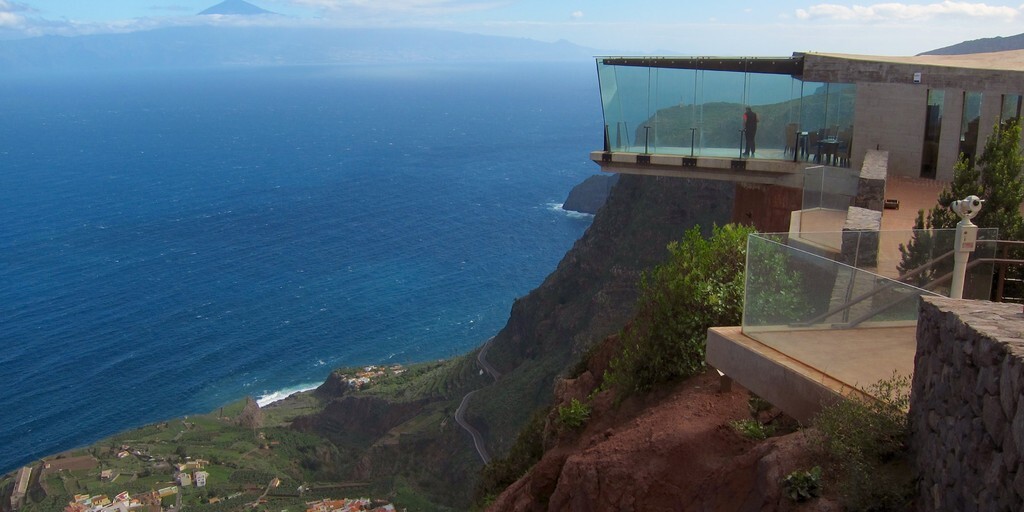
Mirador de Abrante. At first glance, Abrante seems like a typical viewpoint. However, atop the cliff in the north of La Gomera, where the viewpoint is located, visitors not only have a view of the steep rock, but also "float" above it. At the end of the viewpoint is a seven-meter-high overhang with a glass floor. Those who dare to walk on it are practically suspended in the air, taking in the rural landscape typical of the Canary Islands. There's also a restaurant here where you can enjoy a drink.
We then drive to the small town of Valle Gran Rey. It's a bit busier here than the rest of the island, but it's cozy, relaxed, and friendly, making it a good place to take a break and stretch your legs or have a drink or a bite to eat in one of the many restaurants or bars.
We return a short distance along the same road, then turn right into Garajonay National Park. There's an Information Center about the park and a small restaurant-bar, Laguna Grande, where you can get information and enjoy a bite to eat and a drink. Those who enjoy it can take a short walk through the beautiful natural surroundings.
We continue the journey back to the port to make the crossing to Tenerife.
 Links
Links  Usage
Usage Want to download this route?
You can download the route for free without MyRoute-app account. To do so, open the route and click 'save as'. Want to edit this route?
No problem, start by opening the route. Follow the tutorial and create your personal MyRoute-app account. After registration, your trial starts automatically.  Disclaimer
Use of this GPS route is at your own expense and risk. The route has been carefully composed and checked by a MyRoute-app accredited RouteXpert for use on TomTom, Garmin and MyRoute-app Navigation.
Changes may nevertheless have occurred due to changed circumstances, road diversions or seasonal closures. We therefore recommend checking each route before use.
Preferably use the route track in your navigation system. More information about the use of MyRoute-app can be found on the website under 'Community' or 'Academy'.