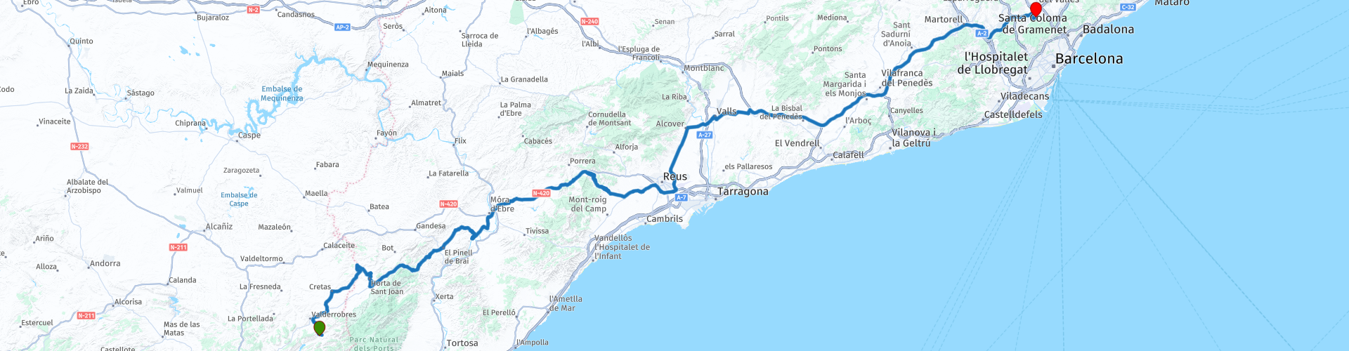
From Beceite to Cerdanyola visiting Horta de Sant Joan and Miravet

This route was brought to you by:
RouteXpert b0hd1
Last edit: 14-01-2022
 Route Summary
 Later a visit will be made to Miravet. This pretty town is located on a bend in the river dominated by a Templar castle of Islamic origin. Miravet is undoubtedly an essential visit on any route through Tarragona.
4 stars since although the landscape and the roads are not the best, the scheduled visits are excellent !!
Suitable for any type of biker, alone or accompanied.
 Share this route


Animation

Verdict


Duration
8h 22m

Mode of travel
Car or motorcycle

Distance
252.74 km

Countries

 RouteXpert Review
 Horta de Sant Joan is a medieval town in Terra Alta located in the province of Tarragona, within the Els Ports Natural Park.
The town was declared a Cultural Asset of National Interest for its Historic-Artistic Complex. The Romanesque-Gothic church (12th century), its narrow and steep streets, the Picasso museum, the Ecomuseum of the Ports, the old Horta prison, and Lo Parot, an olive tree declared a monumental tree due to its two thousand-year antiquity, stand out.
Near Horta de Sant Joan passes the Terra Alta Greenway, formed by the old Val de Zafán railway line. Within the park is the Caça dels Ports National Reserve.
MIRAVET:
Miravet Castle
It is the most spectacular place in this medieval town, its castle. You can get there by motorcycle or walking. The walk lasts fifteen or twenty minutes and is very well signposted. It is all climb, but it is not very steep so it goes up without complication.
The price is € 5, although for students, youth card or retirees, among others, they have a € 2 discount on the price. Summer opening hours are from 10:00 a.m. to 8:00 p.m. while in winter they close at 5:30 p.m., except for January and February, which close at 4:00 p.m.
Inside the castle of Miravet is a marvel and although it was partially destroyed during the Battle of the Ebro it is still well preserved. You come to a patio where you could see the whole town and the Ebro river, beautiful views
The next stop was the old church, another of the essential sites if you visit Miravet and which is also located in the heart of the old town.
This church was built in the Renaissance period between the 16th and 17th centuries and remained abandoned for a long time until it was restored. Now it has become a cultural and historical monument of Miravet and quite an interesting visit. It is said to have been built where the old mosque from the Muslim era might previously have been located.
Paso de la Barca
It is one of the best known and most surprising activities that can be done in Miravet. Actually, it is nothing more than reaching the river and getting on the motorcycle in a boat to cross it, in this way you get to the opposite side. But it is very surprising and people do it because it is the last boat crossing in the entire Ebro that works without a motor. An experience that does not leave you indifferent!
The price to cross to the other side of the river is € 3 per vehicle, you can also cross without a vehicle for € 1 per person. Although crossing without a vehicle does not make much sense, since on the other side of the river there is nothing until a few kilometers later. You can walk a bit along the path that passes next to the Ebro. The hours are from 09:00 to 19:00, although in winter they close an hour earlier.
The jetty
If you have seen any photos of Miravet, it is probably from this point. It is the best place to see the panoramic view of the town and from where you will also have the best views of the castle. If you go at sunset you will have a beautiful sunset and the reflection of the views in the water, a perfect plan!
RIUDECANYES SWAMP
In a relaxed setting, about fifteen kilometers from Cambrils and a short distance from the busy beaches and towns of the Costa Daurada, is the Riudecanyes reservoir, in the Baix Camp region. This reservoir was built at the beginning of the 20th century to supply the city of Reus with drinking water and which today is also used to irrigate other towns in this Tarragona region.
The reservoir was put into operation in 1918, promoted by the Riudecanyes Irrigation Community, an entity made up of the Reus City Council and various individuals, and which is still the owner today. Years later, the reservoir underwent works to double its capacity, which is currently 5.3 cubic hectometres, and which allows it to store water from the Riudecanyes stream and the Siurana hydrographic system.
Access to the reservoir is easy and there is a parking area, from there in about ten minutes you can reach the picnic area. You can admire its landscape of white pine and go on excursions to the mountains of the Sierra de l'Argentera. One recommendation: stop on the Duesaigües road, in the direction of the town of Riudecanyes, to see how the water of the reservoir, the sea in the distance and the sky converge. A postcard of very beautiful blues.
For a few years, in addition, swimming has been allowed in the reservoir and you can practice small-scale nautical activities such as paddle surfing, pedal boats and kayaking. There, the non-profit association, Riudecanyes Aventura, made up of the municipalities of Riudecanyes, Duesaigües and L'Argentera, allows you to rent equipment and organize classes in these sports. Other companies in the area also offer these services and propose guided routes and excursions on horseback that connect the reservoir with the town of Riudecanyes.
Once in the town, you can visit its old town and you can see a nice peculiarity: the names of the streets correspond to the names of the days of the week. In the carrer del Dimecres (Wednesday) we will find the Renaissance church of Sant Mateu, with its peculiar columns of crushed stone, and you can climb its bell tower, which is 25 meters high, and from which you can see the framework of this Municipality.
Likewise, from the urban center of Riudecanyes, a road leads directly to the Monastery Castle of Sant Miquel d'Escornalbou, from the end of the 12th century. It can also be accessed by local roads, from L'Argentera and Vilanova d'Escornalbou. Of all the architectural complex, it is convenient to look at the Romanesque church, the chapter house, the cloister and the manor house from the early 20th century. At the top, 649 meters high, the hermitage of Santa Bárbara offers unbeatable views of the province.
Oil and the modernist legacy:
It is a good activity to do as a family, as is visiting the Landscape Fruit Interpretation Center, located in the old building and mill of the Agricultural Cooperative of Riudecanyes. This space is designed to didactically discover the landscapes, the orchard and some of the products that are born in the Baix Camp mountains, such as hazelnuts, Prades potatoes and extra virgin olive oil from Arbequina, among others.
The area, land of centuries-old olive trees, invites you to practice oleotourism and taste the extra virgin olive oil, a great jewel of Mediterranean gastronomy
And it is that the area, land of centuries-old olive trees, invites you to practice oleotourism and discover this great jewel of Mediterranean gastronomy. In the same Cooperativa de Riudecanyes, guided tours are organized for families and used groups to learn about the artisan work of the olive harvest and the production of extra virgin olive oil, as well as oil tastings and tastings, cooking classes and we even offer the possibility of having breakfast or eating among olive trees.


 Links
Links  Usage
Usage Want to download this route?
You can download the route for free without MyRoute-app account. To do so, open the route and click 'save as'. Want to edit this route?
No problem, start by opening the route. Follow the tutorial and create your personal MyRoute-app account. After registration, your trial starts automatically.  Disclaimer
Use of this GPS route is at your own expense and risk. The route has been carefully composed and checked by a MyRoute-app accredited RouteXpert for use on TomTom, Garmin and MyRoute-app Navigation.
Changes may nevertheless have occurred due to changed circumstances, road diversions or seasonal closures. We therefore recommend checking each route before use.
Preferably use the route track in your navigation system. More information about the use of MyRoute-app can be found on the website under 'Community' or 'Academy'.

Aragon
About this region
Aragon ( or , Spanish and Aragonese: Aragón [aɾaˈɣon], Catalan: Aragó [əɾəˈɣo]) is an autonomous community in Spain, coextensive with the medieval Kingdom of Aragon. In northeastern Spain, the Aragonese autonomous community comprises three provinces (from north to south): Huesca, Zaragoza, and Teruel. Its capital is Zaragoza. The current Statute of Autonomy declares Aragon a historic nationality of Spain.
Covering an area of 47720 km2 (18420 sq mi), the region's terrain ranges diversely from permanent glaciers to verdant valleys, rich pasture lands and orchards, through to the arid steppe plains of the central lowlands. Aragon is home to many rivers—most notably, the river Ebro, Spain's largest river in volume, which runs west–east across the entire region through the province of Zaragoza. It is also home to the highest mountains of the Pyrenees.
As of January 2020, the population of Aragon was 1329391, with over half of it living in its capital city, Zaragoza. During the same year, the economy of Aragon generated a GDP of €34687 million, which represents 3.1% of Spain's national GDP, and is currently 6th in per capita production behind Madrid, Basque Country, Navarre, Catalonia and La Rioja.In addition to its three provinces, Aragon is subdivided into 33 comarcas or counties. All comarcas of Aragon have a rich geopolitical and cultural history from its pre-Roman, Celtic and Roman days, four centuries of Islamic rule as Marca Superior of Al-Andalus or kingdom (or taifa) of Saraqusta, as lands that once belonged to the Frankish Marca Hispanica, counties that later formed the Kingdom of Aragon, and eventually the Crown of Aragon.
Read more on Wikipedia
Covering an area of 47720 km2 (18420 sq mi), the region's terrain ranges diversely from permanent glaciers to verdant valleys, rich pasture lands and orchards, through to the arid steppe plains of the central lowlands. Aragon is home to many rivers—most notably, the river Ebro, Spain's largest river in volume, which runs west–east across the entire region through the province of Zaragoza. It is also home to the highest mountains of the Pyrenees.
As of January 2020, the population of Aragon was 1329391, with over half of it living in its capital city, Zaragoza. During the same year, the economy of Aragon generated a GDP of €34687 million, which represents 3.1% of Spain's national GDP, and is currently 6th in per capita production behind Madrid, Basque Country, Navarre, Catalonia and La Rioja.In addition to its three provinces, Aragon is subdivided into 33 comarcas or counties. All comarcas of Aragon have a rich geopolitical and cultural history from its pre-Roman, Celtic and Roman days, four centuries of Islamic rule as Marca Superior of Al-Andalus or kingdom (or taifa) of Saraqusta, as lands that once belonged to the Frankish Marca Hispanica, counties that later formed the Kingdom of Aragon, and eventually the Crown of Aragon.
View region
 Statistics
  34
34Amount of RX reviews (Aragon)
 12011
12011Amount of visitors (Aragon)
 2504
2504Amount of downloads (Aragon)
 Route Collections in this region
 7 day roundtrip from Girona to Catalonia Andorra and the Pyrenees
The Pyrenees stretch for more than 450 kilometers from the Bay of Biscay in the west to the Cap de Creus on the Mediterranean. The mountain range, with peaks of more than 3000 meters, forms a natural barrier that cuts off the Iberian Peninsula from the rest of Europe. The main ridge of the mountain range also largely forms the state border between France and Spain, while the microstate Andorra lies between these two countries.
Bordering the Pyrenees is Catalonia, the hinterland of Barcelona. No wonder many new models of motorcycles are introduced to the press in Catalonia. There are many great ways to test the new models there. An additional advantage is that it is very quiet! You would almost say 'too quiet' because there is a danger that at some point you will use the entire width of the road, under the guise of 'you won't see oncoming traffic here'.... But let's keep it safe and stay on the right side of the center line.
These seven routes of this collection pass through these beautiful areas. Each and every one of these routes where especially the sides of the tires have a hard time. Whether on the gentle slopes in Catalonia or on the balcony roads in the Gorges in the French Pyrenees, make sure they're excited, because you can bet it's going to be exciting!
A few sights are discussed in the review for each route. These often tell something about the history of the area in which you drive. Fun facts, quite educational. There are also places where you can refuel and where you can drink coffee and/or have lunch. You are completely free to visit these places, you can of course also determine your own points of interest.
But the main thing you probably traveled to this area for is simply driving. And as mentioned above, you are in a true motorcycle paradise where the steering is fantastic!
Each route ends at a hotel. It is of course not an obligation to use these hotels, you can always find another place to stay in the area, that decision is up to you. My experience, however, is that they are all simple but good hotels for a very reasonable price. They are known and can be booked at booking.com.
The routes of these collections:
R01 - Girona to Sant Julia de Loria, 269km
R02 - Sant Julia de Loria to Pierrefitte Nestalas, 290km
R03 - Pierrefitte Nestalas to Barbastro, 291km
R04 - Barbastro to Puig Reig, 266km
R05 - Puig Reig to Figueres, 268km
R06 - Figueres to Quillan, 243km
R07 - Quillan to Gironam, 286km
Have fun driving these routes!
View Route Collection
Ten Day Roadtrip from Spain to Portugal
This route collection describes a 10-day Road trip in the north of Spain and Portugal, a true paradise for motorcycling.
You drive over beautiful mountain ridges and through beautiful valleys. Along the way you drive through beautiful villages and countless nature reserves, great passes with countless curves, tunnels cut out of the mountains and azure blue reservoirs. The roads are fair to good, sometimes unpaved.
What you get to see along the way;
Spanish Pyrenees
Parc Naturel del Cadi-Moixero
Serra del Cadí
Serra de Moixeró
Pedraforca
Serra del Monsec
Collada de Clarà
Parque Nacional de Ordesa y Monte Perdido
Collados del Asón Natural Park.
Parque natural Saja-Besaya
Parque natural de Fuentes Carrionas y Fuente Cobre
Parque natural de la Montana de Riano y Mampodre
Picos de Europa
El Parque regional Montaña de Riaño y Mampodre
El Parque natural de Redes
The Sierra de la Culebra
Parque natural Montesinho
Along the routes there are more than enough nice places to stop for a short or longer period, these are described in the review and with a waypoint and POI included in the routes.
Have fun reading and planning your next motorcycle vacation.
If you have ridden these routes I would like to hear your feedback.
View Route Collection