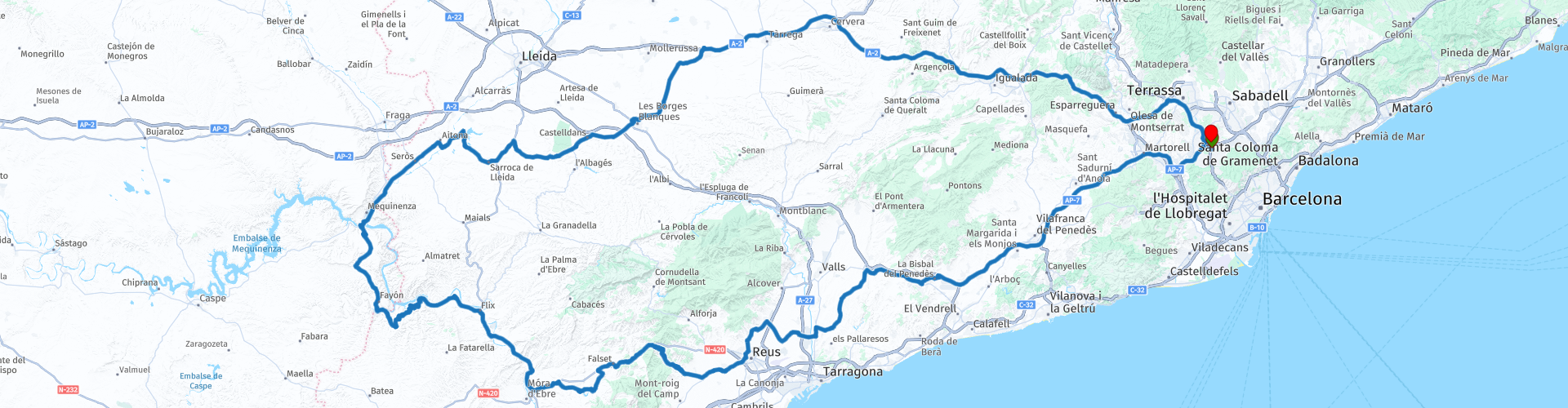
Round trip Sant Cugat through Mequinenza and visiting the reservoirs of southern Catalonia

This route was brought to you by:
RouteXpert b0hd1
Last edit: 31-10-2022
 Route Summary
 Route indicated for experienced bikers due to its secondary roads and duration of it.
Between route points 9 and 12, the route runs for more than 3 kilometers on gravel.
4 stars for the fantastic roads and the beautiful views of the reservoirs.
 Share this route


Animation

Verdict


Duration
9h 13m

Mode of travel
Car or motorcycle

Distance
449.42 km

Countries

 RouteXpert Review
 MEQUINENZA:
A town on the banks of three rivers that form one of the largest river confluences in Europe. Its old quarter was flooded to build the huge reservoir that bears its name, popularly known as Mar de Aragón.
The imposing castle of Mequinenza watches over the new town center of the town, built in the sixties. In addition to a pleasant walk, Mequinenza offers you three museum spaces of great interest: the Mining, History and Prehistory museums.
Being located between two large bodies of water, the Mequinenza reservoir (known as the Mar de Aragón) and the Ribarroja reservoir, Mequinenza becomes a difficult destination to refuse for lovers of fishing (carp, black-bass, pike -perch, catfish…) and water sports.
Likewise, the town offers one of the best Olympic fields in the country for holding regattas (rowing and canoeing).
The passage through the various reservoirs is interesting:
UTXEA RESERVOIR:
The Protected Natural Area of Utxesa is one of the enclaves of inland Catalonia which, thanks to its reservoir, is of greater ornithological interest, both for the diversity of migratory and sedentary waterfowl that are found there as well as for the wet riverside vegetation, the which is of incomparable characteristics in a territory of pseudo-steppe character.
On the one hand, the surroundings of the Utxesa reservoir, used as a hydroelectric exploitation and which provides water to several urbanizations, constitutes a very important example of the tabular relief typical of the western lands. On the other hand, the aquatic mass of the reservoir and its surroundings constitute an important landscape milestone in this entire sector.
There are paths for hiking and mountain biking, bird watching areas and different witnesses of important historical and cultural value have survived, such as the hermitage of Carrassumada, the castle of Sarroca in Lleida or the Creu de Terme.
MEQUINENZA RESERVOIR:
The immensity of the reservoir is home to hundreds of coves, aquatic species, trails and some surprises, such as the remains of the hermitage and the convent of La Magdalena on the island of the same name; a place with magic and a halo of mystery. Not in vain exorcisms were performed in the place, one of the most photographed in the area.
RIBARROJA RESERVOIR:
At the confluence of the Ebro and Matarraña rivers, the lowest point in Aragon is located, the Ribarroja reservoir, at about 70 meters above sea level. From the hermitage of Pilar, the reservoir and its conditions can be appreciated in all its magnitude. Nearby there are also places of interest such as the Fabara mausoleum, the best preserved in Spain.
GUIAMETS RESERVOIR
The Embalse dels Guiamets, which is located in the southern part of the Priorat region, receives the waters of the Capçanes torrent. It is an ideal place to enjoy nature where you can see a wide variety of birds such as the gray heron, the egret, the sea crow or the green-necked duck.
You can also practice canoeing. The Servikayak company is dedicated to renting kayaks to enjoy this magnificent environment. It also has an area with hammocks and a mini-pool for the little ones.
To get there you have to take the first cemented path that goes to the right from the road that goes from Guiamets to Capçanes.
RIUDECANYES RESERVOIR:
Riudecanyes is a small municipality located inland from the coast of Tarragona, right in the Baix Camp region. It is located in an ideal place, straddling the mountains and the sea, which is only 10 kilometers away.
Riudecanyes is characterized by three essential elements that make it an original town. In the first place, the streets, all of them had the names of the days of the week, but for some time now the nomenclature of the streets has had to be expanded as they have increased in number. Secondly, the Riudecanyes reservoir stands out, which is located between the town and the mountains and turns the environment into a pleasant space with a unique landscape where you can walk or enjoy the surrounding pine forests or even fish. And, thirdly, in Riudecanyes we find, on the highest peak of the town, the most spectacular building in the entire nucleus: the castle-monastery of Sant Miquel d'Escornalbou. In fact, we cannot leave Riudecanyes without visiting the castle. This one dates from the 12th century and was promoted by King Alfonso I. After passing through several hands, the current owner has begun the restoration trying to maintain the original appearance, from which we can still clearly see the presence of the Romanesque style.
Despite these three basic elements of Riudecanyes, the town offers other elements that deserve special attention, such as the Renaissance church of Sant Mateu built in 1582. Mortar and stone were used throughout the construction. , in addition to making the columns of crushed stone and the laps of brick and chalk. It has an altar 25 meters high and originally had a main altar that had eight chapels and fourteen altars.
As far as the environment is concerned, Riudecanyes has an appreciable natural area through which you can walk and make routes. In this area we can highlight the Pineda and the Sureda d'Escornalbou and the Glaneres Park.


 Links
Links  Usage
Usage Want to download this route?
You can download the route for free without MyRoute-app account. To do so, open the route and click 'save as'. Want to edit this route?
No problem, start by opening the route. Follow the tutorial and create your personal MyRoute-app account. After registration, your trial starts automatically.  Disclaimer
Use of this GPS route is at your own expense and risk. The route has been carefully composed and checked by a MyRoute-app accredited RouteXpert for use on TomTom, Garmin and MyRoute-app Navigation.
Changes may nevertheless have occurred due to changed circumstances, road diversions or seasonal closures. We therefore recommend checking each route before use.
Preferably use the route track in your navigation system. More information about the use of MyRoute-app can be found on the website under 'Community' or 'Academy'.

Catalonia
About this region
Catalonia (; Catalan: Catalunya [kətəˈluɲə, kataˈluɲa]; Aranese Occitan: Catalonha [kataˈluɲa]; Spanish: Cataluña [kataˈluɲa]) is an autonomous community in the northeastern corner of Spain, designated as a nationality by its Statute of Autonomy.Catalonia consists of four provinces: Barcelona, Girona, Lleida, and Tarragona. The capital and largest city, Barcelona is the second-most populated municipality in Spain and the fifth-most populous urban area in the European Union. It comprises most of the former Principality of Catalonia (with the remainder Roussillon now part of France's Pyrénées-Orientales). It is bordered by France (Occitanie) and Andorra to the north, the Mediterranean Sea to the east, and the Spanish autonomous communities of Aragon to the west and Valencia to the south. The official languages are Catalan, Spanish, and the Aranese dialect of Occitan.In the late 8th century, various counties across the eastern Pyrenees were established by the Frankish kingdom as a defensive barrier against Muslim invasions. In the 10th century the County of Barcelona became progressively independent. In 1137, Barcelona and the Kingdom of Aragon were united by marriage under the Crown of Aragon. Within the Crown, the Catalan counties adopted a common polity, the Principality of Catalonia, developing its own institutional system, such as Courts, Generalitat and constitutions, becoming the base for the Crown's Mediterranean trade and expansionism. In the later Middle Ages, Catalan literature flourished. In 1469, the king of Aragon and the queen of Castile were married and ruled their realms together, retaining all of their distinct institutions and legislation.
During the Franco-Spanish War (1635–1659), Catalonia revolted (1640–1652) against a large and burdensome presence of the royal army, being briefly proclaimed a republic under French protection, until it was largely reconquered by the Spanish army. By the Treaty of the Pyrenees (1659), the northern parts of Catalonia, mostly the Roussillon, were ceded to France. During the War of the Spanish Succession (1701–1714), the Crown of Aragon sided against the Bourbon Philip V of Spain; following Catalan defeat on 11 September 1714, Philip V imposed a unifying administration across Spain, enacting the Nueva Planta decrees which, like in the other realms of the Crown of Aragon, suppressed the Catalan institutions and rights. This led to the eclipse of Catalan as a language of government and literature, replaced by Spanish. Throughout the 18th century, Catalonia experienced economic growth.
In the 19th century, Catalonia was severely affected by the Napoleonic and Carlist Wars. In the second third of the century, it experienced industrialisation. As wealth from the industrial expansion grew, it saw a cultural renaissance coupled with incipient nationalism while several workers movements appeared. With the establishment of the Second Spanish Republic (1931–1939), the Generalitat was restored as a Catalan autonomous government. After the Spanish Civil War, the Francoist dictatorship enacted repressive measures, abolishing Catalan self-government and banning the official use of the Catalan language. After a period of autarky, from the late 1950s through to the 1970s Catalonia saw rapid economic growth, drawing many workers from across Spain, making Barcelona one of Europe's largest industrial metropolitan areas and turning Catalonia into a major tourist destination. During the Spanish transition to democracy (1975–1982), Catalonia regained self-government and is now one of the most economically dynamic communities of Spain.
Since the 2010s there has been growing support for Catalan independence. On 27 October 2017, the Catalan Parliament unilaterally declared independence following a disputed referendum. The Spanish Senate voted in favour of enforcing direct rule by removing the Catalan government and calling a snap regional election. The Spanish Supreme Court imprisoned seven former ministers of the Catalan government on charges of rebellion and misuse of public funds, while several others—including then-President Carles Puigdemont—fled to other European countries.
Read more on Wikipedia
During the Franco-Spanish War (1635–1659), Catalonia revolted (1640–1652) against a large and burdensome presence of the royal army, being briefly proclaimed a republic under French protection, until it was largely reconquered by the Spanish army. By the Treaty of the Pyrenees (1659), the northern parts of Catalonia, mostly the Roussillon, were ceded to France. During the War of the Spanish Succession (1701–1714), the Crown of Aragon sided against the Bourbon Philip V of Spain; following Catalan defeat on 11 September 1714, Philip V imposed a unifying administration across Spain, enacting the Nueva Planta decrees which, like in the other realms of the Crown of Aragon, suppressed the Catalan institutions and rights. This led to the eclipse of Catalan as a language of government and literature, replaced by Spanish. Throughout the 18th century, Catalonia experienced economic growth.
In the 19th century, Catalonia was severely affected by the Napoleonic and Carlist Wars. In the second third of the century, it experienced industrialisation. As wealth from the industrial expansion grew, it saw a cultural renaissance coupled with incipient nationalism while several workers movements appeared. With the establishment of the Second Spanish Republic (1931–1939), the Generalitat was restored as a Catalan autonomous government. After the Spanish Civil War, the Francoist dictatorship enacted repressive measures, abolishing Catalan self-government and banning the official use of the Catalan language. After a period of autarky, from the late 1950s through to the 1970s Catalonia saw rapid economic growth, drawing many workers from across Spain, making Barcelona one of Europe's largest industrial metropolitan areas and turning Catalonia into a major tourist destination. During the Spanish transition to democracy (1975–1982), Catalonia regained self-government and is now one of the most economically dynamic communities of Spain.
Since the 2010s there has been growing support for Catalan independence. On 27 October 2017, the Catalan Parliament unilaterally declared independence following a disputed referendum. The Spanish Senate voted in favour of enforcing direct rule by removing the Catalan government and calling a snap regional election. The Spanish Supreme Court imprisoned seven former ministers of the Catalan government on charges of rebellion and misuse of public funds, while several others—including then-President Carles Puigdemont—fled to other European countries.
View region
 Statistics
  50
50Amount of RX reviews (Catalonia)
 23067
23067Amount of visitors (Catalonia)
 3037
3037Amount of downloads (Catalonia)
 Route Collections in this region
 7 day roundtrip from Girona to Catalonia Andorra and the Pyrenees
The Pyrenees stretch for more than 450 kilometers from the Bay of Biscay in the west to the Cap de Creus on the Mediterranean. The mountain range, with peaks of more than 3000 meters, forms a natural barrier that cuts off the Iberian Peninsula from the rest of Europe. The main ridge of the mountain range also largely forms the state border between France and Spain, while the microstate Andorra lies between these two countries.
Bordering the Pyrenees is Catalonia, the hinterland of Barcelona. No wonder many new models of motorcycles are introduced to the press in Catalonia. There are many great ways to test the new models there. An additional advantage is that it is very quiet! You would almost say 'too quiet' because there is a danger that at some point you will use the entire width of the road, under the guise of 'you won't see oncoming traffic here'.... But let's keep it safe and stay on the right side of the center line.
These seven routes of this collection pass through these beautiful areas. Each and every one of these routes where especially the sides of the tires have a hard time. Whether on the gentle slopes in Catalonia or on the balcony roads in the Gorges in the French Pyrenees, make sure they're excited, because you can bet it's going to be exciting!
A few sights are discussed in the review for each route. These often tell something about the history of the area in which you drive. Fun facts, quite educational. There are also places where you can refuel and where you can drink coffee and/or have lunch. You are completely free to visit these places, you can of course also determine your own points of interest.
But the main thing you probably traveled to this area for is simply driving. And as mentioned above, you are in a true motorcycle paradise where the steering is fantastic!
Each route ends at a hotel. It is of course not an obligation to use these hotels, you can always find another place to stay in the area, that decision is up to you. My experience, however, is that they are all simple but good hotels for a very reasonable price. They are known and can be booked at booking.com.
The routes of these collections:
R01 - Girona to Sant Julia de Loria, 269km
R02 - Sant Julia de Loria to Pierrefitte Nestalas, 290km
R03 - Pierrefitte Nestalas to Barbastro, 291km
R04 - Barbastro to Puig Reig, 266km
R05 - Puig Reig to Figueres, 268km
R06 - Figueres to Quillan, 243km
R07 - Quillan to Gironam, 286km
Have fun driving these routes!
View Route Collection
Ten Day Roadtrip from Spain to Portugal
This route collection describes a 10-day Road trip in the north of Spain and Portugal, a true paradise for motorcycling.
You drive over beautiful mountain ridges and through beautiful valleys. Along the way you drive through beautiful villages and countless nature reserves, great passes with countless curves, tunnels cut out of the mountains and azure blue reservoirs. The roads are fair to good, sometimes unpaved.
What you get to see along the way;
Spanish Pyrenees
Parc Naturel del Cadi-Moixero
Serra del Cadí
Serra de Moixeró
Pedraforca
Serra del Monsec
Collada de Clarà
Parque Nacional de Ordesa y Monte Perdido
Collados del Asón Natural Park.
Parque natural Saja-Besaya
Parque natural de Fuentes Carrionas y Fuente Cobre
Parque natural de la Montana de Riano y Mampodre
Picos de Europa
El Parque regional Montaña de Riaño y Mampodre
El Parque natural de Redes
The Sierra de la Culebra
Parque natural Montesinho
Along the routes there are more than enough nice places to stop for a short or longer period, these are described in the review and with a waypoint and POI included in the routes.
Have fun reading and planning your next motorcycle vacation.
If you have ridden these routes I would like to hear your feedback.
View Route Collection