Provence Bergen en Meren

This route was brought to you by:
RouteXpert Hans van de Ven (Mr.MRA)
Last edit: 18-04-2021
 Route Summary
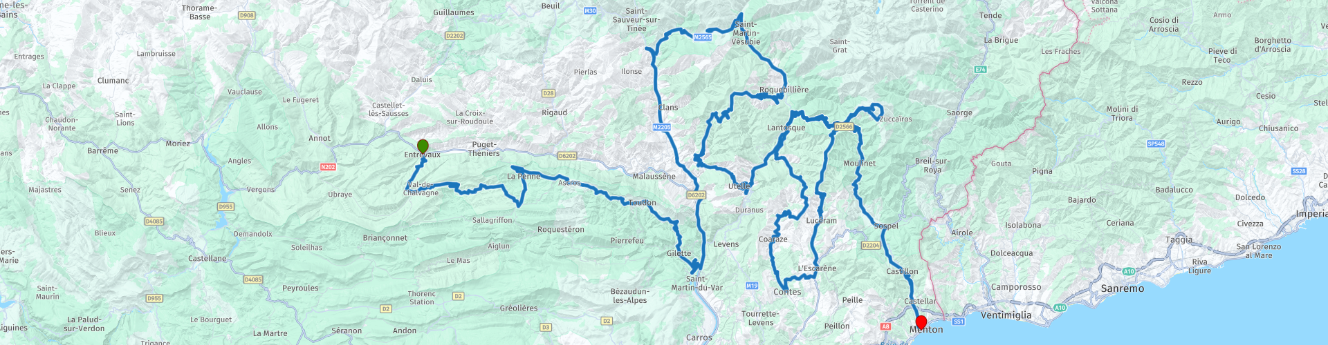
 Start: Entrevaux
Finish: Menton
The route made the same for TomTom, Garmin and MyRoute-app Navigation users.
If you want to ride this TT, keep the info below in mind:
- Average mountain experience
- TT from A to B
- Accommodation necessary
Source: Promoter 07, September / October 2018.
 Share this route


Animation

Verdict


Duration
12h 45m

Mode of travel
Car or motorcycle

Distance
374.35 km

Countries

 RouteXpert Review
 Passes and mountain roads: Col des Félines (930 m), Col du Trébuchet (1143 m), Col de St. Raphaël (876 m), mountain road to Mont Vial (1549 m), Col des Sauses (629 m), Col St Martin (1500 m), Col d´Andrion (1681 m), Col de Turini (1607 m), Col de Braus (1002 m), Col de Castillon (628 m)
Specifics route:
- Winter closure: no official winter closure, depending on the weather
- Alternative routes: Uphill (unpaved) to the 1549 m high Mont Vial; D17 over Roquesteron to Gilette (over the Route Canyon Clue du Riolan); from Roquebillière over the Col d´Andrion (partly unpaved) to Tour and from there on to Utelle, from Utelle the alternative to the church of Madone d´Utelle (1174 m); ring road (D 68) to Fort Mille Fourches, after the Col de Turini
- Ideal months: early spring to early summer. Then again the autumn period.
- Roads: In the summer split is spread, for example on the Col de Turini. The alternative routes sometimes have unpaved sections.
- Driving pleasure: Everywhere! Very special: D911 / D10 between Entrevaux and la Rochette; the D27 ridge road between Ascros and the D17 near Gilette; Col de Turini, Col de Braus
- Landscape: Entrevaux (medieval town view); Col du Trébuchet with the Montagne de Gourdan; Canyon Clue du Riolan; cam road D27 Ascros and Gilette; Mont Vial; Utelle and the church Madone d´Utelle; Gorges de la Vésubie
This 5 star route is one of the 24 most beautiful Alpine routes in recent years!


 Links
Links  Usage
Usage Want to download this route?
You can download the route for free without MyRoute-app account. To do so, open the route and click 'save as'. Want to edit this route?
No problem, start by opening the route. Follow the tutorial and create your personal MyRoute-app account. After registration, your trial starts automatically.  Disclaimer
Use of this GPS route is at your own expense and risk. The route has been carefully composed and checked by a MyRoute-app accredited RouteXpert for use on TomTom, Garmin and MyRoute-app Navigation.
Changes may nevertheless have occurred due to changed circumstances, road diversions or seasonal closures. We therefore recommend checking each route before use.
Preferably use the route track in your navigation system. More information about the use of MyRoute-app can be found on the website under 'Community' or 'Academy'.