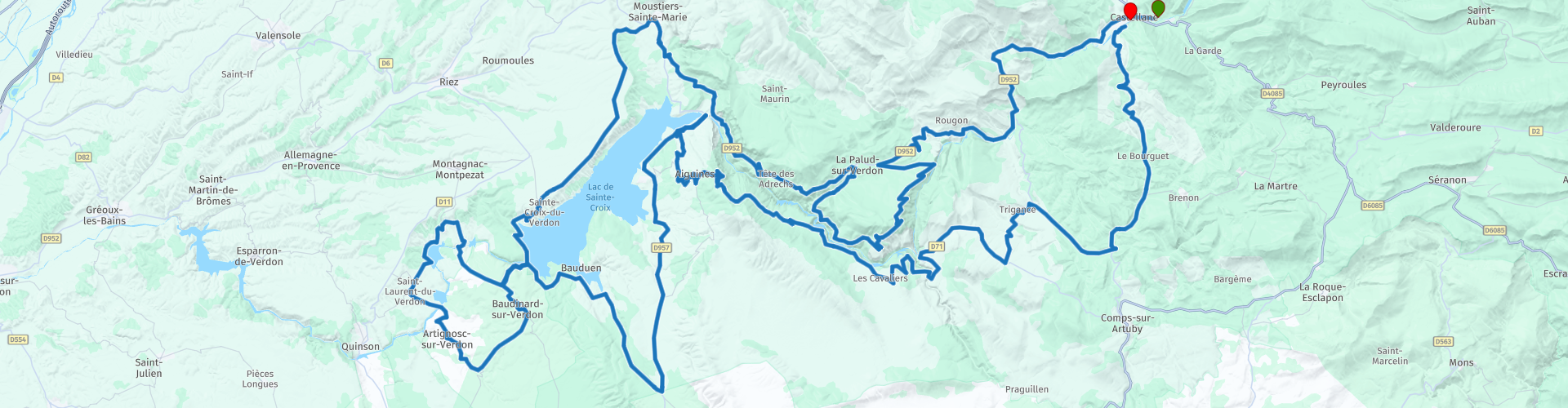
Rondrit Gorges du Verdon vanuit Castellane

This route was brought to you by:
RouteXpert Marcel Scherpenkate
Last edit: 28-03-2021
 Route Summary
  Share this route


Animation

Verdict


Duration
4h 32m

Mode of travel
Car or motorcycle

Distance
210.22 km

Countries

 RouteXpert Review
 The route goes via the north side of the gorge via La Route des Crêtes, a breathtakingly beautiful piece of nature, to the Lac de Sainte Croix. At route point 12 in Aiguines at restaurant Altitude 823 we had lunch and from there you have a beautiful view over the reservoir. Via the south side it meanders along the canyon with enough possibilities to stop for a moment to take a picture. but especially to enjoy the beautiful winding roads.
Below some more information about the area:
The Gorges du Verdon or the Grand Canyon du Verdon is a gorge on the border between the departments of Var and Alpes-de-Haute-Provence in the south of France. It is located between Castellane and Moustiers-Sainte-Marie, known for its faience, a type of earthenware characterized by its glaze decoration. It is the largest gorge in Europe after the Tarakloof in Montenegro, worn by the Verdon River over a length of 25 km.
The gorge is located in the Verdon Regional Natural Park, 180,000 hectares.
The gorge ends in the reservoir of Sainte-Croix-du-Verdon, the Lac de Sainte-Croix. With the construction of this lake was started in 1973, in 1975 it was filled. The lake is 14 km long and 2 km wide. The village of Salles-sur-Verdon disappeared due to the construction of this lake and was rebuilt on the east bank. The Sainte-Croix lake is the gateway to the Gorges du Verdon, the second largest canyon in Europe and is a major tourist attraction.
The rock walls of the Gorges du Verdon are up to 700 m high and attract many tourists.
Motorways with viewpoints over the gorge run on both sides. To the north of the Verdon river, this is the Route des Crêtes, south of the Verdon de Corniche Sublime.
It is a popular area for mountaineers and nature lovers. There are more than 100 kilometers of hiking trails, including the famous Martel Trail. This fifteen kilometer long path from the chalet de la Maline to the Samson Passage is named after the French speleologist Édouard-Alfred Martel. In 1905 he made the first trip across the bottom of the gorge. The Gorge owes its nickname the Grand Canyon du Verdon. For he is quoted as saying: "The gorge of the Verdon is the most American of all French ravines, which I keep after seeing the Grand Canyon."


 Links
Links  Usage
Usage Want to download this route?
You can download the route for free without MyRoute-app account. To do so, open the route and click 'save as'. Want to edit this route?
No problem, start by opening the route. Follow the tutorial and create your personal MyRoute-app account. After registration, your trial starts automatically.  Disclaimer
Use of this GPS route is at your own expense and risk. The route has been carefully composed and checked by a MyRoute-app accredited RouteXpert for use on TomTom, Garmin and MyRoute-app Navigation.
Changes may nevertheless have occurred due to changed circumstances, road diversions or seasonal closures. We therefore recommend checking each route before use.
Preferably use the route track in your navigation system. More information about the use of MyRoute-app can be found on the website under 'Community' or 'Academy'.