MTG2 14 French Alpes Annecy Thones Flumet Bourg St Maurice

This route was brought to you by:
RouteXpert René Plücken (MRA Master)
Last edit: 12-02-2021
 Route Summary
 climate. It is not for nothing that you see so many motorcyclists there. My previous series of routes in France were based on the route descriptions from the Motortourgids France part 1 made by Bert Loorbach.
This route comes from Motortourgids France part 2 and the original name is "The Alps Directions 3: from Annecy to Bourg St Maurice".
In Motorbike guide France part 2 a difference has been made between approach routes and trips in a certain area. The approach routes can also be used in combination with the routes from Motortourgids France part 1
The routes are sometimes slightly adjusted based on the tips that Bert Loorbach gives in his description, or because of a different place to spend the night, or to achieve the minimum length of 2 hours for the MRA Library. For each route there is a more detailed description in the review, including options to stay overnight or places of interest en route, which are also indicated with a POI and if possible with a short description
The route is made suitable for Garmin, TomTom, Harley-Davidson BoomBox 2019 and Navigation App, can be downloaded for free and without My-Route-app registration. To do this, first click on the 'Use route' button and then on 'Save as'.
 Share this route


Animation

Verdict


Duration
3h 3m

Mode of travel
Car or motorcycle

Distance
132.92 km

Countries

 RouteXpert Review
 The Alps have to appeal to almost every motorcyclist. High passes, deep valleys, mountain lakes, glaciers and rugged peaks. Among these peaks is the highest in Europe: the Mont Blanc. All this beauty is connected to mountain roads of usually very good quality and must therefore yield a motorcycle cocktail to write home about. So with this the third route of a series of five from the Motorbike Guide part 2.
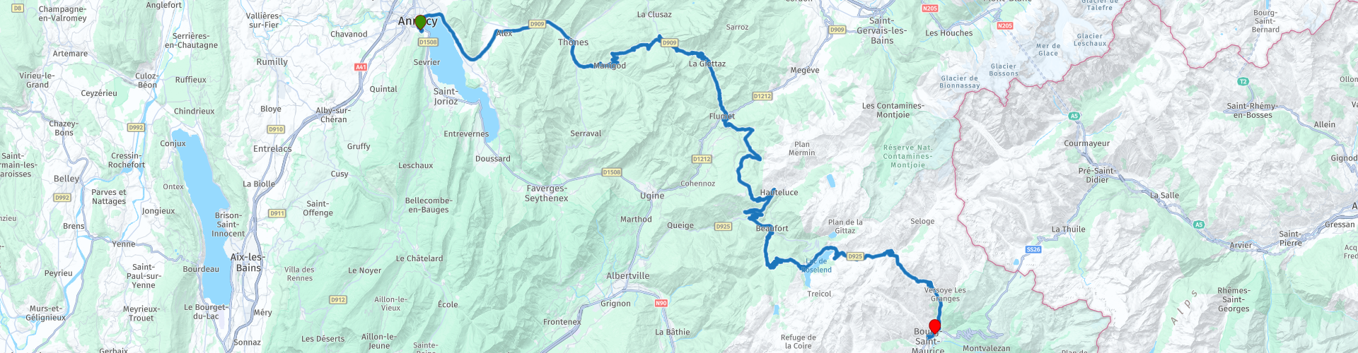
This route has many passes with beautiful curves and the necessary hairpins. We go up and down the mountain, so we have wonderful steering, with beautiful panoramas along the way. This route is in line with the previous route so we leave from Camping Municipal du Belvédère in Annecy.
On the previous route, we bowed down the 909a in Veyrier. We will stay here on the D909 where you will already have your first climb after more than two kilometers. This one lives up to its name the "Col de Bluffy" (RP2), because it is only 631 meters high.
We continue to Thônes (RP3), where the most famous alpine flower still seems to bloom in the valleys in the area: the Edelweiss. The town is also known as the production center of the famous Reblochon cheese.
We drive through Thônes and a little later on to the left into the D16, which brings you with many more (hairpin) bends and spectacle via Manigod and the Col de la Croix-Fry (RP5) back on the D909 towards Col des Aravis (RP6), just below Ia Clusaz. These cols are already starting to look like something because they are both at 1500 meters. The Alps consist of many mountain ranges or massifs and the area that you now cross is called "Les Aravis".
After these cols you go down through the "Gorges de I'Arondine", to Flumet, this town lies at the intersection of many roads and can be quite busy in the summer. We take the D218b towards Les Saisies, one of the most famous places for cross-country skiers, close to the col.
Please note: At RP8, Tom Tom and Here disagree, drive straight on at the roundabout (Here route). Tom Tom tries to get you through a loop.
A wonderfully winding road with many hairpins takes you to the D925 and the "Le Beaufortin" area, with fairly soft-formed peaks of less than 3000 meters, lots of forest and alpine meadows. In Beaufort we take the exit to Boudin. We drive via a very winding road to this still characteristic Alpine village.
AI meandering, you then take Col du Pré (RP13) at an altitude of 1703 meters and you drive along the reservoir "Roselend" (RP14), definitely stop at the end of the dam to take a photo.
At RP16 we turn the D925 back on and immediately take the Col du Méraillet. At the end this is a beautiful col with a solid descent at the end with many hairpin bends to the end point in Bourg-St-Maurice, a pleasant town.
This is a beautiful 5 ***** Star route with beautiful roads, beautiful nature and beautiful panoramas. Along the way you will pass through a number of beautiful towns or villages where you can stop for a drink and food.
Another summary of the Cols we drove;
RP2 De Col de Bluffy is located in Rhone-Alpes. This climb is part of the Alps. Starting from D 909, the Col de Bluffy ascent is 4.4 km long and is situated at 631m altitude. Over this distance you bridge 77 height meters. The average ascent percentage of the climb is therefore 1.8%.
RP5 The Col de la Croix Fry is a mountain pass in the French Alps. The pass is located on the D16 between the villages of Manigod and La Clusaz in the Haute-Savoie department. The mountain pass is best known for cycling stages in the Tour de France where it is classified as a first category pass. Height 1467m
RP 6 The Col des Aravis is a mountain pass in the French Alps, located on the border of the departments of Haute-Savoie and Savoie. It is the only mountain pass that crosses the Aravis chain. The mountain pass is best known for cycling stages in, for example, the Tour de France. Height 1487m
RP9 Col des Saisies is a mountain pass in the Alps in the Savoie department in France. The pass is bordered by the peak of Bisanne in the west and by the peaks of Légette and Chard du Beurre in the east. The ski area of Les Saisies is on the pass. Height 1657m
RP13 The Col du Pré is located in Rhone-Alpes. This climb is part of the Alps. Starting from Beaufort, the Col du Pré ascent is 12.22 km long. You bridge 963 meters over this distance. The average ascent percentage of the climb is therefore 7.9%.
RP15 Col du Méraillet is a high mountain pass in the Alps in the Savoie department in France; it belongs to the municipality of Beaufort. It is crossed by the D 925 road, which also crosses the Cormet de Roselend. Height 1605m


 Links
Links  Usage
Usage Want to download this route?
You can download the route for free without MyRoute-app account. To do so, open the route and click 'save as'. Want to edit this route?
No problem, start by opening the route. Follow the tutorial and create your personal MyRoute-app account. After registration, your trial starts automatically.  Disclaimer
Use of this GPS route is at your own expense and risk. The route has been carefully composed and checked by a MyRoute-app accredited RouteXpert for use on TomTom, Garmin and MyRoute-app Navigation.
Changes may nevertheless have occurred due to changed circumstances, road diversions or seasonal closures. We therefore recommend checking each route before use.
Preferably use the route track in your navigation system. More information about the use of MyRoute-app can be found on the website under 'Community' or 'Academy'.